Sunday, August 30, 2009

Dunstaffnage - a temporary base to explore and chore

[Kyle]From our Eriska anchorage, once I'd had my coffee, we called Dunstaffnage Marina and told them we were coming. They said to call them on the radio when we arrived. When we got there, we got no answer on it or the telephone, making for a few aggravating minutes of hovering in tight quarters in the strong wind. Eventually, someone came out in a tender and directed us in. It turns out we arrived at a rare simultaneous radio/phone failure. They were embarrassed but very friendly.

We were getting a little stressed because we had booked a car for the week and the end of the day was fast approaching. We had just missed the bus so we walked the 5 miles into town as fast as we could go and arrived with 20 minutes to spare. Once we had the car, we let out big sighs and headed to the store for a big load of heavy groceries. It’s nice to have a car.

The next morning (Saturday), for the first time since the BVI, we got up and went for a run. We were both pleased to find we weren’t in as poor shape as we feared. I suppose all of the recent hiking with heavy packs had something to do with it.


Scenic (bicycle) Trails make good running trails too

After our run we set to on following up on one of John’s (CatFlap) tips and driving up to Barcaldine to see one of the marinas about winter storage. We found a place that we really liked but the guy said he’s full for the winter. Oh, well. Back to plan A.


Ben Nevis distillery

Since we were partway there already, we decided to drive up to Fort William to see the Ben Nevis distillery. It wasn’t really anything special but the drive up there was amazing. Maryanne and I spent the whole day going down Memory Lane, including a replay of the drive past Castle Stalker. This part of Scotland is just incredible. We must have pulled over 100 times to look at the view. I’d turn to get back into the car and realize that I had missed equal beauty behind me. It was painful. I didn’t know where to look. I wanted to climb every hill and taste every waterfall.

[Maryanne]Kyle and I have now been to quite a selection of whisky distilleries, and we both agree that the Ben Nevis one is the worst.. It is an ill informed tour through a dirty/decaying factory and with lackluster presentation at that! The whisky was unimpressive too; we suspect that nearly all this whisky goes to making blends. Hmmmm.. at least the tour was inexpensive.

Fort William is a backpacking/hiking capital in Scotland and there are plenty of ways to part with your money. I insisted it was time for me to purchase some decent walking shoes/boots (mine have long since disintegrated). Kyle was none to impressed once he started to notice the price tags. Most were so expensive that the £95 I eventually spent seemed cheap. I'm now the proud new owner of some fancy black gortex trainers - initially designed for hill running (I know boots are better but boots just don't work for me, although I keep trying). Several days later Kyle is still recovering from the cost (he keeps converting to US$ too, just to make it worse).

Maryanne enjoys a girly shoe purchase session.. for walking shoes

[Kyle]A little about the Ka

The car we rented in Oban for the week is a Ford Ka (which, of course is how the English say car, which makes it even more hilarious). The thing that gets me about this is that it’s made by Ford. In the U.S., Ford has been doing all of this hand wringing about potential fuel economy regulations by saying they would have to retool everything they have, etc. at huge cost.

Bollocks! I’m sure this Ka is actually put together somewhere over here in Europe, but seriously, it’s a Ford. It’s small, comfortable, safe (well, probably not against a Chevy Suburban, but that’s another rant) and it gets a posted 67 miles per gallon. {Maryanne - we are getting 55mpg easily}. They already build loads of these cars. I bet it’s cheap, too. Although, over here everything is relative.


Our wheels for the week - the Ford Ka

Friday, August 28, 2009

Loch Aline to Eriska

[Kyle]For all you Monty Python fans: Remember "our quest is at an end!"?


Yep, you’re seeing it right, that’s it!

The Castle Aaagghhh from the movie is actually the real life Castle Stalker. It lies just north of the village of Port Appin, which is just one loch north of our planed overwintering spot in Dunstaffnage. Dunstaffnage is the first place since we left Portsmouth, Virginia where we will haul out and actually leave the boat for a while, ending 18 months and 9,317 miles of continuous cruising (and still not hauled out yet). This is why the quote from the clip is so apt.


Clip from the Holy Grail, including the "our quest is at an end" scene


We’re not quite finished yet, though, so stay tuned.

Castle Stalker is special to me for another reason. When Maryanne and I first met, she was just finishing up her degree at the University of St. Andrews. Then as I do now, I would work for a few days and then fly out to Scotland to see her on my days off. Maryanne would usually plan some sort of mini tour of a different part of the country so that I could see more than just St. Andrews. On one of these trips, we drove out to Glen Coe and then to Oban. I usually did the driving (I like driving over here). On the day we went to Oban, she really, really wanted to drive, but I talked her out of it. On the road there, we came around a corner and there it was, the instantly recognizable Castle Aaahhh. Being on the right side of the car, I instinctively started yelling, “Pull over! Pull over!” She looked at me and responded, “You’re driving!” Right! Now I understand why she wanted to drive. She had planned the surprise all along.

Anyway, well before that, we left Kinlochaline. The forecast had been for 15 knot winds out of the southeast but when we left there was nuttin’. The loch was a big upside down sky ringed by upside down trees. We were just about at the narrow entrance when I noticed another Gemini. We headed over to see the name. Maryanne put a card saying hello in a baggie and prepared to leave it on deck. As we approached, an Englishman came out and introduced himself as John. He and his wife, Victoria were from Nottingham but kept their boat, Catflap, in Oban. He was very friendly and offered us lots of advice on the Oban area.

We continued on. As it was still a nice day, we decided to take the long way and sail around the south side of Kerrera, up the beautiful Sound of Kerrera and past Oban on the way to our next anchorage. What a moment that was for me. Oban is the first place we have sailed on this side of the Atlantic where I have been before, on the aforementioned trip. It is a trick of memory that it is possible to go directly back to a particular memory and skip all of the intervening moments. It was easy to remember looking at the harbor so many years ago and thinking how pretty it was. Now, here we were, coming up the channel and passing by the city in the boat we sailed here ourselves. In fact, between Footprint and our previous boat, Prydwen, we have managed to cover the entire distance between Cleveland, Ohio and Oban on the water. It was from Cleveland that I first flew to meet Maryanne. Eventually, she moved there with me to live on yet another boat. A circle had been completed.
View of Oban town with the Folly atop the hill

This seaplane flies between Oban and Glasgow over some stunning scenery - what a way to go!


I have to go to stinkin’ work soon. I actually managed to wheedle one more day out of them so we decided not to head to Dunstaffnage just yet. It was forecast to be very stormy overnight so we found a protected spot behind Eriska Island in nearby Loch Creran. Once we were up there, it was only another mile or so to Castle Stalker. Even though we will see it next year on the way to the Caledonian Canal, I couldn’t resist, particularly with ‘our quest being at an end’ and all. (I mean, of course, just this particular run of cruising. We intend to keep seeing this world in this wonderful way as long as we are able.)

Once we got to our anchorage, we found it fairly full of moorings. There was a very small patch that had the right depth and was close enough to the island to offer protection. Our first attempt was completely unsuccessful. Just the backward pressure of the building wind with the engine out of gear had us moving at a good clip. It was as if we had just thrown out the chain with no anchor on the end. Our second attempt was better. I ran the engine up to 2800rpm and we held fast. I was a little nervous about the bottom from the previous attempt so I ran it up to 3000rpm and we started skipping backwards. Damn! It started raining really awful, heavy, cold rain. We were desperately impatient to get the anchoring over with and get into the warm. The third attempt was like the second. We briefly considered picking up somebody’s mooring but I didn’t like the idea of having someone come back and shoo us off in the middle of the storm. The radio was starting to bristle with Coast Guard warnings of ‘Imminent Gale, Force 8”. Yeesh! Also, you never know what the quality of the underwater part of a mooring is or what sort of boat it is intended to hold. We made a miserable fourth try and finally held with full reverse. As the storm built through the night, I kept worrying about the holding and popping out to see that we hadn’t moved. I didn’t get much sleep.

Thursday, August 27, 2009

Loch Aline & Catching up with friends


Waterfalls on the trail from our anchored boat to the town


[Kyle]We took the lakeshore (lochshore?) path into town. Our main purpose for visiting Lochaline was to visit Maryanne’ s University and diving friends Annabel and Mark.

[Maryanne]Lochaline is a beautiful part of Scotland and I’d visited several times before as a diver; there are some fantastic dive sites whatever your tastes (Wrecks, archeology, marine life, and dinner!). If you are not a diver, it is still a very special place to visit (at least when the sun shines), and it has easy access to the Isle of Mull to boot. I had extra reason to visit now Mark and Annabel live there.

With moving to the USA (so far from my family and friends) and now cruising, I understand that we lead a very special and amazing life. One of the downsides, the sacrifices of the lifestyle, is that we don't get to visit with either family or friends nearly as much as we would otherwise have done, and certainly not as much as we would like. So I was especially excited that I'd be able to see my old University friends.

We were anchored quite far into the loch, about 1.5 miles from the town, but close to a place we could bring the dinghy ashore. Along the loch there is a trail into town; a beautiful, tree lined path, and dotted with waterfalls – not a bad way to arrive.

Since I left Scotland, Annabel and Mark have added two more girls to the family, purchased a beautiful home in the country, and are successfully managing 2 businesses. With 3 girls and all the business work to manage, the general activity was a huge shock to Kyle and I who lead a much less intense life. Amazingly Mark and Annabel found some quiet time to share a meal (just the 4 adults) and it was great to catch up. We are so grateful for their time, but we left feeling exhausted just contemplating the life of my friends. They have 3 beautiful and happy girls, so nice that Kyle (the great child avoider) even said he liked being around them. I too loved my dose of kiddy time, at least for the day we spent hanging out with the family. They older girls had us dancing around the living room with them!

Living such a nomadic life, and mostly on the anchor, it is difficult to find showers and laundry facilities in most places – Annabel offered us both (and as a mail drop for some replacement boat parts) while we visited, and these were added treats from the visit.

We neglected to take any photos of our friends, but we took plenty of the loch, so you’ll have to make do with these – beautiful eh?


Lochaline entrance and the house of the Ardtornish estate house at the head of the loch

Tuesday, August 25, 2009

Lovely Sailing

[Kyle]The weather in Cuan Sound had been far too rough to go out in the dinghy. A couple of other boats came in to hunker down for the storm. None of them left their boats either.

The morning we left, the day dawned bright and beautiful, as if the previous two days had never happened. The other boats in the anchorage, presumably going south, left with the Sun, leaving it all to Maryanne and me. We took our time getting up and ready. We left just before slack tide at 3:00 p.m. The wind was in just the right direction to allow us to sail off the anchor, which I love.

With a reef in the main, we slowly sailed through the mooring field we had dragged through the day before. The giant boat was off its mooring and it was replaced with a tender that was smaller than the ball. As we entered the narrow part of the channel, the current accelerated us out of the sound past hills, picturesque houses with fishing boats moored out front and, most impressively, the village of Easdale, tucked underneath a huge cliff face.


Easdale town and one of the many lighthouses on route

We turned North with just the remnants of a current against us. A 41 foot monohull came chugging up from behind flying full sail and a Dutch flag. I thought briefly about tripling our sail area by putting out full sail and making a proper race out of it. In those conditions, I'm sure we could have had a knot or two on him. In the end, I decided to let him have his day. It was such a rare lovely sailing day that I actually didn't care if we were going half as fast as we could have been. We had 360 degree views of the most stunning scenery. Why rush it?

A few hour later, the sky darkened, as it tends to do here. It looked like a front was moving in from the southwest and it would be raining the rest of the day afterward. Also on the far horizon was the mast of a tall ship flying sail on the bottom three of five yards. I could imagine how a few centuries ago, such a sight would cause smugglers and pirates to throw up all available sail to escape. Chases happened at such slow speed then, with the participants spending maybe half a day between sighting and capture. We managed to round the corner into the Sound of Mull before she got to us. Just before we did so, we were joined by a small pod of our old friends the dolphins.


Duart Castle and Ardtornish Castle ruins

The rain arrived. We were pleased when it only dumped for 15 minutes and then blew off, leaving us with our previous sunny day. We turned into Loch Aline to anchor. Our original plan had been to anchor across from the town. Once we got a good look at the current flowing through the narrow entrance, we knew we would never be able to row across except at slack water. instead, we anchored a mile away on the other end of the loch by the ruin of an abandoned pier. We had a little light left so we decided to row in and hike into town to see how long it took. Everything was shut by then so we just turned around and went back. It's not a bad commute. The path is dirt and runs along the edge of the loch. Every few hundred meters, there is another waterfall crashing out of the green.

When nightfall came, we were enveloped by that deep dark that comes from being out in the middle of nowhere. The lights of the town (really, about three buildings) were way off in the distance. It was very relaxing.

Sunday, August 23, 2009

The Crinan Canal

** Caution, Long Post Warning **
[Kyle]Having looked at the currents for the Sound of Jura, I determined that we wanted to be through the 9 mile long Crinan Canal by early afternoon. This meant we needed to get an early start in order to make it there right when the office opened at 8:30. The forecast was for fine weather until the evening and indeed we got it. The skies were clear and sunny. The wind was light. It was perfect for going through the canal.

When we came around the corner for the first sea lock, the lock tender was already standing on the wall waving us in. We locked up and then paid for our passage through. While locking up, the rush of all the fresh water into the sea made so much foam that by the top, Footprint was sitting in 2 feet of suds. It looked like we were in a giant washing machine waiting for the rinse & spin. A kindly old gentleman came by and asked us if we planned to go all the way through in one day. When we answered yes, he asked if we wouldn’t mind a little company. He had a catamaran just around the corner. “A catamaran,” I exclaimed, “don’t those things just flip over?” He actually got my joke and I was rewarded with hearty laughter instead of the usual blank stare. I liked him already. He was with his wife and a man named Tom, who was some sort of nephew or grand nephew – their relationship got kind of lost in all of the other things we talked about.


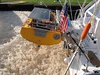
Foam in First Lock and general canal scenes

The Crinan Canal, separating the northern Clyde from the Sound of Jura, is billed as Scotland’s prettiest shortcut. I’m sure the other canals hate this and refuse to talk to the Crinan Canal at the Christmas party. Maryanne and I have seen the Caledonian Canal by road and it looked pretty nice, too. Probably, a more accurate description would be to say that it is Scotland’s most expensive shortcut, at least when the £100 fee is divided by its modest length.

After the sea lock, it was necessary to hover in the tiny basin at the top. It was maybe three times the size of a lock. The wind and the water flow kept pushing us sideways. I was turning in all kinds if circles in order to keep the engine thrust opposing them. Occasionally, it was necessary for me or Maryanne to reach out and shove off of one of the boats lining the basin. The woman on the other (two engine) catamaran looked at us like we didn’t know what we were doing. We were relieved when we were waved in by the kindly old man.

Maryanne and I have been through many locks with only the two of us as crew and we have never had a problem. Sure, it would have been nice to have somebody to handle the stern line so the helmsperson doesn’t have to get up, but with careful handling, it’s doable. So far, the locks we have been through have a long vertical rails or a series of posts embedded into the wall to which the lines are attached. Really posh locks have a floating bollard that goes up and down with the boats. Crinan’s locks have a selection of hooks and posts mounted on top of the wall. When we pulled in, since we were locking up, we couldn’t even see where to attach the lines. The only way to secure the lines would have been to throw a loop over the wall and hope to catch on something. What really would have happened is that I would have had to drop Maryanne off at the ladder just inside the lock. She would take her line up and secure it while I hovered with the engine. Then I would toss up the stern line and she would secure it. Fortunately, none of this was necessary as Tom, now Tom the Hero, was there to take our lines and secure them for us and the other boat, Snowgoose of Clyde. That’s not all. He also operated the lock.

All of Crinan’s locks except the first and the last two (out of fifteen), are manually operated. The sluice gates that let water in or out are cranked up and down by hand via worm screw. The four gates are connected to long arms at the pivot and pushed open and closed. The locks are bunched into groups of four or five. Every time, we would finish at one lock, Tom would run to the next one and ready it for our arrival, all the while being an extremely good sport about it.

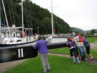
Tom and another Crew open the lock gate at lock 11

At lock five, we were told that the water levels above were too high due to the recent rains and that we would have to wait for a couple of hours as they drained it off. I kept thinking about how the tide waits for no one, but what could we do. We made the best of the delay by having nice, long, hot showers and topping up our water tanks, which had been running low since both of our manual pumps kicked the bucket on the same day, forcing us to use the more wasteful pressure system. Snowgoose picked up two more family members – the Julies, and went to lunch.


Scenes on the Canal

Bridge Opening

Once the locks were open, we were told there would be more delays as we waited for people going the other way. We passed the time by chatting to other boaters from nearby locks and the tourists who come to see boats locking through.

When it was finally our time, we entered the lock and locked up aided now by both Tom the Hero and the Julies. The turbulence within the lock at the front, where we always were, had a tendency to swing our stern toward the other side of the lock, particularly when going up. I spent most of my time in the process pulling like hell trying to shorten the line to keep us snug to the wall so we wouldn’t slam into the other side. Once we got to the top, Tom the Hero and one Julie opened one gate while the other Julie got the second. I was just making headway pulling Footprint in towards the wall when the woman, who was five feet or so away on the bow of her boat, looked at me sternly and said, “You go help her with that door!” I looked at the seven foot gap between me and the wall and, straining, let out a smile through gritted teeth. I thought she was kidding. She then gave me an I’m-not-kidding-around-here-Mister look and repeated, “Go..help..her..with..that..door!” With the doors most of the way open, the waters calmed. I closed the gap far enough to get off and ‘helped’. I was there for about the last 1/10th of the operation. This got me another dirty look. Uh-oh, Grumpy Granny doesn’t like me, and I had to face her for the rest of the day.

Once we started locking back down, we were able to be more helpful and earn more of our keep. The tie-down points started at ground level now. We were able to pull in, tie off and go back to take their lines. I helped Julie close one of the doors behind us while Tom and the other Julie got the opposite door. Holy Crap! Those doors are heavy! Each is maybe 10 feet by 20 feet of ½ inch steel plus support beams. The wooden push bar alone probably weighs 1000 pounds. Getting one moving feels like trying to push a van down the road. I can’t believe Tom the Hero did the first three locks all by himself.

We got along very well with everyone else, who were all as sweet as can be, but I just could not get on Grumpy Granny’s good side. Almost everything I did inadvertently made me come off badly. This made me nervous and self-conscious, which made me clumsy, which reinforced her belief that I was an Idiot. We didn’t really speak to each other or swap stories like with the others. Mostly, she just glared at me and would occasionally tell me that I was doing something wrong. Her parting shot to me was, “If you’re going through the Caledonian Canal, you’re going to need a lot longer lines than that.” I said that we did have a set of really long lines. We just weren’t using them because we weren’t in the Caledonian Canal and didn’t need them. This was met with a snort of what I’m sure was disbelief.

We thanked Tom the Hero and the Julies profusely and gave them a bag with enough wine, beer and chocolate for everybody. Tom the Hero gave Maryanne a big hug and me a hearty handshake. He gave us his contact details and said that when we went through the Caledonian Canal, to call him, he’d be glad to come up and help.

Snowgoose of Clyde decided to stay put for the night after the last manual lock. We waved goodbye and they waved back, plus a sneer. Maryanne and I wasted no time in getting to the sea locks. A bridge tender on the way told us we might as well slow down, the lock keepers would be taking their dinner break when we arrived. Just above the lock, we rafted up to some very nice gentlemen just long enough to be told that, if we wanted to, we could wait in the lock. Once in the lock, we tied up and had a stroll around the picturesque little town of Crinan. There were lots of tourists there waiting for the big moment. Several people noticed our flag and came up to talk about our travels and offer praise and congratulations. It helped make up for my day of being in perpetual trouble.
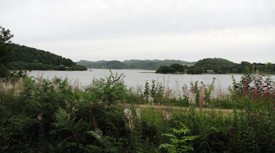
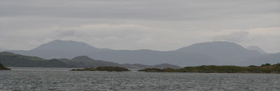
Footprint in Last Lock before sea lock

We exited the canal at Crinan and shot out into the Sound of Jura on the last of the flood that I had planned for. Man, is it pretty around here! The Clyde was beautiful, but this was something else entirely. The hills were more jagged and bigger. There were many places that had no signs of human habitation – ever. It looked (and felt, by the way) like the last ice age had just ended. A herd of mammoths grazing on a hillside would not have looked out of place at all. I could see why they filmed ‘Quest for Fire’ here. It looks like 15,000 B.C.

Exit Canal into Loch Crinan off the sound of Jura

We turned north, just ahead of the predicted storm and virtually stopped. The tide was now ebbing against us. We were barely making three knots against the turbulent, whirlpool infested seas, even with an increasing tailwind. The forecast had called for winds into the 30s with gusts into the 40s. We were trying to get to a well protected anchorage in the sound between the island of Seil, population 500, and the island of Luing, population 100, pronounced ‘Ling’. We entered the sound, Cuan Sound, as the ebb was reaching its strongest. Huge amounts of water were rushing through this whole part of Scotland, squeezing through tiny gaps to fill giant basins, turning the water almost everywhere into standing waves, whirlpools and eddies.

Cuan Sound was no exception. After we made the turn in, the current against us increased and increased. Our progress got slower and slower. Our slow speed coming out of the canal meant that it was getting dark. As we got further into the sound, we got to a point where we had to squeeze through a narrow gap between some rocks on one side and a couple of little islands on the other. We stopped. The current was going as fast as we were. Then it increased and we started going slowly backwards. Maryanne pointed at the water rushing between the islands. The water on the other side was four inches higher than the water on our side. Holy Crap! We were being swept back out into the open Sound. Wincing at having to do so, I pushed the throttle all the way to the stop, something I only ever did briefly while breaking in the engine. Our speed over the ground increased to forward at 0.3 knots. That’s 30 feet per minute, almost the length of Footprint. The engine was screaming like mad as I very gently played back and forth looking for any little lull or back eddy that I could find to get us through while avoiding the rocks on each side. In the middle, we could see the fast current streaming down one side of the little islands, curve around the bottom and then break off. This made it easier to see the slow spots and we were finally able to make it through. That seemed like a long time to spend with our hearts in our throats.

It started raining as we wound our way through a myriad of little islands to the protected part of the anchorage. It was getting pretty dark by then. There were almost no lights on shore and no stars above. I was relying pretty heavily on the radar to find anything I couldn’t see in the dim light. I remembered the very first time we ever anchored Footprint. On the way home from the factory, in Chesapeake Bay, we anchored in a pitch black anchorage by weaving our way through the boats and finding our spot, all under sail. That was a nail biter. I figured if we could do that, we could do this. The difference was that we knew the Chesapeake Bay anchorage really well. This one, we didn’t, but we were under power, so our maneuverability was better.

We found a spot in water that was a little too deep for our liking. This meant we had to put out a lot of anchor chain and rode to compensate, then we put out some more, just in case. Knowing we had a big storm coming and being afraid of dragging into those huge currents, I made sure the anchor was well set. I figured I had already used full power once today, might as well do it again. We pulled as hard as we could with the boat and the wind pulling like crazy in the same direction. The rode became bar tight. We checked for movement against several nearby objects. We didn’t budge an inch. I knew we were probably overdoing it but, hey, better safe than sorry. We’ll deal with having to get the thing unstuck when we leave. The only thing that bothered me was that we had put out so much scope that we were riding only about two or three boat lengths ahead of a giant steel fishing boat on the largest mooring ball I have ever seen. The boat was big enough and we were close enough that it kind of loomed over us. It was all you could see looking out the back. I reassured myself that if the wind shifted and we both swung, the fishing boat would swing on the mooring and essentially stay put, while we would swing on our anchor and all that rode and end up 1/8th of a mile away. Satisfied, we secured the boat, dove inside out of the rain and went to bed.


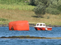
The biggest mooring ball EVER! - with the main boat, and later with the tender

I got up the next morning to pee just after sunrise and was surprised to see that the fishing boat had gone. I must’ve been pretty tired for something that size to leave without waking up. All that was left was the big mooring ball. Well, come to think of it, it was not that big. That mooring ball was big, but I distinctly remembering it being the biggest mooring ball I had ever seen, like the box a Toyota Prius would come in. I suppose in the dark of the previous night, I might have mistaken something else for an outsized mooring ball. Still, it was weird. Most of the windows were covered with condensation so I went outside in the drizzle for a look around. Maybe we swung a little and the big mooring ball was off to the side. Nope. Huh?

I went back to bed but it was still bugging me. I got up and went back outside. That mooring ball looked closer. I looked around. Nothing looked like the mental picture I had formed of the area the night before. The landmarks we had used to check that we weren’t dragging were nowhere to be found. Then I saw it. The giant fishing boat was about ½ mile ahead of us. That’s a strange way to leave, I thought. Nothing that big could get out of the harbor by going that way. Then I saw the biggest mooring ball I have ever seen, right in front of the fishing boat. The mooring ball that was behind us was now passing on the port side. We were dragging. I got Maryanne up. We both put on full foul weather gear and went outside into the storm. I looked where we used to be. The wind was blowing in exactly the same direction. We must have dragged right past the big steel fishing boat. I have no idea how we didn’t hit or how our rigs didn’t tangle. We also managed to closely avoid a couple other moored boats and a handful of fishing floats along the way. We got the anchor up until it was directly below but, with all of our strength, we could not get it up. We keep a trip line on a float for the anchor. If the anchor snags something, we can grab the float, pull on the line and the anchor unhooks itself. It’s also a good way to see where the anchor is relative to the boat. I pulled as hard as I could and nuttin’. I was just starting to think we would either have to let it go or get our resident scuba diver (Maryanne) to suit up and go see what the problem is. Then it occurred to me that if we pulled on the anchor as hard as we could, the hook would be pointing up. If I let the chain out and cleated the trip line, the weight of the chain would point the hook down. It worked. Duh.

I can only come up with one possible explanation for our dragging. Since our anchor was well set and since the direction of pull remained the same, there’s no chance that it would have pulled out and failed to reset, as it could have if the pull had reversed with certain bottoms. The harbor where we were anchored had a lot of fishing boats and a lot of fishing floats. Our trip line float looks kind of like a fishing float, particularly if it’s early and your vision is not so good. I suspect that, early in the morning, some local fisherman, suspecting he’d found an unauthorized interloper, loaded up our float and its line on his pot puller, only to find our anchor. He threw it back over thinking (hoping) it would reset. It should have, but for some reason it didn’t. It could have landed upside down on a hard, slippery stone bottom.

With two more tries, we found another spot that had the side benefit of being prettier. We got the anchor to hold to both our satisfaction. Doing all that left us both soaking and tired. The boat was cold but the bed was warm so that was an easy decision. A few hours later, I woke up and was pleased to find us in the same spot. I was debating whether to get up for good or not. Maryanne asked what was wrong. I yawned and pointed at my face, indicating I was still a bit groggy. “You still tired?” she asked.

“Yeah, a little”, I yawned.

“Then why don’t you take a nap?”

Oh, you’ve just got to love Maryanne. She is the only person in western society who doesn’t know that a cup of coffee is the solution to being a little sleepy. Still, her all natural, homeopathic solution to the problem had a certain logic to it. There was no way we were going ashore today in those winds and currents and in that rain. The homeopathic solution won.

We got up for good this time at 2:30 p.m. Actually, Maryanne stalled until 3:00. We still hadn’t dragged.


Wild Scotland - Just some of the stunning scenery after exiting the Canal

[Maryanne]This last two days have left us feeling like novice sailors, and terribly embarrassed with ourselves. We arrived at the Canal totally unprepared (undermanned), and though we would have managed, we were saved by the kindness and helpfulness of Tom. Next time we will be much better crewed for the work involved in British locks (volunteers look out). Due to delays and temporary closures in the canal we exited much later than we were led to expect, and found ourselves in adverse currents due to that delay. As we approached our anchorage the water (tide rips, and races) practically boiled in places, it was most unnerving, the confused currents buffeted the boat off course and it was quite a struggle continue to our destination. The waters of Scotland make the infamous New York’s Hell Gate look like a gentle trickle. It was such a relief to be safely anchored just before dark. Then of course we dragged anchor while asleep – our first time in 100’s of anchorings; it was quite amazing that we didn’t find ourselves bashing against the rocks nor hitting into another boat. Now we are holed up from the predicted rough winds, we find ourselves stuck aboard (the rain and conditions ensuring that we don’t want to leave our cozy cocoon). Let’s hope that our future returns us to salty sailor status.

Friday, August 21, 2009

Exploring Otter Ferry


Otter Ferry Scenes

[Kyle]First of all, I'd like to thank the Oyster Catcher Pub and Restaurant for providing free moorings and especially their free wifi out to the moorings; a much welcome gift.

The main reason we stopped at Otter Ferry was due to it's proximity to the Crinan Canal (just 4 miles down the loch), the mooring and wifi were huge additional pluses. There is nothing touristy to do around here per-se, but being Scotland, and on the shore of Loch Fyne, it is still beautiful.

We decided to just head out walking and see what we would find. We started off heading North along the shore road, heading towards a cluster of moorings thinking some settlement might be there. The walk was pretty, lined with stone walls and many times tunneled through trees. It turned out the moorings were clustered around a holiday chalet village. Here we went into the office to ask about touristy stuff, but they seemed disappointed that we were not there to enquire about a cottage, but they did tell us the best view could be seen by returning the way we'd come and heading inland instead of North... So we turned around and tried again.

This time heading inland we apparently missed our turn to the great scenic spot. We did find some nice views over rolling heather covered hills, but it was nice to be out for a walk in the flower and peat scented air. The forecast had been for rain showers in the morning, and heavier showers in the afternoon. By mid-afternoon we were still experiencing unexpected blue skies. We walked until we were pretty sure nothing spectacular would be missed by going further and were satisfied that we'd had a respectable amount of exercise, and returned to Otter Ferry.

We had then intended to go into the pub by the dock for an appetizer and a drink, before dinner on the boat, but changed our mind and decided to have a walk along the beach (this time heading South) first. Once we'd made it to the far end of the beach, and we were able to see beyond we discovered a private estate road running along the shore line - we followed that to the next bend, and then another bend, and then another.... walking for at least an hour in that direction. We finally gave up as the trail petered out at the ruins of an old boat house from which we could see all the way down to the entrance of Loch Fyne (Scotland's longest sea loch). There was lots of green and rocks and surf, and wading birds to see along the way. One surprising moment for me was when we walked into a clearing and up the hill saw an enormous mansion (stately home) - the main house of the Ballimore Estate.


Ballimore Estate - Main House

We arrived back at the pub a bit later but feeling like we earned our crisps and beer. Our time in the pub allowed us to dodge a minor shower before rowing back to Footprint for the night.

Thursday, August 20, 2009

Otter Ferry

[Kyle]If it is even possible, our next morning in Kames was even wetter than the last. In spite of this, we sailed the next leg of our journey to Otter Ferry. We know people ask us why we don’t just wait. Here’s why; in Scotland, if we waited for a nice day, not only would we lose out on all of our ‘extra’ exploring days along the way, we’d have to really pile on the miles each time we did go in order to get anywhere. Besides, we’re blue water sailors, after all, and rain is supposed to be almost entirely water. Other people in Scotland do it.

So off we went. We hoisted the sails and cast off the mooring under the watchful eye of a guy on a nearby boat who looked nervous about us making the turn away from his boat in time. A few moments later, he disappeared in the rain behind us. At least the wind was a reasonable strength. We were able to fly (and thoroughly rinse) full sail. Further down West Kyle, the rain stopped and I swear I saw a teeny tiny patch of blue sky. Great, I thought. Storm over. Uh, not so much. The Kintyre peninsula to our west disappeared behind a wall of rain. Then it was upon us. Water ran off the bottom of the genoa in sheets and poured onto the deck before running overboard. Everything went from dripping to steady streams of water. It was freezing. Man, am I getting tired of it being freezing in August.

The rain came and went in this way for most of the morning. At least the direction and strength of the wind were good. We sailed south out into the Clyde and then made the turn north into Loch Fyne, only having to make a handful of tacks to get through the wind. About three miles before we reached Otter Ferry, it cleared up - really cleared up. The sun came out and it warmed things up and made real shadows. Finally!

I studied our anchorage through the binoculars and decided we would pick up a mooring under sail. It went the same as the time before, with Footprint coming to a stop and pausing just inches from the ball. I was hoping to do that. People were watching from the shore. Maryanne grabbed the pendant with the hook and pulled but was barely able to get it to the deck. Uh-oh, I picked the one mooring ball whose pendant was wrapped around the chain underneath like somebody had played tetherball (swingball to the Brits) with it. Actually, it wasn’t just wrapped but tangled. How does that happen? It was like somebody tied a knot in it. This must be what Scottish teenagers do since they don’t have too many cows around here to tip. We alternated hanging on while the other had a go at the tangle with the boat hook. Eventually the line came free so we could get a bridle tied to it. I’m sure, from afar, it looked a little less smooth than our approach, but at least we managed to keep hold of the mooring through the whole exercise.

Then it rained.

Wednesday, August 19, 2009

More Kyles


Scenes from a soggy hike

[Kyle]It poured all night, topping us up with much needed water but also completely dampening our enthusiasm to go out. Footprint was pounding through 2 foot chop on her mooring and the wind was moaning through the rigging. Rain pelted the cabin top in waves. I got up and found little puddles all over the floor from condensation that ran down the walls at night. The windows were opaque with little droplets even though we had left the cockpit door wide open all night and slept under two blankets in order to encourage a little airflow. There was just nowhere in the air for the moisture to go as it was already saturated. Making coffee and firing up the Espar heater had it dry and comfortable in no time but anything outside had little appeal.

We made plans to just stay on the boat all day reading and doing little repairs. A couple of hours into that, however, the rain tapered off to a drizzle and then a light mist. The clouds lifted somewhat so that it was possible to see the tops of the hills. We decided to take advantage of the reprieve and row ashore for some groceries and a little walk. We also really needed a load of laundry done. The hotel had said the night before that they would do it for us for £5, so we took that, too.

We dropped of the laundry at the hotel and headed along the shore road towards Tignhabruiach {Maryanne - pronounced Tigh-na-bru-ach}. On the other side of the village, the main road split off and the shore road became a single lane dirt track. The dirt track eventually became little more than a footpath as we got further up the kyle, past the islands and into Lock Riddon. Every time we came around a bend in the path or a break in the trees, we had one breathtaking view after another. We held hands and talked about how neither of us can still believe that we get to do stuff like this all the time now. Everywhere we go seems even more painfully pretty than the last.

We walked for about three hours. Since we wanted to get back to the grocery before they closed, we decided to take a look around just one more bend and then head back. We decided to make a loop of it and use a different trail for the return. Our next trail took us steeply up into the forest through the moss and fern undergrowth along a brook babbling with peaty, tea colored water. We came to a junction and transitioned from a climb to a traverse of the slope about halfway up to the ridgeline. It started to rain lightly, which I think enhances a green place like this. The sounds of the droplets dripping from leaf to leaf and then running downhill in little streams makes the place sound as lush as it is. As we walked, the wet ground kissed the soles of our shoes with big, wet, smack, smack, smack noises. We came to another junction and resumed our steep uphill climb, this time along a fast moving river that was really just one torrent of a waterfall after another. Further up the trail, we ascended into the base of the cloud and everything became close and misty. We arrived at the top of the trail and joined the paved road that runs along the ridgeline for a while before descending back into Tignhabruaich. The rain increased from a tolerable dribble into a real rain with drops so big that when they hit the pavement, they splatter back up and add to the soaking from below. There were supposed to be good views of the kyles from up here, but with the rain and all, we couldn’t see anything. We found the next trailhead toward the shore and joined it. It only took us a few dozen steps to realize this trail was a bad idea. The rain had turned half the trail into a little river. The rest was all wet grass and mud and it was steep. I could picture one or both of us careening down the hill on our back like some kind of mad water park ride, unable to slow down or stop. We retreated back to the road. The walk back into town was really more of a march. We were both completely soaked through, our clothes sticking to as we squish, squish, squished our way back feeling cold and achy.

We got to the store just before they closed. By the time we were finished, we had each dripped a couple of gallons onto their floor. We stuffed the pack full (I carried it. I’m not a monster) and headed back to the pub for a hot appetizer and our nice warm laundry. Ooh, couldn’t wait to get into that warm laundry.

[Maryanne]We regularly discover new followers of our blog, often people we have no (or a very tenuous) connection with... For new followers, Russ and Joanie, welcome to the world of Footprint and we especially wish you a speedy recovery.

Tuesday, August 18, 2009

The Kyles


Kyles of Bute

[Maryanne]All of a sudden there is more than one Kyle in my life, we have finally reached the Scottish Kyles. In the Scottish language Kyle means a narrow channel of water between two islands or between an island and the mainland; a strait or sound, and we are sailing around in several "Kyles" now

[Kyle]Our forecast for the sail out of Kilchattan was not the best. Rain was forecast during midday, with occasional breaks at other times. For the tides, it was necessary to get underway at 7:00. When we got up, the bay was as flat as a millpond under gray skies but it hadn’t started raining yet. For the first ½ hour or so, there wasn’t enough wind to bother with putting up the sails so we motored along in the still dewy air with the Clyde all to ourselves. After a while, the wind started filling in and we unfurled the sails, shut off the racket of the engine and had a nice quiet, peaceful sail up the Clyde at between 2 and 4 knots. We hugged the east coast of Bute, splitting off from the Clyde and joining East Kyle. The hills got closer and steeper and more rugged on each side. It started to rain lightly. Traffic increased as the Cal-Mac (Caledonian MacBbrayne) Ferries started their first runs out of Rothsay, Bute’s capital.

The rain increased, but the hills steered the wind so it was directly aft. It still made for nice, placid sailing, although a little wet. We saw a few sailboats heading the other way fighting both wind and tide. I couldn’t help but wonder what kind of nut-jobs would go out sailing in this, the day was only supposed to get worse. Then I remembered what I was doing and stopped thinking about it.

At the north end of Bute, the waterway splits three ways. From the East Kyle, where we were, Loch Riddon lies to the right and West Kyle is to the left. At the meeting point, there were about a half dozen pretty little islands of tree and heather topped granite. (Bute is divided geologically, with the southern half being sandstone and limestone lowlands and the northern half being granite highlands) The winds converged at the northern tip of the island and the nice tailwind we had been enjoying turned into a direct headwind. We dashed out into the rain to furl the sails and then motored past the pretty little village of Tignhabruaich, to the village of Kames and picked up a complimentary mooring in front of the Kames hotel. Kames is exposed to the southeast, the direction of the wind and the anchorage was pretty choppy. We hunkered down inside for the next few hours as the wind, seas and rain increased. Yuck!

By late afternoon, the rain had tapered to a drizzle and the wind abated somewhat. We headed ashore and landed the dinghy in the surf on the steep, gravel beach and then heaved it up to the high tide line. We had a little walk around town to orient ourselves (mostly for the next day), and then headed to the hotel pub for a nice meal and a dram, conveniently escaping the next rain shower, before launching back through the surf to get home.

[Maryanne]As you pass by the Northern end of Bute and look upon the hill side, there are many scattered boulders. One boat skipper in the early 20th century noted that two particular rocks looked like two old women, but he could never persuade his passengers of the likeness; frustrated he sent a deck hand ashore with paint to give them clothes and faces, somehow the paint job has been maintained for over 90 years and it is (supposedly) a mystery who does it! We still think they are stretching the point though - you can decide for yourselves.


Maids of Bute


We've had a LOT of rain lately, and the only good news about that is we are keeping our water tanks topped up with fresh rainwater. With the cooler temperatures (despite it being technically summer) we are also getting lots of condensation on the boat so we are having to sleep with hatches open and doubling up on our quilt/comforters to keep warm. Despite the great scenery and whisky, we do find ourselves occasionally pining for the tropics at each downpour.

Monday, August 17, 2009

Exploring Southern Bute

[Maryanne]CONGRATULATIONS! This is our post #300 and you are still here - amazing!

[Kyle]As it was a Monday, we decided we’d only do one thing today. The night before the barman at St. Blane’s hotel loaned us a trail map of Bute. We decided we would walk the southern 4 ½ mile loop of the West Island Way, which is a trail that starts in Kilchattan and eventually runs the full length of the island.


Maryanne waiting at the Kissing gate for the toll & Kyle battling through the ferns

Ruins of St Blane's Chapel & Footprint sitting in Kilchattan Bay

The weather was gorgeous and summery for our walk. By about ten minutes after landing the dinghy and starting off, I had reduced my outfit to a t-shirt and running shorts, stuffing the rest of it into our pack. The trail started as a continuation of the road just south of the town and followed the coast around to the Ruannan-eun point lighthouse and the adjacent Glencallum Bay that we’d sailed passed on the way in the day before. (We found out Ruannan-eun is Gaelic for place of the birds or some such thing.) The trail then began climbing up the cliffs, giving us ever expanding views of the Clyde and the jagged peaks of Arran in the background. Once we were high enough, we went through a pass and were rewarded with views of a huge glen surrounding Loch na Lieghe far below. The trail descended into the glen on the other side of a small ridge from the loch. I wanted to get a photo of the loch so, against Maryanne’s feeble advice (she knew I wouldn’t listen), I fought my way up the ridge through chest-high ferns and gorse (Gorse is a horrible prickly bush) to get one. In the end, there turned out to be a better view just a little further on that didn’t require any bushwhacking. Yeah, it was easier, but where was the adventure?

On the other side of the glen, the trail passed by the ruins of the 14th century St. Blane’s chapel, with its lawns manicured by goats and its pretty views of the Firth of Clyde. From there, the trail crosses sheep fields and eventually makes its way nearly to the top of Suide Hill, the highest point on the southern side of the island. Nearly to the top? I don’t think so. Maryanne found a nice place to rest while I climbed the rest of the way to the survey marker at the top. Wow! From up there, I had a great clear view of Bute, Arran, Kilchattan Bay, the Firth of Clyde, the whole shebang. I even got a 360 degree picture of it all, too. Very cool.

The trail then made a pretty steep plunge down a long muddy slope right into the back of the town, which made us really glad we didn’t do the loop the other way. We got within a few hundred yards of being spit back out on the street when the trail turned into nothing but nettles, those horrible plants covered with thousands of irritant tipped needles. I had made it all this way in shorts with nothing more than a few minor scratches and now my legs felt like somebody was running a blowtorch over them. Damn! Maryanne thought it was hilarious, me wincing in pain as I tried to keep up with her, all smug in her jeans. Fortunately, the major pain dies off in a few minutes. A wee dram of Scottish pain killer from St. Blane’s helps, too. Even now, though, several hours later, I still feel like I spilled a hot kettle on myself. I’m sure I’ll be fine by the time Maryanne stops giggling.


Bute's Kilchattan Harbour

Glencallum Bay

Entering the Valley Pass - between Tòrr Mòr to the right and St Blane's Hill to the left

Great Scenery - Looking South in southern Bute with Lough na Leighe off to the left

Loch Ranza to Kilchattan, Isle of Bute


Runna-eun Point lighthouse at the SE corner of Bute
with the mountains of Arran in the background

[Kyle]Our forecast for the next short leg had been saying nice light winds for nearly a week. I had been looking forward to airing out the screacher and having a nice leisurely sail. When we got up, however, it was still howling and raining hard with winds in the upper 20s. The worst thing was that a swell of just the right size was wrapping itself around the corner and arriving 90 degrees to the wind, into which we were pointing. This meant that one hull was in the trough and the other was on the crest, rolling us back and forth, back and forth just enough to have us reaching for our coffee cups at the worst point to keep them from sliding off the table. This is annoying as it is, but early in the morning before all of the coffee has been consumed, it can quickly frustrate right up to the brink of insanity. We had to wait a few hours for the favorable tide. I checked the latest forecast. It now said to expect high winds all day. I tried to occupy myself with preparations in the mean time but by the end, I was wild-eyed and ranting about the bloody weather and how all I wanted was one nice day, etc.

At leaving time, the weather had actually cleared up slightly and the wind had died down a little. I was just starting to act and feel human again. We put up the mainsail with one reef in, just in case. Maryanne cast off the mooring lines, we unrolled about half the jib, and we accelerated out of the loch with the satisfying sound of a nice, fast wake hissing astern. We made a slight turn downwind which blanketed the jib behind the mainsail, making it fill and collapse erratically. I rolled it up. We were still doing a respectable 5 or 6 knots and only had 13 miles to go. As we left the loch, the wind increased slightly to the predicted 20 something and we sped up a knot or two. The Sun cracked through the clouds. I may have even allowed a slight grin to cross my face. The wind increased further into the 30s and then started nudging past 40, killing my grin and making me nervous about what little sail we had up still being too much. The wind was from almost dead astern, which was better than abeam as far as capsize risk was concerned. The bad thing was that we couldn’t reduce sail without making a dangerous turn through abeam in order to turn into it. I suspected that the wind was just being funneled at the pinch point between mountains at the north side of Arran and would die down as we got further into the Firth of Clyde, so we just rode it out, being careful to keep the wind well aft. Our speed climbed into the upper 9s and stayed there for a while. We even hit 10.2 in a 42 knot gust. I was experiencing that strange combination of emotions one gets in really bad weather. On the one hand, there was the exhilaration of being out there and still being apparently fine in conditions that are clearly ‘advanced’ or even ‘expert’. The speed was also thrilling. Our wake roared like the bottom of a waterfall. On the other hand, there was the anxiety of knowing there was little room for error. It was like the combination of thrill and fear at being on the back of a horse that’s running just a little too fast.

As we widened the distance between us and Arran, the wind did die down. I felt a combination of relief and disappointment at the ‘normal’ speeds we were now sailing. Since we didn’t have much further to go by then and since I was quickly developing a natural distrust of Scottish weather, I left the mainsail as it was. Monohulls flying full sail started to catch up to us. I started rehearsing my speech about how catamarans were intrinsically so much faster, that it wasn’t necessary to go full speed all the time like monohulls do, just in case we ran into them later. I don’t think I was buying it myself.

We rounded the southern tip of the Isle of Bute and passed into the protection of its lee. Some guy in a monohull passed us in the light winds. That was it! We unrolled the genoa but he was still making ground in us. How could that be? Oh, the shame! He didn’t even have that much sail up. Then Maryanne pointed out that cooling water was coming out of his exhaust. He was motoring, the dirty cheater.

The hills of the island were making the wind go all over the place in both speed and direction. We kept having to retrim and make big course changes to follow it and keep the sails from backwinding. It was like sailing a dinghy except with a big, heavy, less maneuverable boat. We tacked up to the head of the bay at Kilchattan and then made a quick downwind pass through the anchorage to see what’s what. We’d read that the St. Blane’s hotel had moorings for patrons and wifi. We figured we could use a meal out in their restaurant so we were looking to see if their moorings had the hotel’s name written on and to plan our approach for later. We found one we liked that was closest to the dinghy landing and then tacked back up the bay.

Then came the hard part; my plan was to pick up the mooring under sail. This is even harder than anchoring under sail because, when anchoring, anywhere where the depth is right and there’s enough swinging room will do. Usually, we’ll pick our spot and then round up to it. Where the boat stops is where the anchor goes down. It usually doesn’t matter if we’re 50 feet off or so. A mooring, on the other hand, is an exact spot. It is necessary to stop the boat within arm’s length of the mooring pendant before the wind starts pushing us back. We turned downwind and I rolled up the genoa to get it out of Maryanne’s way. As we approached the mooring, I had to leave the helm to let the mainsheet fly and then judge our inertia and the wind just right so that when we made the turn into the wind toward the mooring, Footprint would pass close enough and slowly enough by that Maryanne could get the pendant aboard and have time to get it cleated in a mad rush before we drifted too far away. As it turned out, it wasn’t necessary. The boat rounded up and stopped, lightly touching the mooring for about five seconds before starting to drift back. By then, Maryanne had just reached down with the boat hook and very leisurely picked up the pendant and cleated it, like we did this every day. It was great! I went up and dropped the mainsail. By the time I was done, Maryanne had already run a tangle of lines all over the bow. She told me to throw off the pendant and, presto, the tangle turned into a perfect bridle. We shared a high-five over our accomplishment of a no engine day.

We got everything sorted out and then rowed ashore for a walk along the ¼ mile town and then we went to Blane’s for a nice meal. Through the main bar window we could see Footprint perfectly framed, and glowing in the light of the sunset. We met the couple who had motorsailed past us earlier. They turned out to be very interesting. They divided their time between sailing all over Scotland in their boat in the summer and sailing the Caribbean in a catamaran they own a share of in the winter. They had been to all of the places we had in the Caribbean and many more. Between that and Scotland, we had a lot to talk about.


St Blanes Hotel, kind patrons of free moorings and WiFi

Saturday, August 15, 2009

Lochranza - Arran - Scotland - etc....


Scenes around Loch Ranza

[Kyle]First, let’s define some terms. Loch Ranza is the loch called Ranza, Lochranza is the little village next to Loch Ranza. The Scots do this a lot with place names so expect more. Apparently Ranza means ‘red’ in the Viking language and referred not to the loch but the colour of the pretty little rowan trees with bunches of red berries that populate the area. Loch Ranza is also the place where Queen Elizabeth II spent the first night of her honeymoon aboard the Royal Yacht Brittania.

By late morning the day after we arrived in Loch Ranza in the much less posh Footprint, the weather had cleared and the Day Star was out and shining. Maryanne and I rowed ashore to have a look around. During our walk, we found a sign that read Distillery: 1 and a 1/4 miles. Off we went.

The Arran Distillery is not old or historic in any way. Even though the island has a long history of (mostly illegal) whisky making, the Arran distillery has only been around since 1994. I have t-shirts older than that. Nevertheless, the distillery was very nice and the tour was well done and informative. The whisky was gorgeous. Maryanne and I had been worried that it would resemble the Islay variety we had on Sanda since it is from the same general region but Arran did a much better job, I think. Whisky over here is very expensive as it is mostly (nearly 80%) tax. We bought a sampler mini pack of our favorites and a bottle of their really nice cream liqueur. Perhaps if we find ourselves in a French supermarché someday (reputedly the cheapest place to buy whisky), we can load up on proper amounts.

[Maryanne]Notably, the Arran distillery does not dry the malted barley over peat smoked fires, nor does it add any peat aromas during its processing - this means that Arran whisky does not have the distinctive peaty taste typical of the Islands. Their explanation? Arran is Scotland in miniature and it can pick the taste of the region it's master distillers like best. It was good.

[Kyle]After the distillery, we headed up into the mountains on the three mile trail up Gleann Easan Biorach (pronounced: Thpthpthchackackack) toward Loch na Davie and were rewarded with stunning views of the glen. As we went further and further up the glen, the path became noticeably mushier. All the recent rain had turned much of the path into a little brook. Maryanne had on her distillery tour wellies (see Whiskey and Wildlife, July 2009). I was wearing sandals. Once we both realized that trying to keep our feet dry was pointless, we had a nice time splashing our way up the path. A couple of times, each of us mis-stepped and, squelch!, one or both feet would sink to the knee in sticky mud. With the one of us (Maryanne) pulling it usually took all of our strength to pull the other one (me) out without losing the shoe. Maryanne had one particularly upsetting moment when she sunk deep enough for the goo to flow over the top and into her boot. Eeew! Still, the scenery was very Scottish and breathtaking. That walk really made me feel like we’re in Scotland.


The trails for this hike seem to be wet, soggy streams; thank goodness it was not raining!

On the way back, we bought a few provisions and had a look at the ruin of Lochranza Castle, which has a commanding view of the Loch. On the way out of there, Maryanne spotted the most adorable little baby seal. He was only about two feet long and kept making cute little sleepy faces. Aawww!


This seal just can't stay awake

Moving On to Arran

[Kyle]The night after the loafing in Sanda was great. The water was flat calm and the boats just floated over their anchors without pulling. I woke up in the middle of the night to see the moon streaming through the window surrounded by a halo of thin cirrus – the weather was on its way. By the morning, the clouds had thickened into a solid gray mass. Occasional gusts would whip around the island and send us skittering to the end of our rode, where we stopped with a lurch as the line stretched. The gust would leave and the water would flatten and we would float around aimlessly for a while before the next one. By the time it was time for us to leave, the wind was howling constantly and it was raining hard. One by one, we watched one wet, miserable crew after another pull up anchor, and then it was our turn.

While we were still in the lee of Sanda, we put up only the mainsail with two reefs in and then turned north. Once out of the lee of the island, even with practically no sail up, we flew North up Kilbrannan Sound. The wind and waves increased by the minute and soon we were surfing down big waves while being pushed by winds of almost 40 knots. The pelting rain brought the visibility to near zero. The wind was from almost directly behind us, which is about the only point of sail in which we have no protection from our cockpit enclosure. We keep the back panels rolled up while sailing so that we have access to the sail control lines and the deck. It wasn’t long before I was completely soaked at the helm. The rain dripping down my neck and running up my sleeves eventually made my raingear about as effective as a pair of jeans and a sweatshirt. At least it wasn’t too cold. I kept thinking about the solo sailor who pulled his anchor right before us and disappeared into the rain. His boat gave him no protection whatsoever from the weather. He had no choice but to sit outside in the full force of the wind and rain. As it was, it didn’t take me too long to think we were all a bit crazy to be out here. The Coast Guard kept issuing gale warnings and dire forecasts. Maryanne, who I forced to stay inside as there was no point in us both being wet, reminded me that it was probably a choice between having good weather on a sailing day or a ‘shore’ day. Footprint is a wind powered boat, after all, and these conditions, while miserable, were not the worst we’ve seen.

As we approached our planned anchorage at Carradale, I could see that it was completely untenable. The winds were double what were forecast and they had also failed to swing so that we would have offshore winds and thus flat seas. The anchorage was a maelstrom of six foot whitecaps. There was no way we were anchoring there, so we just kept going. We had good enough speed at we would be able to make our next destination on the flood.

Looking up into the sound the day before from the top of Sheep Island had made me very excited about sailing between the green mountains on either side of the sound. I was so disappointed that today, the rain and fog completely obscured all of it from view. Nothing could be seen past the raindrops dripping off the brim of my hat except the boat and, beyond it, a featureless gray. Actually, come to think of it, I did see one fishing boat appear and disappear at the limit of visibility.

We sailed around to the protected northern side of Arran and the seas finally calmed. At Loch Ranza, the Lochranza and Catacol Sea Society have installed 12 free visitor moorings in deep water, saving us (Maryanne) from having to go through the kerfuffle of dealing with the whole anchor setup in the pouring rain. The moorings were lacking in pendants, though, so instead of just grabbing a line and cleating it aboard, Maryanne had to hang over the side and thread ours through the eye on top of the ball. The Gemini, like most other sailboats, has a tendency to bear off downwind when stopped. This made it very hard to maintain position at the ball, but Maryanne managed to capture it with both bow lines on the first try. It’s amazing what the motivation to not stay in the rain any longer than necessary can do.

We set up the rain catcher, peeled off our dripping clothes to dry in the cockpit and then hunkered down for the night. The good news is that between the wind and rain, we had full batteries and 30 more liters of water by morning.

No pictures for this blog - heavy rain and low cloud made it totally pointless to even pull out the camera!

Extra Day in Sanda

[Kyle]We had intended to leave Sanda the next morning but one look at the weather forecast changed my mind. Sanda was pretty well protected. Our next intended anchorage at Carradale was not and would have been completely exposed so we decided to spend another day at the anchorage at Sanda.

Maryanne had a good book she was working on. I decided to take advantage of our extra time here by exploring the minor isles of the Sanda group. I set up the dinghy for sailing and set off to the various rocks to the East. Mostly, I just wanted to see what was there since that part of the island was not visible from our hike the day before. It turned out to be a lot of birds and rock. I turned and tacked back towards the main anchorage against a slight current in the strait between Sanda and the next biggest island, uninhabited Sheep Island. Well, not exactly uninhabited. There were lots of Kittiwakes and the shore was strewn with Cormorants and seals. I had about five seals watching me from the water everywhere I went. As I got close to the Sheep Island shore, the ones on land would get all vocal and fidgety. The ones in the water would start splashing around and breaching. Time to tack. I would go until the water was too shallow on the Sanda side and tack back. The poor seals. Because of the current, I was only getting about 100 feet further along the shore with every tack. Just as they thought they were safe, I would turn and come back.

I found a seal free spot on the rocky beach and landed on the island. The island is shaped roughly like a bowler hat, with a flattened dome of a center leading down a very steep slope to a shallow beach. After a bit of scary searching, I managed to find a route up to the top. Once I got up there, I found a pretty impenetrable mass of waist-high plants. As I searched back and forth for a way in, I must have come too close to some kittiwake nests because they started dive-bombing me. A couple of passes came close enough that I could hear the buzzing of the turbulence over their feathers. I never saw a nest and, fortunately, never stepped on an egg. I finally found what looked like goat path leading to the center and followed it in. In the middle of the island was a grassy meadow that was just littered with bird feathers. I walked further North toward a little dip in the grass when I saw a couple of goat heads pop up and look at me. I took another step and they all bolted into the ferns. I couldn’t see goats at all, just fern tops thrashing wildly. I went to the edge of the island and poked my head over the edge. As soon as I did, most of the Cormorants took off toward the sea. The seals regarded me very nervously and then decided not to take chances and headed into the water en masse. I have no idea why a bunch of 300lb seals would be afraid of a human 100 feet away up on a cliff but they were. Maryanne thinks it was probably more in response to the general agitation of the birds than anything else.


Kyle takes a tour of the uninhabited Sheep Island

By the time I scrambled back to the dinghy, almost all of several dozen seals had taken to the water. Once the ungainly creatures were in the water and were fast and graceful again, their fear turned into curiosity…or something else. They were all poking their heads out of the water in what I swear looked like disapproval. I felt like a guy who rooted for the wrong team in a bar and was being surrounded. The wind was completely gone so I stowed the sailing rig and rowed back to Footprint. About five of them followed me, apparently just to make sure I left, until I was among the other boats of the anchorage. Even though it was calm and beautiful, Maryanne and I spent the rest of the day preparing for the night’s predicted blow. We also did a bit of loafing as well.

Sanda Island


Hiking around Sanda


[Kyle]When we got up in the morning, all of the other boats were in the process of pulling up anchor. By the time the coffee was ready, we were the only boat left. We decided to go ashore and properly explore the little 1 mile long island.

First, a little about the island; Sanda , just two miles off Kintyre, has been occupied by Vikings, fisherman, farmers and shepherds. Robert the Bruce used the island as a lookout post. More recently, the island was uninhabited except for a lighthouse keeper and owned by a series of people, most notably the bassist from Cream. Dennis, the current owner, bought the island in order to escape the rat race. He has since restored most of the buildings, some of which he rents out as holiday cottages. He also built an award winning pub by bringing supplies over from the mainland with over 100 trips on his own boat. He now runs the island with his daughter and one Summer employee, dividing his time between herding sheep and, as people of a certain hair color are wont to do, complaining about the government full-time. I’m not sure what the deal is with the sheep. He says the price he can get for the wool by the time he’s taken it to the mainland isn’t worth shearing them. He’s constantly trying to herd them from one area of the island to another. Perhaps it’s to keep from overgrazing certain areas. I think mostly, it gives him something to do and thus complain about.

Not being in a city mood, our first hike was over to the other side of the island to the lighthouse. We had not seen it (or anything else) from the sea so had no idea what to expect. As we came over the hill, we were stunned. It lies atop a giant rock on one side of a natural archway and comes with its own helipad for access.

Sanda Lighthouse

From there we climbed in intermittent rain showers to the island’s highest point; Trig Point. Our chart says the elevation up there is only 122 meters (403 feet). I don’t believe it! That climb was long and steep. We were rewarded with stunning views of the great glacial valley that bisects the island as well as both Kintyre and the Northern Irish coast we had become so familiar with.

Back down at the shore, we had a stroll along the beach as far as we could go. At one point, we encountered a small cave with two adorable little birdies in a nest. We also found a couple of sheep carcasses that had obviously come a little too close to the cliffs.

It was kind of cool having the whole island to ourselves. Dennis came up to us as we walked back to the dinghy muttering under his breath about his sheep. As his entire economy is based on tourism (mostly yachts, although he does have a boat he can collect people with if they book a cottage), we decided we should have dinner at the pub. We asked him when he opened. His answer was, “Whenever you get there.” Sure enough, the employee outran us and had the pub open as we got there.

We spent the afternoon in the pub doing pub stuff. We started with some nice hot tea and passed the time playing darts and dominoes while the other three people on the island read and worked on the computer. After a while, some people from a boat that had been across the dock from us on Rathlin came in and we had a nice conversation. I must admit to some prejudice here. On the boat were a middle aged couple and their grown son. I had assumed the boat was theirs but it turned out to belong to the son. He had just really liked boats so he bought one and was busy learning to sail it. He was really keen and we had a good time trading stories, some of which I didn’t get because he had a wee thick Scottish accent. Once it got late enough, we had nice veggie lasagnas and topped it off by sharing a whisky sampler.

Between lessons from Maryanne when we first met, who was in the Whiskey Society at the University of St. Andrews and all of the distillery tours, I feel like I’m pretty up on whisky, but it’s always good to get an idea of what the local whiskies are like. We had four varieties from the four key Scottish regions: Highland, Lowland, Campbeltown and Islay. The sampler confirmed what they say about whiskey; that if you don’t like it, you haven’t found the right one. The Campbeltown and Lowland whiskies were nice, but we both really liked the Highland. It was yum, yum, yummy. The Islay, on the other hand, tasted like charcoal lighter fluid that had been strained through an old sock. Had that been the first whisky I had ever tasted, I surely would have had to been held down for more. Luckily, it wasn’t. Just for good measure and to keep the economy going, we also added in a t-shirt for Maryanne. Now we’re broke and Dennis is rich, but we’d hate for this little gem to not be here.


Sanda Free Range Chickens

[Maryanne]We were advised before we arrived to make sure we picked up some Sanda eggs. Free range chickens feeding on seaweed apparently make for an especially yummy egg and we weren't going to miss a chance to check them out. Apparently we are not the only ones: Princess Anne has even stopped off for eggs while cruising the Scottish Islands.

Scottish whisky has distinct flavours that can (broadly) be divided by the region it came from, traditionally the Island (Islay) whiskeys are very peat flavoured since the malted barley is dried over peat fires and picks up the smoke aromas. I prefer a more butterscotch flavour - but each whisky is different and you just have to try them all to be sure :-).

Next Country: Scotland

[Kyle]The morning we left Rathlin Island, Northern Ireland for Scotland, the weather had turned back from warm and summery to thick, low clouds. Once we got out of the harbor, it started to drizzle and then rain. The visibility got worse and the wind died down to almost nothing. We put up the mainsail and the screacher to give them a good rinse. The current pushed us around the south side of Rathlin and then filled in from the north. As we were headed east, we turned a little to the north away from the South wind to maintain our course. As we got further into deep water, the current rose from 3 to 4, then 4.5 knots. The wind started to die off. Soon, we were headed 70 degrees to our intended course. Soon after that, we were enshrouded in rain and fog and being hopelessly swept toward Wales. The current would reverse in several hours but then we would be fighting both it and the wind to keep from being swept completely north of the Clyde. On came the engine. Oh, well. We needed the full set of electrics on for the fog anyway; radar, foghorn and lights. Fortunately, there was no traffic to worry about while crossing the shipping lanes. The radar only showed the areas of heavy rain that kept overtaking us.

When we finally arrived on the Scottish side, we could hardly see it. All that was visible through the fog and rain was mountainside with all of the contrast bled out. We found our anchorage on the north side of Sanda Island and found a spot tucked sufficiently behind the point to protect us from the next day’s forecast winds. Within ten minutes of our arrival, 3 more boats showed up out if the fog and anchored. We had all apparently planned to arrive right at high tide. Going ashore in the rain had little appeal so we took a much needed nap. (We had been up yucking it up with another boat a little late the night before). We were awakened by the sun streaming through the window. There were patches of blue sky!

We had planned to just stay in for the night and go ashore the next day but then we watched all of the other boats go ashore. Feeling conspicuous in our absence, we decided we should go as well. We went to the pub for a drink and to introduce ourselves. Having a boat flying an American flag around here is a great ice breaker. Usually, the first question we get asked is, ‘Did you actually sail that little boat here?’ When we answer ‘yes’, we suddenly become minor celebrities. We spent most of the evening chatting to three friends on another boat: two retired high-speed ferry captains and a schoolteacher from Northern Ireland. Before we knew it, it was dark and time for us to all head back to our respective boats and leave the Island to its three residents so they could get some sleep.

Sanda Island, Population 3! taken from nearby Sheep Island

Monday, August 10, 2009

Rathlin Island

[Maryanne]We've had 3 whole days at Rathlin Island, and we've spent those fully exploring - each day setting out in a different direction. Each evening our legs have been stiff so we know the exercise has been good for us; we found free wifi, the marina/dock is inexpensive and they have HOT SHOWERS; and it's only rained once we are home for the evening... Life is feeling good.


One of the many tall ships we spotted on our way to Rathlin Island, presumably part of the Tall Ships race, and Footprint again at a dock - what luxury

[Kyle]From Portballintrae, we left for Rathlin Island, just a couple of miles off the northeast corner of Northern Ireland. Not being in any particular hurry and since it was yet another nice day (finally?), we reefed each sail and headed for the island in light winds. I typically plan passages to have following current and have become spoiled at seeing 8 or 9 knots over the bottom with 3 or 4 through the water. (Typical sailing speeds are 6 or 7ish.) . We had a lovely couple of hours crossing the sound with nice views on both sides and the added bonus of seeing several Tall Ships along the way. We know the leg of the race from Halifax to Belfast was supposed to be wrapping up around then. We weren’t sure if they were coming or going or just sailing around but they certainly added charm to an already lovely day.

We got to the little anchorage in Church Bay on Rathlin and after a couple attempts at anchoring in the small stones of the anchorage, we resigned ourselves to tying up on the public float like everyone else did, which should have been our first clue about the anchorage. It turns out the dock is only £12.50 per day and comes with showers, so that’s not too bad.

As it was a Saturday, The little harbour was filled with weekenders from both Northern Ireland and Scotland who were all frolicking around in the water as if it were warm. Almost all had thick wetsuits on. We took a gorgeous hike first along a deserted road and then well marked trail to the southern tip of the island. The trail alternated between sheep pastures and stunning cliff views with Antrim in the background. We ended up at a lighthouse and a bay populated by a pretty large colony of seals, which were adorable, of course.


Adorable Gray Seals, just hanging out and relaxing


Scenes From the South arm of the Island

We got back to the boat and in the middle of dinner, I saw a Customs boat go by. Our big, red sore thumb of a courtesy flag had them hovering for a bit. Knowing what was coming, I went out and welcomed them aboard. The three of them were very nice. For the first time since arriving on this side of the Atlantic, we received a proper clearing in and inspection. They spent maybe an hour on board, actually copied information from our passports and boat papers and asked the specifics of our cruise, noting dates and ports of call. One of the guys even went around swabbing for drug and explosive residue. In spite of the depth of the examination, they were very courteous and we felt no sense of invasiveness. I think we were mostly glad to actually see Customs face to face and know that we’ve now been through the official process. The only discomfort we had was because it was smack in the middle of dinner so the galley was a huge mess and there were dirty dishes all over the table. They didn’t seem to care but we felt conspicuous in our apparent pigginess.

Western Rathlin Island

Scenes from the West End of the Island

Our next morning, we headed out to the end of the other arm of boomerang shaped Rathlin, the western end. The road passed over the high middle of the island through rolling hills covered by purple heather speckled with little yellow flowers. In the distance, Rathlin Sound and the Antrim coast were visible. At the far end of the island, about four steep up and down miles from Church Bay, is the West Light and the RSPB (Royal Society for the Protection of Birds) sanctuary.

West Light from the sea


West Light its Cliffs full of Seabirds


West Light is unusual in that it is reputed to be the only ‘upside down’ lighthouse in the world, that is, with the lens at the base of the tower. It is also supposed to be one of the very few all-red lighthouses. Supplies for the light were pulled by horse and cart up a long ramp to the top of the cliffs and then across to the lighthouse site. The concrete was mixed on site and poured and set by hand directly into the cliff face. The light was built with the lens on the bottom because low clouds (high fog) often obscured the top of the tower, which was still necessary as it housed the long pendulum mechanism that drove the light. Many lighthouses have red sectors to warn of hazard areas. Apparently, it was decided to make West Light all-red both because of the seriousness of the adjacent hazard and to distinguish it from other nearby lights.

At the lighthouse site was also the viewing point for the RSPB sanctuary, which was home to colonies of Kittiwakes, Guillemots, Fulmars and the adorable Puffins. The site was really well done. RSPB had volunteers on hand to point things out and answer questions. They also had binoculars (nice ones!) to lend and scopes set up for people to use. We did manage to see Puffins out at sea acclimatizing their young to the environment, but they were pretty far off. We could see them well through our binoculars but they were a bit too far out for the camera.

We had our picnic lunch and then walked home under a sky that seemed constantly like it was two minutes from raining, which, fortunately it didn’t do until two minutes after we got home.

Monday

Having done the two long trails on Rathlin, we decided to have an easy day and do the final ‘easy’ trail across the narrow part of the island to the east side; the elbow of the island (the harbour is tucked in the inner elbow). ‘Easy’ was a bit of a misnomer because, to get to the other side, the path goes steeply up then steeply down. Maryanne also discovered yet another trail that we just had to do as well if we wanted the whole set.

The main focus of our first particular path was the East Light, The one that lit up our cabin in Murlough Bay. It sits high atop a cliff with a sweeping view of the Mull of Kintyre in Scotland and the entire east coast of Rathlin. Also in the immediate area of the lighthouse was the cave where Robert the Bruce lived for a year while exiled from Scotland in the 14th century. I found a very steep path leading down to the beach but was unable to locate anything more than a couple of indentations in the rock, nothing that would offer enough protection to live. The area did have a nice view toward Scotland. I could imagine that looking out and seeing it every day must have helped strengthen his resolve to return. The legend has it that he watched a spider build six failed webs before succeeding on the seventh and so he decided there and then that he would be at least as determined as that spider to succeed.

I had a horrible steep climb back up to the lighthouse where Maryanne and I then had a picnic lunch. We sat on the grass and leaned against the wall and looked out at the fields full of flowers and the sea. Little Swifts darted back and forth, playing in the wind. The sun was shining. It was almost bordering on hot. We kept looking out at various places on Rathlin and Antrim where we have been and reminiscing about them.

We got done with our lunch and took the trail to the disused coast guard lookout point further up the coast. Before ship to shore radiotelephony, lookouts used to search for boats and then report the sightings to Lloyd’s of London. Guglielmo Marconi made the first wireless transmission for Lloyd’s between Rathlin island and Torr Head in Antrim. The lookout post has a commanding view of the entire waterway between Rathlin and Kintyre and the scenery is just breathtaking.

My favourite parts of the day’s walks were the vast rolling fields of bright purple heather that we crossed. Each clump had little complimentary yellow flowers amidst the purple and green. It was magnificent.


Monday, Rush hour on the trail, and general scenery

Saturday, August 08, 2009

Antrim Coastal Path

[Kyle]We finally got out and had a proper walk. The weather was beautiful and for the first time since being in Ireland, I wore shorts and a t-shirt all day!


Coastal Walk

We headed out from the boat to the top of the farthest hill that we could see. The trail took us via the Bushmill Steam Railway route for the first couple of miles to the Giant’s Causeway. From there, we joined the trail that runs along the top of the cliffs. We followed that for two or three more miles. Adding to our other visits, we have managed to see the Causeway from about every conceivable perspective. As usual, I would get to one point and then decide that I just had to continue on to the next one. Every time, we were rewarded with spectacular views of Green Arizona. In a few places, it was possible to lie down on the ground and stick our heads over the edges of the cliffs and see straight down. Wow!

We encountered one young guy who managed to be persuaded by his friend to stand on a pinnacle about two feet around that could only be reached by making a short hop from a patch of slippery grass. Maryanne tried to persuade me to stand on it for a picture but once I got a closer look at it, I thought the better of it. That hop could only be done by someone with nerves of steel on a no wind day. I hate to think of what would have happened if the guy had overshot.

Crazy location for a pose, and looking down on the Giants Causeway from waaaay up there


Friday, August 07, 2009

Portballintrae And Bushmills


PortBallintrae Village and Harbour

[Kyle]My original plan had been to stay in the Skerries a couple of days and explore the islands but they were too rocky to allow for a safe landing in the dinghy, plus the seals didn’t have wifi. We decided to move the boat over to the much better protected but not as pretty little harbour at Portballintrae. There were no other boats in the harbour (suspicious) so we anchored Footprint right in the middle. We found wifi we could pay for and then went ashore for a look around the town.

There was no town. Portballintrae does have a couple of businesses but is basically just a cluster of uncharacteristically large houses nestled up against the beach. We walked about a mile out of town one way then decided to turn back and see if ‘town’ was the other way. After two or three more miles, we had changed towns altogether and ended up in Bushmills. Well, since we were already here, we decided we just had to do the distillery tour. I think we’re getting to the point where we are not getting anything out of a tour of the mechanics of the distilling process but there is a sample included. For our sample, we chose the 12 year old single malt and the 1608 Reserve (to commemorate their 400th anniversary). Both were nice. I liked the 1608. It tasted more like a Scottish whisky, Maryanne preferred the 12 year old.


Bushmills Town and Kyle sampling at the distillery

We had a pleasant walk back through the town along the Bush River. Bushmills is definitely a Loyalist town. Northern Ireland does this Crips and Bloods thing with some of their towns. Towns are decorated in red, white and blue or green, white and orange, depending on which side they are on. I’m sure they think of it as a pride thing, but to me, it just seems to scream ‘if you’re not on our side, you’re not welcome here’. It’s a lot like the Confederate flag in the Southern U.S.

Anywho, we walked back into Portballintrae along part of the long footpath that stretches for miles along this coast. This took us along the river and through fields until it eventually wound through dunes to the beach. We managed to get back to Footprint just minutes before it started raining in earnest.

To the Skerries


More Amazing scenery on the Antrim Coast


Rope Bridge and Causeway from the sea


Sand Dunes and Dunluce Castle

[Kyle]We left our beautiful Murlough Bay anchorage for what ended up being a pretty cool day of fun sailing along the north coast of Ireland. We put a reef in the mainsail and two in the jib in order to allow for pretty heavy gusts and then stayed right up against the cliffs the whole way. We passed around Fair Head, along cliffs that look like green Arizona, by Kinbane Head with its castle ruin, around the corner to the Carrick-a-rede footbridge and the Giant’s Causeway. We then passed under Dunluce Castle, past cliffs and sand dunes until eventually anchoring in deep water with the stern insanely close to several rocky islets called the Skerries. (We used the engine to tug and tug on our rode, though, and we would be safely in no less than 6M of water.) The Islands are uninhabited by people and are home to Gulls, Guillemots, Cormorants and one adorable family of seals.


Seals and Sunset from the Skerries

Tuesday, August 04, 2009

Murlough Bay

[Kyle]The morning was rainy and foggy. We pulled up the anchor and left under sail for the trip north. The winds were light and variable until we left the protection of the bay, then it stabilized at a perfect broad reach and we just flew with the current up the coast. The rain stopped and the clouds became a lighter shade of gray as we sailed past green cliffs dotted with sheep and tiny villages clinging to the rock at the shore.

We sailed past Torr Head, where we had driven a few days earlier. I must say, I think it’s even prettier from the sea, except at sea, you can’t climb higher for a longer view.

As we rounded Torr Head, the current increased to 6 knots. Our course changed 30 degrees but we had to turn 90 degrees to compensate for it. There was somebody looking at us from the lookout and I wondered what it must have looked like to them; a boat rounds the point and then makes a suicidal turn straight at the rocks but then continues on sideways.

Once around Torr Head, which is a fairly sharp point, the fast current tore off into various eddies. There were flat spots where the boat was slewed from side to side, places where hundreds of tiny wavelets seemed to be coming from every direction and other places where the waves were organized into short, steep breakers. Footprint felt like a car that had accidentally left the road and was bouncing through the landscaping on the median. The current was all over the place and it was hard to steer a straight line.

Our anchorage was approaching fast. It appeared to be no more than a slight dent in the coast. From where we were, I could not see how we would be protected at all. It was also surrounded by rocks. I decided to scrap my original plan of sailing into the anchorage and started the motor. The combination of the slight bend in the coastline, which diffused the swell, and the rocks on one side actually made the anchorage relatively calm. All that was left was a long, slow swell that was rather pleasant. The shore was steep to, though and very small, with only enough room for one boat. We inched our way up through the rocks as close to the tiny beach as our anchor rode would allow and dropped the anchor in 3 meters of water onto hard sand and held fast. We had managed, as in Jost Van Dyke, to lay our anchor and chain right across a nice bare patch of sand. The water was so clear, we could see our chain as it stretched over the ripples in the sand and the grooves the links made as we swung back and forth. I instinctively wanted to dive in but reminded myself that the water only looks warm.


Views from the Anchorage, not bad at all

What a fantastic anchorage. Like Jost Van Dyke (Apr. 2009), we were the lone boat in an anchorage ringed by high cliffs. All we could see on one side was a wall of green. This ended to the northwest at Fair Head, a giant mesa that looks as if it were pulled right out of the Arizona desert and sprinkled with green. Beyond it lay Rathlin Island, tipped with a powerful lighthouse. To the northeast, we could see the hills of Scotland. We were anchored about a boat length from where the swell turns into surf so we also had the sound of the waves crashing ashore in the background.

The weather cleared up completely (huh?). We spent the rest of the day out in the cockpit reading to each other and taking in the magnificent views. At night, the beam of the light on Rathlin Island would flash four times every 20 seconds and leave window shaped patches of light on the walls. Yep, it’s a pretty cool anchorage.

Bangor and Moving North

[Kyle]Since our engine parts had not arrived, we ended up having to stay another day in Bangor. Wouldn’t you know it, the weather was pretty nice. We slept in and spent the day moving everything back into the guest berth. I pre-did all of the work that I could on the engine and then spent some time on route planning for Scotland. Afterwards, we had a nice long walk on Bangor's pretty coastal path.


Bangor Waterfront and Coastal Walk

When we woke up early the next morning, it was cold and pelting down rain. I knew it! I have been here long enough to mistrust even nice weather. It never lasts. Usually, August is when I finally start getting sick of summer. I am tired of it being too hot to even sleep until the wee hours. I’m tired of getting sweaty 15 minutes after a shower. I begin to long for nice cool autumn breezes. The same thing happens in February with the chill of winter. That’s even worse. This is the first August I can remember that I haven’t started to get sick of summer. Instead, I’m still waiting for it.

We did force ourselves to get everything done. The parts arrived with the marina mail on Monday, we immediately installed them and were soon heading out into weather it in which it did not seem sensible. The rain died off to a drizzle. With a near gale force wind behind us and a following current as well, we flew up the coast. Clouds came tearing off of the tops of high cliffs made of wet, gray rock where every crack was infected with something green. The rain eventually stopped altogether and the clouds lifted enough for us to see the tops of the mountains surrounding our anchorage at Red Bay, the only protected inlet on this coast. By the time we were anchored, the big waves of the Irish Sea had diffused to a light swell. We were the only ones here. Wow! This anchorage was not just ‘trees and water’ as Maryanne says, but also cliffs, valleys, waterfalls, ruins, beach and even sporadic wifi. Pretty cool!


North of Bangor - from the Sea

Saturday, August 01, 2009

Norn Irn

[Maryanne]According to Kyle, "Norn Irn" is how the locals pronounce Northern Ireland! Today was planned as a ROAD TRIP around the NE coastline


Sarah and Me, with Carrickfergus Castle - the first stop on our road trip around Northern Ireland


Early sights along the road - Garron Point and Ballygalley Head


Kinbane Head and Castle - a gem on the scenic coastal road

[Kyle]We were all up bright and early for the drive up the coastal route to the North end of the country. The weather had cleared overnight and we had the company of what Sarah calls ‘The Day Star’. Wow! We had all of this marvelous, stunning scenery to ourselves. There was too much of it to take in. We made so many stops, I was worried we wouldn’t make it back in time for Sarah’s flight. My favorite part was the Torr road, which was very narrow and hilly and windy and went through the most gorgeous landscape, mostly without another soul in sight. We could even see Scotland across the narrow strait.


Torr Head detour on beautiful Scenic Coastal Road

We rejoined the main route and went to the Carrick-a-rede footbridge, a swaying rope bridge originally put up by salmon fishermen to give access to their nets but now one of Northern Ireland’s biggest attractions. We got to the bottom of the hill at the start of the bridge and found every tourist in Northern Ireland cued at the line. Every person going across the bridge was stopping to get a picture of it and was hamming it up for their friends. This was slowing the crossing rate to about 20 per hour. A quick look at the line and I figured we had hours to wait. Suddenly, it was looking a lot less fun.


Carrick-a-Rede Rope Bridge and Sheep Island

On to the next thing; Giant’s Causeway. This is a World Heritage Site where a lava flow cooled very quickly into hexagonal columns. Very cool but also home to all of the children of Spain. We made a couple more scenic stops along the way and then headed back in the rain to Belfast to return the car and get Sarah back on her flight to London. We were all so glad we had nice weather in the morning for the coastal drive.


The amazing hexagonal geology of the Giant's Causeway

Back at the marina, we found out our engine parts had not arrived as promised, meaning we would have to stay at least another day until they arrive, which is a real bummer because the weather was supposed to be perfect for going north. Also, the stinkin’ wifi is still out. Aaarrgghhh!! It’s possible no one will see this until Scotland.