Sunday, June 02, 2013

Maine: Cross Island

[Kyle]After being hunkered down inside our heated cabin all day while the wind howled and the rain slashed at the cabin top, we awoke to our second morning of thick fog. At least it had stopped raining. The cold sea made for cold fog. The forecast for the afternoon was for it to be the warmest day so far for the year. We were really looking forward to that.

We raised the anchor at low tide in order to catch a lift on the east-going flood. The water was very thin at this point, so we had to navigate carefully out of Head Harbor while the fog kept the nearby rocks in ominous silhouette.


A sedate foggy trip with light winds from astern allow us to make use of the spinnaker

One we were in the open ocean we found a residual swell mixing with erratic currents and making a very uncomfortable, lumpy sea. The wind was reduced to around five knots from directly behind making the relative wind aboard zero. Not wanting to motor all day (do we ever?), we decided it was a perfect opportunity to kill the motor and to air out our spinnaker, aka the Sail of Death, called this by my one time sailing instructor because spinnakers have a history of causing a capsizing racing boats in strong winds - an unwelcome manoeuvre we'd certainly like to avoid. For this reason, we deliberately underutilize the spinnaker by thinking of it as a light wind sail only, when it’s much easier to manage and can’t produce capsizing forces.

We shut down the engines, let the wind catch up to us, and unfurled the spinnaker, which put us almost back to our motoring speed, except with a lot less noise and a with a pretty sail to watch. We couldn’t see anything else. Maine was still invisible to us apart from the lobster pot floats defining the slalom run of our course.

Noon came and went. It was still foggy and very cold. We had optimistically under-bundled and were slowly getting colder and colder, holding out for the promised sun that constantly seemed just about to win and burn off the fog. As we passed along our route, the fog would start to thin, only to thicken again, and we constantly had our fog horn sounding.

About halfway to our planned anchorage, we passed close enough by Stone Island to hear and just make out the sight of the waves breaking on its jagged cliffs. What would have been a cool sight on a sunny day seemed a little too close in the dense fog.

We rounded the northern tip of Cross Island just as the fog finally started to break. We anchored in 11m water in the bay between Cross Island and smaller Mink Island. On the mainland opposite, the uncharacteristic sight of the Cutler Naval Radio Station’s 26 giant radio towers filled the distance. The station’s transmitters are likely the most powerful in the world and are used by the navy to communicate with submarines worldwide, both at the surface and submerged.

By the time we secured everything and completed our post sailing check-list, glorious sunlight was booming into the anchorage. It became just a touch too warm within our cockpit enclosure. That, and the early morning start were luring Maryanne into the idea of a nice, long nap in the warmth of the sun. Although I saw her point, I also didn’t want to waste any nice weather. Before I knew it, the dinghy was somehow deployed and ready to go to the island. Without any more excuses, she was right along with me, packing a bag for the trip ashore.

I had chosen Cross Island mainly for one reason: Maryanne has been disappointed for years since missing a bear in the Great Dismal Swamp Wildlife Refuge that during a brief separation of paths, I spotted, and she missed, on one of my long runs. Cross Island is rumored to have “evidence of bears”. I thought it may be my chance to right things. {Maryanne: I was skeptical that such a small island would have a population of bears, but wary enough to keep an eye out nevertheless}.


We parked the dinghy at the old coastguard house - ready to investigate the interior of the island

My intent had been to go to the house at the old Coast Guard station, now used as a seasonal base for the Hurricane Island Outward Bound School, and have a quick orientation. I was hoping there would be a trail map posted somewhere outside. There wasn’t, and the house looked like it hadn’t been used since at least the previous year. We poked around for a bit and found a couple of different trailheads disappearing into the forest. Even though we knew we would have all day the next day, which was also supposed to have beautiful weather, we couldn’t resist taking one of the shorter-looking ones (how would we know?) for a bit, “Just to see where it goes.”

We ended up crossing the island to its south shore, where we came upon a beach of big, round cobble stones with great views of the eastern part of the island and the mainland coast all of the way to Canada.


Stunning Maine scenery - beautiful fresh, lush forest growth and wild coastlines made for great hiking


The cobbled beach, framed by the sea beyond and the rocks and fir trees ashore was beautiful, but every footfall on those cobbles brought rapid movement of a spider scurrying away into the stony layers of beach; definitely not somewhere for a relaxed picnic!

Before heading back home, we decided to at least walk the length of the beach. At the other end, Maryanne spotted another trail marker. Figuring it must go to the next headland, we decided to follow it, “Just to see where it goes.”

Half an hour of steep up and down later, we emerged from the forest atop a steep headland with dramatic views of the rocky cliffs either way. It was one of those places where everywhere you look is beautiful and the word “wow” gets way too much use every time something a new vista reveals itself.

We continued to find new trail markers pulling us further on and repeating the same theme, until we both knew we were pushing it too far. It was going to be a long hike back to Begonia if we kept going outbound.

Suspecting that our trail may actually be a loop that bisects the short part of the island back to the house, we agreed to continue a bit further in search of the shortcut back. If we didn’t find it, we would return the way we came. Shortly thereafter, we started having difficulty finding the trail at all. We would start up one lead or another only to lose it and have to backtrack to a known position. During one of these backtracks, Maryanne found an engraved wooden sign at a crossing, saying “House” and pointing in a direction clearly across the island’s narrow aspect. We had our shortcut.

The trip back was through a fairy-tale enchanted forest covered at every point with many varieties of soft, thick mosses. Most of the walk felt like it was on the world’s biggest featherbed. Maryanne was feeling especially smug because she had worn her sea boots (wellies), while I was wearing sandals, since I thought we had only originally intended to have a quick look around. Following behind her, I was able to avoid most of the wet spots by avoiding where she sunk in. I did get surprised enough, though, to have thoroughly soaked feet early on. At least they were sandals, which drained and dried fast, but every time I re-soaked a foot, she’d let out a little laugh.

At about the middle of the island, we came upon a split for a new trail that was clearly headed the wrong direction. We each shot a “Don’t even think about it!” look at each other and silently agreed that it would be the next day’s goal.

Back in the dinghy, approaching Begonia from ahead, Maryanne reported that our anchor bridle lines were vibrating. They do this when the current is particularly strong. The outgoing tide was streaming through the gap between Cross and Mink Islands, sweeping us toward the boat very quickly. Even with the warning, we got to the stern and only by mad rowing in the turbulence of one of the hulls was I able to hold position so Maryanne could grab hold of the main boat. The topsides are pretty high on Begonia, so we made a mental note to leave a low-hanging cleated line that could be grabbed from alongside for future excursions in potentially strong currents.

The following morning, with picnic packed, we timed our departure from Begonia to get just the slightest push from the very beginning of the current as we went toward the Coast Guard house to tie up. Since it was low tide, it was necessary to haul our Pudgy a long way up the rocky beach to the spot where she would be floating on our return, also planned for just after slack water the other way.


Our second day ashore, and once the dingy was hauled safely up the beach the first trail took us to the outhouse! (Not part of the scenic tour at all!)

On our way to the trail we had decided to hike for the day, we spotted yet another and a sign saying, “Shore”. It headed in the direction of the beaches within view of Begonia, so we decided to have a look. It didn’t take long before we realized the shore trail didn’t actually go to the beaches, but was a return trail to the house that ran near shore. When we got to where we could see the beaches, we left the marked trail and cut through over fallen trees. The tide was still very low, the cove was a very wide expanse of rock and mud. Three men from a fishing boat anchored nearby were squelching through the mud digging as their skiff lay high-and-dry on the beach. Not having learned my object lesson from the day before, I stood at the edge of the pebbles in my sandals and waved hi. “Uyuh” and a wave were the response.

Maryanne, wearing her sea boots again, happily squished her way through the mud to introduce herself. She thought they may have been collecting bait worms, or possibly the whelks that littered the tidal flats, but it turned out they were digging for clams to sell directly. It looked like backbreaking work, particularly in the hot sun. Each man was using a claw with a short handle like the end of a pitchfork to scoop up a big batch of mud, which was then sifted for clams. We wondered to ourselves why they didn’t use pitchforks so at least they would be able to stand upright part of the time instead of being bent over constantly. I’m sure at some point, someone considered that and there’s a good reason why they don’t.


Backbreaking work for the Clammers on the beach, while we could retreat to the shade of the forest

When one of them asked what we were doing, Maryanne answered that we were taking advantage of the nice weather to hike the trails. His response was, “There’s trails on this island?”.

“Uyuh.”. They appeared to have been visiting the island for years; it surprised us to realize that they knew little of it beyond the clam filled beach.

We rejoined the trail and then backtracked toward the center of the island. Further along, we saw another junction with a new trail marked with the same orange ribbons as the one we'd lost the day before. We figured it must be the other half of the loop and followed it, hoping to find the spectacular cliffs again from the other side.

We emerged well down the rocky coast from where we lost the trail the day before. This time, we were able to pick our way from one “wow” viewpoint to the next until we eventually joined our old trail. Maryanne protected me by finding the boggy spots. It mostly worked, but I still refreshed my sandal water often enough to keep her chuckling at my expense. At one point she sank a little too far though and cold muddy water spilled over the top into her boot. A wave of horror, disgust and discomfort caused a grimace to slowly cross her face. Ha! Justice! Once she finally extricated her foot and boot I gingerly stepped around the boot shaped hole as it slowly refilled. I had a moment of guilty joy until she pulled off her boot and emptied half a gallon of very peaty, coffee colored water onto the ground, then I just felt bad for her. In that boot, that foot was going to stay wet until we were done for the day.


Another rare, beautiful Maine day

It wasn’t too much longer. Back at the junction for the shore route back to the house, we rejoined and completed the entire loop feeling fairly certain that we had completed all of the island’s trails.

Back at the dinghy, the water still needed to come up another couple of feet before it would float – maybe twenty minutes. We killed time by going into the old coast guard house.

There was a sign at the door asking visitors to sign the guest book, make use of anything they like, and leave the place better than you found it. The guestbook and pictures left behind by earlier visitors reminded me a lot of the many camping trips we used to take at school. On the table was a trail map. We had missed one after all, but it went way over to the far side of the island through the wetland zone in the middle. We were sore and tired enough to be sure we couldn’t have made it.

Relaxing on a bench outside the house, waiting for the last of the tide, Maryanne spotted what initially looked like reflections from a plastic bag fluttering on the rocks. Closer inspection revealed it to be a very animated seal. I got out the binoculars and found it to be the most adorable little baby seal. His animation appeared to be caused by frustration at not being able to find a comfy rock. All of the big, flat rocks were too high. He would try to get up on one of them for a while, then resign himself to one of the really uncomfortable looking sets of pointy rocks within reach. That would last a few seconds, then he would let out a little cry and struggle with much difficulty over to the next comfy looking rock that turned out to also be too high. The poor thing, he was little enough that I wanted to go over, pick him up and put him on the biggest, flattest, warmest rock around. I didn’t, of course, because I knew he would either bite me or flee out of fear. I didn’t want to cause him any more trauma than he was already going through with the lumpy rocks, but it was hard to watch.

When we got into the dinghy, I tried to go past very slowly and give him a wide berth, but he spooked and headed for the apparent safety of the water. Once he was in his comfort zone, curiosity took over fear and he accompanied us for a time as we rowed home (from a safe distance).


Maryanne waits for the tide to climb, and a glimpse of the Cutler Navy Base Submarine Very Low Frequency Radio Towers at sunrise - an unexpected site in an otherwise untouched area of the world

Wednesday, May 29, 2013

Finally, a Nice Day for Messing About in the Water

[Kyle]I was so pleased when I stirred the next morning just before the 4:52 sunrise to find only a single tiny cloud far in the distance. I didn’t really need to be up for a while, but once I realized the sunrise was imminent, I just had to see it. It was cold inside the boat (about 40F, 5C), but since Maryanne was still tucked into the warm bed I decided to skip firing up the heater and wait for all of that glorious, unimpeded sunshine to warm the boat.

The warmth eventually brought Maryanne out into the salon, where I handed her a hot cup of coffee to help. We planned our day and readied Begonia for departure.

The wind forecast was for a whole morning of nuttin’. The sea was a mirror speckled with lobster pot buoys and slowly undulating with the remnants of the wakes of long-gone lobster boats.

We motored into relatively buoy-free water and optimistically set our spinnaker, hoping to catch what little there was of the wind. It turned out to be a refresher on making sure everything was rigged correctly. There wasn’t even enough wind to hold up the fabric against its own weight, much less pull a 12,000lb boat.


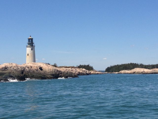
Calm morning has us motoring from start to end, passing Moose Peak Light towards the end before any hint of wind

So, we stowed the spinnaker back in its deck bag and fired up the starboard engine for the rest of our journey to Cows Yard, a tiny basin in the Wass Archipelago. Along the way, Maryanne continued with her pressure cooker experiemnts and prepared cornbread to go with the Chilli we were also preparing. It came out well – nice and moist and consistent all the way through. The only thing missing was a slightly drier crust. Cornbread is now added to our options for the meal planning aboard.

The Cows Yard is a pretty little basin between Harbor Island and Steele Harbor Island that is dotted with rocks and an assortment of pine-topped islets. It reminded me of an alpine lake. Later, as the tide receded, clusters of rock were slowly revealed all around us until we were eventually the sole boat in a small cove surrounded by trees whose tops had grown higher by 20 feet. I speculated that the name could have come from the resemblance of the brown rocks to a field of sleeping cows. Maryanne checked up on this, as she does, and learned a semi-related fact that a Cows Yard Tar is a Maine-ism for a fisherman that likes to farm or vice versa. Fine, but I like mine better.

The Cows Yard supposedly has room for several boats, but it took very careful placement of our anchor and rode to keep from fouling a lobster pot float. By the time we were secure, a breeze had started to fill the anchorage. Since we hadn’t had a chance to do any sailing that day, we lowered the Portland Pudgy and rigged its sailing kit for a tour of the anchorage. It was the perfect situation for use of the sailing kit; there was a nice breeze, there was more distance to go to see it than was reasonable by rowing, and it was just a beautiful, sunny afternoon.

Believe it or not, this was the first time we had ever sailed the Pudgy since we bought it to replace our old one. When it arrived, it was during the frenzy of the refit in Virginia. Since then, I was on a hectic delivery schedule, and then we were in New York, where I wasn’t in the mood to dodge heavy shipping with it. Anyway, fast forward a few months and we finally got a chance to break out the sailing kit. We loved spending the day pottering around the anchorages in our last Pudgy. It was nice to be cruising again and nice to be back in our little sailing dinghy.

Since our last version, the sailing kit of the Pudgy had been repowered. It now had a much bigger rig with both a telescoping mast and boom, which pulled us along nicely in the light, shifty winds. We spent a pleasant couple of hours playing the breeze as we weaved our way through the islands near the anchorage. We disturbed a couple of adorable seals sunning themselves on a rock as we approached a little too close in the strange, orange boat. Later on, we caught several curious ones watching us from the water as we passed by.


Compare the size of the boom and sail on our earlier (left) and current (right) model of Portland Pudgy sail kit

Since I knew there were rocks down there under the high tide line, I was conservatively keeping near the middle in order to avoid grounding the Pudgy’s daggerboards. Then Maryanne realized we have electronic charts on our Pudgy. Actually, we have a handheld basic GPS and spare batteries in the emergency kit we carry aboard. It gives position, speed, distance, etc., but no charts. Boy, times have changed since last time we sailed our Pudgy. This time, we had chartplotter, wind meter, camera and uh, phone, I guess, on our iPhones. I steered while Maryanne snapped photos and kept us in the deepest water. We even had a track display, so I could see how we were doing against the wind and current.


Kyle has fun, as he sails me around the island, I sit back and enjoy the views

When we got back to Begonia, I was still in the mood for more, so Maryanne started dinner while I went almost all of the way back out to the open ocean before making my way back.

Since Cows Yard has a relatively small space that’s safe for anchoring, I was eager to get a good look at the anchorage the next morning at the lowest tide of our stay, when we would only have a few inches under the keels. I came into the cabin and everything was gone! The fog was so thick, that all I could see was Begonia and about three of the local lobster pot buoys. The double tone of nearby Moose Peak Light could be heard. Maryanne joked it says, “Moose! Moose!”

The fog comprised the nice weather before the approach of a warm front that was forecast to bring wind and increasingly heavy rain as the day progressed. I used the nice window to re-stow the Pudgy and its sailing rig and prepared for another dreary indoor day. The next few days are forecast to be glorious and have us breaking out the sun cream.

Monday, May 27, 2013

Into the Wilds

[Kyle]I awoke at 3:00am completely rested and refreshed after nine glorious hours of sleep. Outside, it was dark, but I could see the moon! This meant that for the fist time in days and days, it was clear out. Finally!

Clear at night also means cold. I made coffee while Maryanne slept a little more. Begonia’s interior filled with steam from my breath and the kettle, neither of which would dissipate. The record rains of the previous week had made it really humid inside and out. I toughed out the cold as long as I could bear, then fired up the heater, lifting our indoor fog. {Maryanne: I've no idea why Kyle chooses to suffer so much, I'd have turned on the heating immediately!}

Maryanne got up and the two of us finished the last of our preparations for our early departure. Apart from having to bundle up against the freezing cold, it was a beautiful morning. The sunrise was the first non-gray one we’d had in a while. Once it cleared the hills, it burned off the dew coating the boat, and then the greenhouse effect from the enclosure warmed the cockpit.


A beautiful clear, calm morning

Once clear of the Somes Harbor mooring field we raised the sails in the light winds of the Sound. As we headed out of its protection, the winds gradually built until we were streaking along at full speed across Frenchman Bay in winds of the perfect direction and strength for fast sunny-day sailing.

With such great conditions, I was even able to sit in the sun on the forward deck and use our autopilot remote to dodge pot buoys and lobster boats.

Once across Frenchman Bay, we passed Schoodic Island. I was looking forward to this. Even though Mainers generally refer to the entire Maine coast east of Penobscot Bay as “Down East”, most of the cruising sources I have checked with seem to agree that Schoodic Island marks the limit of the Down East cruising grounds, beyond which lies a wild frontier. As you go east, we are warned, the tides get bigger, the currents stronger and more unpredictable, and marine facilities are all but non-existent, particularly for non-lobster “yachts”. It sounds to me a lot like Scotland. I’m sure Nova Scotians call it something like, “The Bunny Slope”. Since self-sufficiency and remoteness are our kind of thing, I couldn’t wait to see some of the less visited gems off of the beaten path.

We proceeded one point beyond Schoodic and rounded stark and lonely Green Island, just off of the end of the Petit Manan peninsula, before rounding up into the wind and beating towards a deserted spot on the beach along its eastern shore, where we dropped anchor for the night. Thanks to our early start and fast sailing, it was still well before noon.


Kyle steers the boat with the remote from the foredeck (dodging the minefield of lobster pot floats), and finds a patch in the sun to sit. Eventually we round at Petit Manan Island light (on green island) before anchoring in the lee of the wildlife refuge

From our anchorage, there are no signs of human habitation except for the giant lighthouse on Green Island; it’s associated buildings and the lobster boats tracing erratic paths around their traps in the distance. Our spot along the beach looks unprotected, but it’s an illusion. As the tide recedes, the slight swell turns into nearby surf, robbing the waves of their energy and flattening the water at the anchorage. Eventually, the surf itself stops, and a semicircle of rock is revealed, putting us in the middle of a horseshoe shaped bay.

Amazingly, in spite of our obvious remoteness, we have a WAY better cell-phone signal here than we did in the middle of Somes Harbor, surrounded by houses and within line-of-sight distance of the little village of Somesville. We even have 4G! How does that happen? It is a surreal experience to be able to surf the Internet where a search with our best binoculars doesn’t even turn up a lamppost. I still remember thinking a twenty-foot phone cord was a luxury.

So it looks like our blog backlog (backblog?) will get out a little sooner than we thought. {Maryanne: We spent the afternoon with the luxury of internet and great views, and watched the local bird populations swoop and squawk until finally settling for the evening}

Mt. Desert Island, part 2

[Kyle]After my next trip to work, the vicissitudes of airline scheduling meant that, in this particular instance, I could get home to Begonia a day and a half earlier if we rented a car and Maryanne made the three-hour drive to get me in Portland. We finally crawled into bed after a freezing row in sideways drizzle from shore at about 2:00am.

At 6:00, we got back up. It was my third day in a row of similar amounts of sleep, so I was really struggling with it. A rental car for us is a rare and useful treat. We only had it until noon, so we wanted to make the most of it before we had to take it back. Maryanne had it all figured out already. All I had to do was stay awake and drive.

{Maryanne: OK, right now I feel any reader may be distressed at my disregard for Kyle's health and his need for sleep. The reality is that Kyle has had little time to enjoy ANY of the places we've visited since Boston. We are supposed to be cruising, but really Kyle has just been sailing between commutes to work. We were in sight of Arcadia National Park, we were about to leave, and we had a few hours use of a car. I really didn't want Kyle (or myself) to miss out yet again. He can sleep later. As we set out it was drizzly, and with low cloud on the hill tops, but the forecast was for it to clear, at least slightly; it was all we had, and I'd make the most of it, Kyle would appreciate me after the fact!}

We headed for Acadia National Park and its 27-mile park loop road. The most efficient thing, time-wise, for us to have done, would have been to have driven the loop the night before in the rain. Then, it would have been a simple time/distance calculation. By morning, however, it had stopped raining and all of the daylight made it possible to actually see all of the trailheads and scenic overlooks. There was NO way we would be able to do all of those great 4½ mile hikes in a week, much less a few hours. It was painful to have to skip so much. It was great that we had at least some time to see it.

We made a list of must-see stops, and then and then raced from place to place in a mad dash. We’d park the car, run up the trails to the viewpoints, run back, hop in and take off. We must have looked to everybody else like we were on some sort of competitive timed treasure hunt.


Island first spring water source(now covered), and some pleasant spring hiking


Ocean Surf and Mountain Tarns


Kyle LOVES it


The surf explodes at Thunder Hole

We made it back to the rental car place right at the last minute of our rental period. They were kind enough to drive us back to the boat, saving us the 6½ mile walk. Even though we were exhausted, we decided not to waste a minute of our remaining time here, and refused to return directly to the boat (the rain had practically stopped!). There was a small museum that Maryanne had spied just five minutes from our boat and wanted us to explore. The museum was closed (too early in the season!) so we wondered about and along the way we found a trail that ran along the shores of one of the lakes. We took it. At the other end, the trail seemed to go right into somebody’s back yard and up the side steps attached to the house. Not knowing what else to do, we tiptoed past, only to find at the front of the house that it was actually the headquarters for a private conservation organization that manages the trails, among other things.


The town museum was closed, but we followed water up-stream from the mill and found fish ladders and eventually found woodland trails leading us to Somes Pond and Somes-Meynell Wildlife Sanctuary

We met a woman in the parking lot, who suggested we go in through the house to the back deck for some nice views of the lake. We initially surprised the Director inside with our intrusion, but he quickly warmed to us, and we soon found ourselves in a long conversation about the lake, the trails and the various conservation efforts underway, particularly the loons and the alewife, a herring-like fish.

We made our way back to the dinghy in meandering fashion, stopping every now and then to see something interesting. Once we were there, I just knew that if we stopped moving, we would fall asleep here we sat. Since it was close to high tide, the harbor had ten more feet of water in it than it had when we left for the drive. Many of the impassable muddy areas were now deep water. This allowed me to kidnap Maryanne for a pretty row around Sheep Island before we actually got back to Begonia for an early night.


We end the last of the daylight hours with a row around the island in the harbor

My Adorable Dynamo

[Kyle]When it came time for me to leave for work, just before three the next morning, it was foggy and had been raining between a light drizzle and a downpour all night. In order for Maryanne to get the dinghy back after my row to shore, she had to climb out of our nice warm bed and accompany me so that she could row it back home. Actually, she did me even one better and graciously bailed the previous night’s rain out of the dinghy while I dressed for work.

When we got to shore, the rain was down to a light mist, so she decided she could use some exercise and joined me for the 6½ mile walk to the airport. Our walk started on an empty road through dark forest and finished just after sunrise as we arrived with the staff opening the terminal. She waited until the other passengers and I were called through security, we said our goodbyes, and then she walked back home!

I got a text from her saying that she was back at the boat around the time my second flight landed in Newark.

I was pretty impressed. Then, about an hour later, I got another message that she had left the boat again, walked about a mile to the nearest gas station, and then filled up a six-gallon jerry can of diesel and returned home. The main road has a good paved sidewalk she could roll our cart over, but the last longish bit she would have had to pick up the can and carry it to the last ¼ mile or so to the dinghy dock. {Maryanne: Actually the cart rolled a LOT further than Kyle imagines, but I'm enjoying having Kyle think I struggle more than I do, so let's keep that quiet for now}

A while later, I got another message. She was looking for lost a stash of flour (she was going to do some baking) and wondered if I had tidied up and put it somewhere unusual. After a little back and forth, the flour wasn’t found, but in the process, Maryanne had turned the boat upside down, so she decided to just give our food and galley stores a clean and reorganization.

I was working a 10-hour day and I was feeling lazy!

[Maryanne]Once Kyle heads off to work, I try and share my days alone with both chores and fun. The forecast for the next few days was pretty miserable, and I determined it best to stay aboard. The location surprised us with having no wifi, and (more importantly) barely even a phone signal for much of the time. Occasionally I'd be able to get a text off to Kyle, but had no reliable signal, and surfing the internet was frustrating enough to be avoided completely. I was longing to explore some of what Mount Desert Island had to offer, and had hoped to spend some time in Bar Harbor itself; the weather made this totally unappealing, and I declined the opportunity, sulking somewhat!

Eventually it was time for Kyle to return. He was not able to fly back to Bar Harbor (poor timing of flights and his work schedule), so we'd organized for me to pick up a rental car and drive to Portland to meet with him there. Renting a car also means I can do more extensive grocery shopping, etc. Always a bonus. However it continued to rain, and I continued to have poor if any internet. What I determined (rightly or wrongly) was that it was too early in the season for a bus service, and I was going to have to walk to collect the car. I set out in a light drizzle and to aid the speed, took our little kick-scooter (a skateboard with handlebars) - what could go wrong?

First bail the dingy of two days of heavy rain. Load up bags for shopping, GPS for car, etc. Row ashore and secure dinghy. Hike to rental car location, making use of scooter when not too much uphill nor too steep down-hill. Tumble into a face plant only twice (being careful not to fall into oncoming traffic). Rain gets heavier, my coat is wet enough that it seems to have come right out of the washing machine. Eventually arrive (early), nobody there! Find note to call a phone number, call, and await arrival of manager. Manager arrives, and do paperwork. Here is where I discover I can't find my purse, and therefore don't have my drivers licence nor my credit card. For some reason few rental companies will loan out a car in such circumstances. I can't believe it, I've just walked for 2 hours in heavy rain, and I've got go go back to the boat and look for my purse. How COULD I have been so stupid? Maria, the manager takes pity on me, and to avoid a scene of tears and total breakdown, drives me back to the boat and watches on while I row back to Begonia. Here I tear the boat upside down and still don't find my purse. Could it have fallen out when I fell? Or maybe be in the bathroom at the airport where I changed out of my wet over-clothes? Either way I have to return to Maria so I row back, still not sure if I can even rent a car, nor how Kyle can possibly find his way back home. Luckily I do have emergency credit cards stashed on the boat, and my UK driving license, so I take these and hope they will work. On the drive back to the rental office, we keep eyes peeled on the road for a lost purse (a very small black purse, and yes, it's still raining, no luck). Maria sympathises and accepts what I can offer her, and hands me the keys for a lovely car. I load it up with my grocery bags, set-up my GPS, and as as I'm hooking up my phone to the car power discover my missing purse. Doh! it was in the bag all along, now I really feel stupid.

I make a dash for the grocery store, return to the dingy to stow our new supplies, and then return to the car for the three hour drive to collect Kyle. I take the scenic route, and stop for a lobster sandwich; I tell myself I deserve it.


I treat myself to a lobster sandwich from one of the many lobster pounds on route. Yes, they cook outside, in the rain, and isn't that lobster claw cocktail stick cute!

Mt Desert Island

[Kyle]At our unexpected overnight anchorage, the fog had lifted a few feet by the next morning to about twice the treetop height, revealing a wild rocky cove without a stick of human presence. Four big seagulls combed the gravel beach on the outgoing tide. The only other thing in the glassy cove besides Begonia was a lone lobster bot buoy some distance off. The air was cold and moist and smelled like wet earth and pine. It was very peaceful.

Our every noise was magnified as it echoed off the low hills. When we weighed anchor, the chain coming in over the roller sounded like a dump truck unloading a load of stone. Sorry birds.

With only a few more miles to go and all day to do it, we had a really nice day of sailing for the pleasure of it. The wind was still slightly unfavorable for our course, so we enjoyed making long tacks from one island to another, disappearing into the fog in between. Along the way, we called out pots to one another as we weaved through the fields.

As we sailed through the Western Way toward Southwest Harbor, the fog lifted to a higher layer of stratus drizzling ever so slightly and the wind slowed and fell astern. The tide was just beginning to flood and we soon found ourselves gliding silently up Somes Sound past beautiful, stately homes, most of which still looked closed awaiting summer.


Sailing up Somes Sound, and reaching Somes Harbor - our home for a few days

At the northern end of the sound, in Somes Harbor, we found ourselves in the company of hundreds of moorings, but so far only two other boats. We were able to find good holding for our anchor ahead of the field not too far from the public dinghy dock. Our timing was good, however, and the weather held off pouring rain again and blowing hard until we were safely at anchor and inside. Even through the next wave of miserable weather, it was hard not to feel lucky. This place is so beautiful, even in the rain, perhaps (a little) because of it. We fired up the heat, Maryanne made a big batch of potato soup, and we spent the evening sharing a bottle of wine and reading to each other.