Monday, May 31, 2010

Shetland Isles


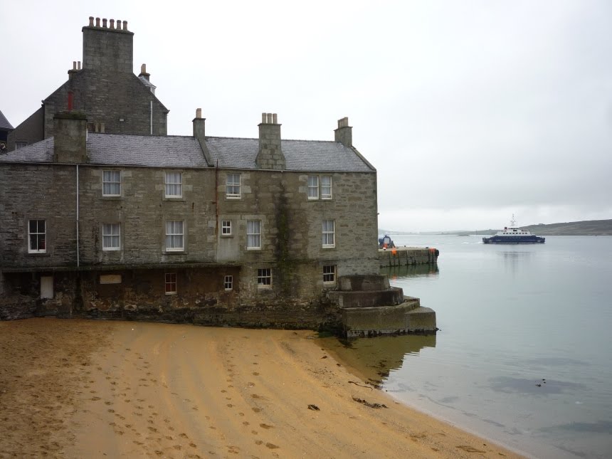
Sights of Lerwick, capital of Shetland

[Maryanne]Shetland; the most northerly islands in the UK.

Fair Isle (between Ornkey and Shetland main Island) is technically part of Shetland, and we didn’t mention on our Fair Isle blog that it is famed for its sweaters. The “traditional” Fair Isle pattern, although relatively modern, was first knitted in the islands (from local wool) and soon taken up by royalty (in the 1920’s), making it rapidly popular world wide. Although a single pattern and garment may contain many, many colours, each kitted row, generally only contains two; that’s hard to realize unless you know and inspect the knit. Pretty cool. Knitting is so part of the Shetland culture, that it is still taught in local schools to all the kids (actually those classes are big news right now as the local education department plan to save costs by stopping the knitting lessons, such politics).

Links to Norway here are strong, in fact the islands were owned by Norway until a ruling king couldn’t find the cash for his daughters dowry and gifted Norway in lieu of funds to Scotland; he thought the gift was a temporary thing (until he could get the fund together) the Scottish thought otherwise and kept it. Given this history, there are lots of Norwegian sounding place names, plenty of Norwegian in the dialect, etc. A relationship not forgotten between the two nations was proven by the amazing support Shetlanders gave German occupied Norway during WWII – just look up the fantastic stories of the “Shetland Bus” for more details.


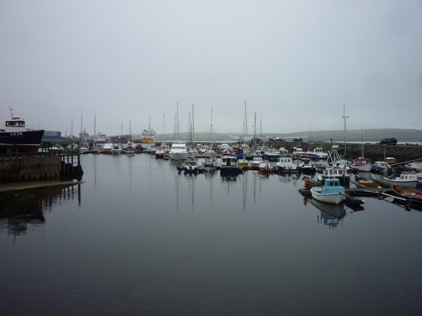
Gremista Marina and Lerwick town docks

So, we had arrived in Shetland and had only a short time before Kyle had to depart for work. We managed a bright sunny day together to tour Lerwick (the capital). Originally we docked in the town harbour, very convenient but with the boat club currently undergoing major renovation there were no real facilities. Since we had to stay for a while, it was suggested we contact the nearby Gremista marina (a community run facility for the locals) to see if they had space for us. Yes they did and at £15 a week it was a bargain despite being two miles out of town, and without shower or toilet facilities. Those two miles I would know intimately by the time Kyle finally returned from work; all good exercise!

Together we did a basic tour (wander) around Lerwick and managed to get a private tour of the Town Hall with its amazing ball room and stained glass features.

The picturesque “Lodberries” were built in the 17th and 18th century as landing areas for local merchants’ produce, with warehouses and dwellings they provided a (relatively deep draft) and a loading area for supply ships. They were designed to save the need to row produce to and from anchored boats in the bay. They were also heavily associated with smuggling to avoid customs duties, and more recent excavations in the area have discovered a significant number of tell-tale tunnels to support the legend.

As we explored the local fort, we found ourselves intruding on modern day military training for the local cadet force; it was a bit peculiar looking at ancient cannons with real machine guns in the vicinity. As we explored the town, we found ourselves in narrow alley ways, and climbing and descending a multiple of old stone steps, it was fun to explore without any particular aim, and we found ourselves disoriented (lost) several times, although it’s such a small town, that feeling never lasted too long.

We finished our day trip with a visit to the FANTASTIC Shetland museum, only 3 years old, it houses a fantastic collection of artifacts, with great story telling and information all to hand. It is also free, and has plenty of activities for young children to fully enjoy the experience too. To top the day, they have an excellent café/restaurant at which Kyle and I enjoyed a splendid lunch before exploring the museum until it closed. It’s the best museum I’ve been to in a long time and we thoroughly recommend it to any visitors. Some of the display boards included some beautiful poetry, and when I later enquired as to the poet the staff instantly knew who I was talking about and recommended to me a publication that includes his work. [Name: T A Robertson, Most famous work "Vagaland", Died 1959, and you can find his poems and others in a book (no longer published) called Shetland Anthology] Having researched further his work is in a heavy Shetland dialect, although the quotes in the museum didn’t seem to be.

I joined Kyle on his trip to the airport on the South end if the island, only for the pair of us to hang out all day awaiting fog to lift and hoping for space on any of many flights. Eventually we had to give up and Kyle had to return really early the next day, this time making his flights and connections without hassle. With Kyle safely off to work, I set about getting the boat ready for our next leg and 2 weeks in the very expensive Norway… Laundry, grocery shopping, and topping up our Propane and fuel – each requiring a hike of some distance; such fun! Of course it wasn’t all work for me, and I managed to do some exploring of my own, including meeting up with a couple of local gals for a nice Indian curry evening, and some great chat.


Clackimin Broch - Lerwick

Brochs are Iron-age, round, windowless, tall, double walled, dry stone, mutli-floor structures found throughout Scotland, especially on the islands to the west and north (are you following me so far?). The walls are often at least 3m thick and it is assumed these performed a defensive role, i.e. impressive buildings. Shetland is thought to have had 100’s, many in sight of several others, and most remain now as just a few feet high of wall structure (with nearby clear re-use of the original stones), many other grassy mounds are identified as most probably old brochs, but yet to be uncovered. The broch of Mousa (one of the Shetland Islands), is one of the best preserved anywhere and its walls still stand to 13m (44’), not bad for a 2000 year old building! In Lerwick, Clickimin Broch sits almost totally surrounded by a small lake and is open to anyone to wander in and explore, it was also directly in between the place I did the laundry and the Tesco store, so I had plenty of time to enjoy it.

Practically the nearest building to themarina is also a museum, the Gremista Böd (fishing hut), and impressive 2-story stone home used to store and process fish, and house the local record keeper. A local guy called Arthur Anderson was born here in 1792; he became the founder of P&O ferries and with no children of his own granted the Islands of Shetland a million kindnesses, indeed funds from his legacy to Lerwick live on to support modern day elderly. The highlight of the böd tour though is the salty character that is there to give you as much information as you need. Also (temporarily) housed in the böd is the textile museum, so I got to feel inferior all over again by the garments of both the ancient and the modern day knitters and lace makers.

Most of the time Kyle was away was filled with very drizzly days, not pleasant at all. Eventually my chores were finished and Kyle was due home in the late afternoon. I decided I’d head back to the south of the Island to meet with him, and spend some time in the morning exploring its tourist offerings on a rare sunny day.


Scatness

First I went to Scatness to see another broch. Evidence of the structure was unexpected discovered in 1975 during construction of the new airport access road. It was left until 1995 and was expertly excavated over 12 years revealing medieval, pictish and iron and bronze age structures on the site (even newer structures exist close by as croft houses, so clearly the site has its advantages whatever the era). The site alone is impressive enough, but the £4 ticket price includes an excellent guided tour by an professional and very knowledgeable archeologist (I had a personal tour as the only tourist at that moment), and various “living history” re-enactments of the crafts of those who may have live here long ago set in reconstructed buildings, based on those found at the site. It’s easy to spend a day there, but I was on a schedule.


Jarlshof

Jarlshof is another ancient multi period site(Stone Age, Bronze Age, Iron Age, Pictish, Norse and Medieval eras, right the way through to the 1600s), mostly uncovered after a severe storm. A similar site in Orkney (also discovered after a storm blew away the sand covering it) is Skara Brae, much more famous, but no more impressive than Jarlshof. This site visit comes with a audio tour allowing you to wander around at your own pace, and learn about the various sites (nice, but not as good as the personal tour in Scatness).


Sumburgh Head

The final attraction of the area is the lighthouse and bird observatory at Sumburgh Head (Sumburgh is pronounced sum-borough, just like Edinburgh). The Norse name for the headland translates to "The Head onto the Thunderous Noise", and it’s not sure if that refers to the pounding sea, or the masses of sea-birds that nest there. The Seabirds are so well known it is a bird observatory too, and home to great numbers of puffins, kittiwakes, razor bills and all the usual suspects of the region.

I just about made it to the airport before Kyle landed (it was a long walk and a close call), and since he arrived almost 2 hours before the bus north, I dragged him to just one site, Scatness, to enjoy a tour too. We again got an excellent private tour – such value!

That wraps up our brief tour of Shetland, but if you are still interested there follows a few more random tid-bits about the area and its history

We were not in Shetland at the right time of year, but others may know it for its famous “fire festival” in mid-January, the “Up Helly-Aa”. A pagan/Viking festival to welcome the longer days, a replica longboat is burned, torch processions march through the streets, and old fashioned entertainment abound in this 3 day long festival. Most of the Shetland towns hold a version of it, but Lerwik’s is the most (in)famous, and sexist of the lot – a great reason to visit in the winter.

Lerwick (actually Gremista) is also home to Europe’s largest pelagic fish factories, and there is a busy traffic of GIANT fishing trawlers. The fish processed here are exported all over the world and are (apparently) known as the best available.

Most of the boats visiting Lerwick stop in the town harbour, and the majority seem to be Norwegian. Granted they are relatively close to Norway, but the main attraction is the cheap booze! Norwegian alcohol purchases are heavily taxed and prices are about triple what a Brit (already relatively heavily taxed) might have to pay, for boats that sign a declaration that they are leaving the UK, alcohol is available to purchase duty-free at amazing rates, and this makes a trip to Shetland very attractive for the modern day smuggler (if they go over their limit, that is, which most happily do). We were very tempted by some of the duty-free rates, but also aware that we were already at our legal limit, so had to decline.. We may well regret that decision, ho, hum!

In 1886 Betty Mouat set out to Lerwick to sell knitted items. Roads then were not what they are today, so Betty (like most folks) travelled by boat (50 foot sailing boat, called the Columbine in this case). Unfortunately the skipper fell overboard en route, and the crew, who jumped in to save him, then lost contact with the boat. For eight days Betty Mouat lived on some ships biscuits and a bottle of milk, before the boat ran aground on the coast of Norway. Betty returned home a minor celebrity and was even sent a letter by Queen Victoria. We’d be thinking of Betty a lot on our pending trip to Norway.

The airport is one of only two in Europe where the runway crosses the main road (the other is in Gibraltar).

Lerwick seems unbelievably prosperous compared to the other highland and island towns we’ve visited. Indeed the whole of Shetland has been impacted by the discovery of North Sea oil, and the need for somewhere to bring that piped oil ashore. The Sullom Voe terminal was built in Shetland amid much local protest (the largest building site in Europe, ever! Excavating enough earth to cover London 1m deep). However the islanders were canny, and insisted on a share of the profits, these have been used to fund several separate community trusts (amenity, recreational, charitable). It is as a result of these trusts that Shetland has its great museums, leisure centers, etc. It also has half the unemployment rates of Scotland as a whole.

Still with me? Gees, then enjoy a wee dram and think of us :-) You deserve at least a good drink.

Thursday, May 20, 2010

Shetland - Main Island


Hitch-hiker on our way North on way to Shetland Mainland

Passing around 60 degrees North

[Kyle]We reluctantly left Fair Isle for Shetland the next morning. The wind started out as a brisk beat to weather on a port tack in sloppy seas. As the day wore on, the wind clocked around and died off until we were eventually ghosting into Lerwick harbor going dead downwind at only a couple knots. As we sailed up the east coast of the Shetland mainland, we passed a big milestone; 60 degrees north. That put us 2635 nautical miles north of the latitude of our southernmost point so far, Jacques Cousteau National Park in Guadeloupe.

Lerwick was pretty full when we arrived and we had to raft up to another boat to get ashore. We found two boats we had met in Fair Isle plus the Australians we had berthed next to in Wick. Perhaps a big reunion is in order, but for now, it’s been a long day so we’re off to sleep in the twilight of the short northern night.

Puffins!


Puffins

[Kyle]For day two in Fair Isle, we pretty much decided to see everything we hadn’t the day before. We started by going to an area known to have Puffins. Puffins like to nest in ex-rabbit holes at the top of cliffs with a view of the sea so they like the thin layer of dirt on top of the rocks preferred by other species. We were just strolling along on the perfectly manicured (by sheep) lawn at the top of one of the sea cliffs, when we saw a couple of Puffin heads poking above the edge with their adorable permanent look of surprise. We were able to slowly creep up to them and then sit on the grass as close to the edge as we dare and just watch them.

It always amazes me in this world of jet planes and internet just how agreeable it is to spend the day doing something slow and simple like sitting in the grass watching birds go through the process of building a nest just right or ambling through a pasture talking to each other and watching the lambs run after their mothers on clumsy legs.

One of the things I learned from sitting there that I never really appreciated was how hard it is to live on cliffs, even for birds. Puffins would fly off to get something to eat or some nice grass for the nest and then have to return. The gusty winds and the topography make this pretty difficult. After a while, we were able to tell who was more experienced at the art. I saw one little guy come zooming up the cliff face and bring himself to a complete stop an inch above his target rock. Then he just folded his wings, put out his feet and plopped right down. The next one tripped over a clump of grass and did a faceplant right into the cliff that was so loud we could hear the impact. Then he had to flap like crazy to keep from falling off the cliff backwards. At a different point, I accidentally flushed a gull off of her egg. She returned to it by landing at the top of the cliff and then doing this mad, stumbling fall to get back. It was the exact opposite of her grace and beauty in the air. She kept landing on her head and messing up her feathers by using her wings to catch herself. It looked like it really hurt. It also looked like that was probably the only way to get to that nest. I felt horrible.

Once we felt that we had disturbed the birds too long, we went to go see the lighthouse on the north end of the island with its enormous steerable foghorn perched on a high cliff. We then went to do what we usually do – climb the highest thing we could see. In this case it was Ward Hill, the highest point on the island at 217 meters (712 feet) From there we could see the southern Shetlands and with binoculars I could just make out Start Point light on Sanday in the Orkneys. I could also see that we were going to have company later; two boats were approaching from the Shetlands and one from Orkney.

We enjoyed the mostly downhill walk through the moorlands on the north side of the island, being occasionally dive-bombed by overprotective Skuas guarding nests we never did see. We arrived back at the harbor just in time to see a Norwegian boat (the one coming from Orkney), rafting up next to a British boat on his way to Norway. We introduced ourselves and offered to help take lines, etc. and in short order were invited aboard for drinks. We accepted, of course, and spent an enjoyable evening talking about boats, Norway, Scotland, each other and anything else that came to mind, all with the beautiful surroundings of Fair Isle in the background.


More Beautiful Fair Isle - including some traditional peat cutting for winter fuel

Exploring Fair Isle


Footprint gets to sail to yet another beautiful new harbour

[Kyle]We had a bit of a lie in and then set off to explore the island. We started by taking the road (actually, there are two) to the lighthouse on the southern side of the island that passed the day before as we sailed in. It was very hard to keep focused along the way because of the spectacular views everywhere we went. The island is gorgeous, and it has cast a spell on me, it is probably my favourite place so far (after Bermuda). Back when I learned to sail on Lake Erie I never even imagined that I would ever someday sail to such a wild and remote place.

Fair Isle seems to have been formed in reverse. The middle of the island is a smooth, grassy bowl with the hills climbing more and more steeply until their abrupt end as high sea cliffs. There are long, narrow inlets everywhere cutting deeply inland, called geos that provided not only spectacular views but also a huge surface for cliff nesting birds as well as grazing for the occasional super-brave sheep. The layers of dirt at the top were riddled with rabbit warrens, some of which had been taken over by Puffins as nesting sites.

Even though the island is only 1 ½ by 2 miles, we covered a lot of distance along the much longer cliff edges and geo rims. This also involved a lot of climbing up to a viewpoint and then back down to get to the next arm of land.

The animals here seem relatively unafraid of humans and, with the exception of Puffins, would allow us to approach pretty closely without fleeing. Several of the island’s sheep and lambs even came running over to us excitedly before apparently realizing we were strangers and wandering off in no real hurry. Although the local skuas did dive bomb us as we (presumably) passed too close to their nest.

[Maryanne]The island is owned by the National Trust (gifted from the previous private owner). The south of the island is given over to crofters. Crofting holds special protective rights; after the atrocities of the clearances, once landlords later tried to clear crofters from their lands there was a revolt followed by a political change that protected crofters and their way of life. For the last 20 years or so the population of Fair Isle has held around 70, and that includes young children who may well continue the way of life. Many locals also supplement their income with crafts (boat building, knitting, spinning and chair making). There are few opportunities for other work, but a local ferry, the post office, school, road repair, coast guard and fire service all provide other part-time employment for the locals. On the North of the Island the replacement Bird Observatory center is currently under construction (on the site of the old center) and will continue to provide accommodation for visitors and volunteers to the island. On our walk we found plenty of capture pens, used to collect the birds for measurements and ringing before release again.

As we’ve mentioned before the biggest draw for tourists to the islands is the bird populations. Kyle and I are hardly expert ornithologists, but it is an easy place to learn quickly. The cliffs are full of sea birds, and we swiftly have begun to recognize the owners of any particular ledge before we even see the birds. The guillemots in particular huddle together, backs to the wind, chest to the wall, on a ledge covered with guano, looking totally miserable while just a few feet away (typically) a pair of fulmars sit comfortably on a clean patch of grass, leisurely looking out to sea and enjoying the sun shine.


Birds and Scenery of Fair Isle - Day 1!

Sunday, May 16, 2010

Stronsay

[Maryanne]Orkney is made up of some 70 islands. I'm not sure how many are populated, and how many are tiny rocks barely exposed at high tide. Somewhat confusingly the main island that is home to the capital (Kirkwall) is called the Mainland. The flavour of Orkney is a little less Scottish that you may expect; it has a long association with Norway, and during WWII had a large population of Italian Prisoners of war, a significant number of which liked it so much they stayed (making Orkney on of the stranger places to get great ice cream!). We've seen more Norwegian boats here than British cruisers, many apparently visit for the duty free alcohol! Most traditional visitors come for the bird watching.


Kyle exploring an ancient burial tomb, and a swan sitting on its giant nest in Stronsay

Unlike the major cities and even smaller towns of the UK, the islands have had much less development during the 1900's, a loss of population, and the remaining population tends to move away from the countryside and into the smaller island towns, with a few remaining farmers hanging on out there. Given this the countryside remains relatively unscathed. Lots of ruins exist, from old crofter cottages, to ancient burial tombs. If these ruins have any protection at all, it is a small ring fence to stop the wandering sheep falling in to any holes. As you leave the main islands, the ruins are no longer presented as a tourist attraction, but are just there for you to discover and explore as you will!

[Kyle]We had a full day on Stronsay to have a look around. Summer appeared to be back, except that it was blowing so hard that anything not tied down disappeared downwind into a tiny point before we had time to grab at it. Never mind, the sky was blue and the low sub-arctic sun was shining.

We consulted our island map and decided to do the big nature hike loop on the other (south) side. The loop was supposed to be 6.5 miles total but it was about 4 miles from Footprint to the beginning along the islands roads. At every intersection, we would carefully get out our fluttering map, work as a team to get a hand on each corner, and decide where to go.

The nature walk first took us to the Bay of Housebay, where we were rewarded with a view of the relatively rare Grey seal (as opposed to the Common seal) doing what all of the animals around here seem to do, which is stop everything they are doing and just STARE at us as we went by. All of the cows along the way had been doing this in true bumpkin fashion and we were finding it a little disconcerting. As we got further and further from farmland, the density of seabird colonies also increased noticeably.


Plenty of birds at Lamb Head

We encountered a herd of sheep grazing on the shore at Lamb Head, another place name that seemed to have been given little thought. One side was smooth grassland, perfect for grazing; the other was steep cliffs, dotted with nesting gulls. We went through a gate in the fence and found another burial ground like Maeshow, but in a more advanced state of disrepair, mostly because the roof had caved in.

We also found one lone lamb that had somehow found itself on the wrong, dangerous side of the fence. We initially figure he’d find his way back in the way he got out, but the poor guy seemed to be having no luck. After a while, I couldn’t stop worrying about the guy and decided to herd him back through the gate Maryanne had opened for him.

Shepherding is hard. The lamb was terrified of me and kept running back and forth along the fence trying to escape me. Eventually, I had to out sprint him in the thick grass to get on the other side so that he would start running back toward the gate. I have a long way to go before I can saunter a hundred of them in the right direction with only the aid of a long stick.

Since our lamb was now reunited with its mother, Maryanne and I shut the gate and headed along the stunning cliff scenery. We startled thousands of birds along the way, who seemed to not see people too often, even though this was the main tourist walk on Stronsay.


Nesting birds on every possible safe place

Our cliff walk eventually terminated at the Vat of Kirbuster, a giant and beautiful natural arch in the rocks that made for a perfect spot to get off our feet and have a little picnic.


Vat of Kirbister - natural stone arch

On the way home, walking on the road past the farms, we spotted on lamb that seemed uncharacteristically unafraid of us. After a closer look, we realized he was caught with his head stuck in the fence. Maryanne went to free him. The poor guy squirmed and struggled like he thought she must be trying to strangle him. Maryanne managed to maintain her cool in the face of it and to get him free. He sprinted over to his mother for some comfort and a meal.

By the time we got back to Footprint, we were pretty tired and starting to limp, but feeling pretty amazed at the great day we had, and the stunning scenery (on a surprisingly sunny day).


Cliff scenery of Stronsay

Beaches too!