Wednesday, February 26, 2020

Wineglass Bay (Tasmania)

[Kyle]From Fortescue, we had an early start for the long sail to Wineglass Bay. The wind was howling and from behind, so we arrived with hours to spare before dusk. Along the way, we had an almost continuous escort of dolphins, who seemed to enjoy our speed. When one group was finished with us, another would streak in, surfing down the waves toward us. I even spotted a little penguin in there with them.


The Sail to Wineglass Bay
near constant dolphin encounters
And a change of geology

Wineglass is high on lots of “Top Things to See in Tasmania” lists. We had also had several other cruisers insist that we shouldn’t miss it. Tour boats come in daily to anchor in the bay while their guests have lunch. One posh weekly boat even takes guests ashore to walk around or lounge in pre-placed beach chairs and enjoy a seafood and champagne lunch. {Maryanne: I'm not sure why this beach is so very high on the tourist info, it is a nice beach with nice trails - but there are hundreds of others that are at least equal to it in my opinion. Still, we were happy to be there}.

Wineglass IS very pretty. Steep hills made of pink and orange granite bookend both sides of a curving, white sand beach. In the morning, our first order of business was to get a better look at it.

We landed on the far end of the 2km long beach from the trail and started walking towards the crowds on the other end. Most of them had done the 4km walk from the car park on the other side of the Freycinet peninsula (all part of the Freycinet National Park).


Royal Penguin

Wallabies - including one we found foraging and munching on mushrooms

We hadn’t even started getting warmed up when we spotted a penguin standing on the beach. He was a Royal Penguin. He was in the middle of a three-week molt. His pin feathers were no good for trapping the air he needs for buoyancy and insulation while swimming, so he just stood there, looking hungrily at the sea. He was as tame as the ones we saw in Antarctica and let us walk (gently) right up to him. He stayed in the same spot for days and it was fun to watch people walking by when they have that moment when they first see him. Everybody we saw was very respectful and didn’t harass him.

We joined the trail for a 16km loop that took us the long, flat way to the opposite side of the peninsula, and then returned over a saddle between two mountains and past viewpoints of the bays in both directions.

As soon as we left the beach, Maryanne spotted a wallaby feeding in the undergrowth. Other than that, we saw a few lizards, plenty of birds and lots of long views filled with interesting geology.


Nice trails and viewpoints

On the final leg, after topping the saddle and leaving the Wineglass Bay viewpoint, we were confronted with a sign reminding walkers that there were a thousand stairs down to the beach and not to proceed if they thought they weren’t up for the return climb.

It was late in the day. We saw a few stragglers chugging their way up the hill on our way down. We got a few, “You know, it’s uphill on the way back” and, “Make sure you get back to your car before dark” comments. The joke’s on them. We LIVE here, at least for today.

{Maryanne: We so enjoyed the loop that a few days later we did it again (but in the other direction); the pictures are a mix from both our exploring days. We also spent time aboard in the mixed weather days and managed to fix the latest rip in the spinnaker among other chores}.

Thursday, February 20, 2020

Fortescue (Tasmania)

[Kyle]We beat the first rays of sunshine to the harbor exit as we headed out. Even so, we were too late and had to dodge around an inbound cruise ship. It looks like Port Arthur is going to be a little more busy than when we saw it.

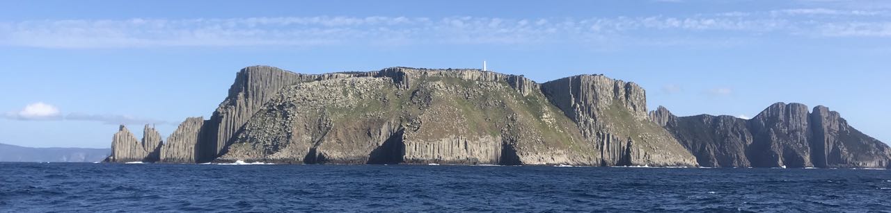
We sailed southeast to clear Tasman Island and then finally started making our way in earnest up Tasmania’s east coast. Tasman Island is an enormous 400-meter high mesa surrounded by near vertical cliffs. Impossibly, in the days before helicopters, they managed to erect a giant lighthouse right on top, which has clear views along the south and east coasts and all of the way up the Derwent to Hobart. Behind it, on the mainland, is Cape Pillar, which rises straight up to 913 meters above the water.


Amazing dolerite columns form the cliffs all along the miles of coast

The scenery around here is incredible. The cliffs are made up of Dolerite columns rising vertically to the tops like innumerable organ pipes. In between are areas of pink or orange granite, adding a splash of color. There are arches and caves galore in the places where the lower rock has given way and fallen into the sea.

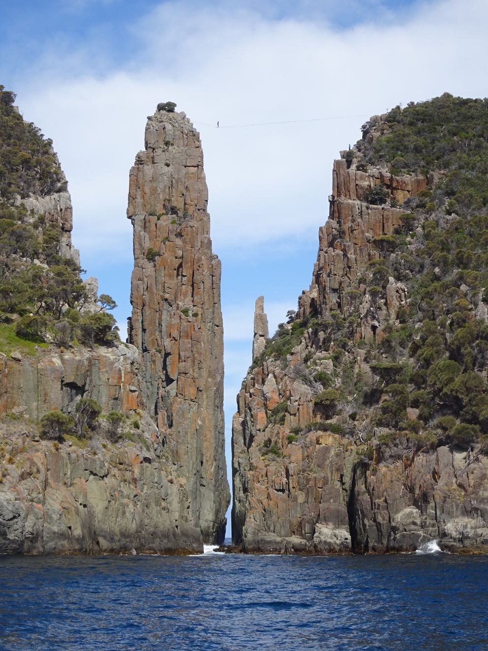
The cliffs continued all of the way to Cape Huay (pronounced 'Hoy'), where we turned inland for our anchorage at Fortescue. Just before we got there, though, we were sailing close under the cliffs at a gap where two dolomite spires rose straight out of the sea. The smaller one is called the Totem Pole. It is a single dolerite column rising to 65m and only four meters wide. It is considered to be the most spectacular free-standing sea stack in the world.

Next to, and towering over the Totem Pole, is the slightly (but only slightly, in proportion) less slender 110m Candlestick. As we passed under it, I noticed a horizontal line connecting it over the Totem Pole to the mainland. My first thought was that it was a power line. We often see this as the electricity source for lighthouses, but Cape Huay doesn’t have a lighthouse. My next thought was that it was a zip line or possibly a line the Park Service uses to traverse the distance for some reason. Above it, we also saw a railing, which was likely the viewpoint at the terminus of a trail.

We watched for a bit and did see a guy at one end of the line who looked like he might be thinking about going across. We don’t know whether he was stopped by a stern sign or just the sight of the sky scraper-sized drop. After a couple of sightings, we didn’t see him anymore, so we continued around to the other side.

This was the side on which the trail ran. We could see several people up there, some milling around, some just sat enjoying the view. We also saw that there was definitely someone there who looked like he was climbing into a harness in preparation for a traverse. We milled around for a while, but nothing happened.

Doesn’t it figure, as soon as we gave up and started moving away, Maryanne spotted the guy pulling himself across, slung under the line, monkey-style. I hadn’t been able to turn the boat around and get back in time for her to get a good mid-chasm photo. It looked like others may be getting ready to head across to meet him, so we hung around some more, hoping to get the shot.

Then Maryanne, who was looking through the telephoto while I was steering, said, “There’s another guy, but he looks like he’s getting on TOP of the rope!”

What!? Time for the good binoculars.


Our life is definitely dull compared to some!

Yup, it WAS a guy standing on top of the line, tightrope-style (technically slack-lining). Then he started walking. He had no pole, so he was just using his arms for balance. He did have a safety line on, but it was not elaborate, only a tether attached to a belt and hooked to the rope behind him with a carabineer. I couldn’t imagine it would be comfortable putting all of the force of a fall on just the belt, or even being able to reach the line from below afterwards.

He walked to the other side, did a little 180° jump over the carabiner to face the other way, and then walked back. Then he did it again, and again. On the third pass, he spotted us, stopped, turned sideways and waved! He seemed completely comfortable up there as if he were strolling down a country lane. We definitely didn’t expect to see that today.

The weird thing was that no one else seemed to care. Of the twenty or so people at the viewpoint, I would have expected to see at least sixteen videoing the whole thing with smartphones. Instead, they were all sitting around looking bored, like they see this guy do it all of the time and just want him to finish so they can go home. Even the guy perched on the Candlestick side seemed more preoccupied with adjusting his gear than watching a guy walk on a rope 110m above a roiling sea (most likely it was a slack-line). Well, WE thought it was exciting!


And then came the dolphins!

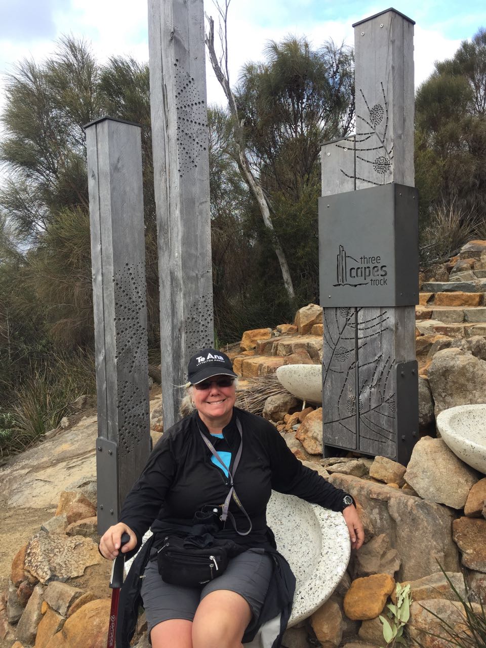
Once were anchored in Fortescue Bay, we had a look at a trail map. There was a trail to Cape Huay right from the campground at the left end of the beach. By the occupancy of the campground, it looked pretty popular, too. Of course, the first thought I had was, “If that guy can do it, so can I!”

The next day, we headed out, ready for a real expedition. It wasn’t necessary. The trail is so well maintained that it’s practically paving stones all of the way to the Cape. We didn’t do it, but it occurred to us that it would be perfectly safe to walk at night with a headlamp. That would be good if you wanted to watch sunrise or sunset from the point or if you just wanted to spot some nocturnal critters.


Walking to Cape Huay (part of the 3 capes track)
Some amazing views as the trail takes us close to the edge

Good shoes weren’t necessary, neither were our hiking poles. I still wore my running shoes anyway. I had plans to fashion the laces into a safety harness if one wasn’t already there for public use.

Imagine my disappointment when we got to the end and found the line was gone. What were we going to do? I did a quick eyeball calculation and determined we would never be able to bridge the gap, even with both of our shoelaces, so we had to content ourselves with admiring the view from behind the railing.


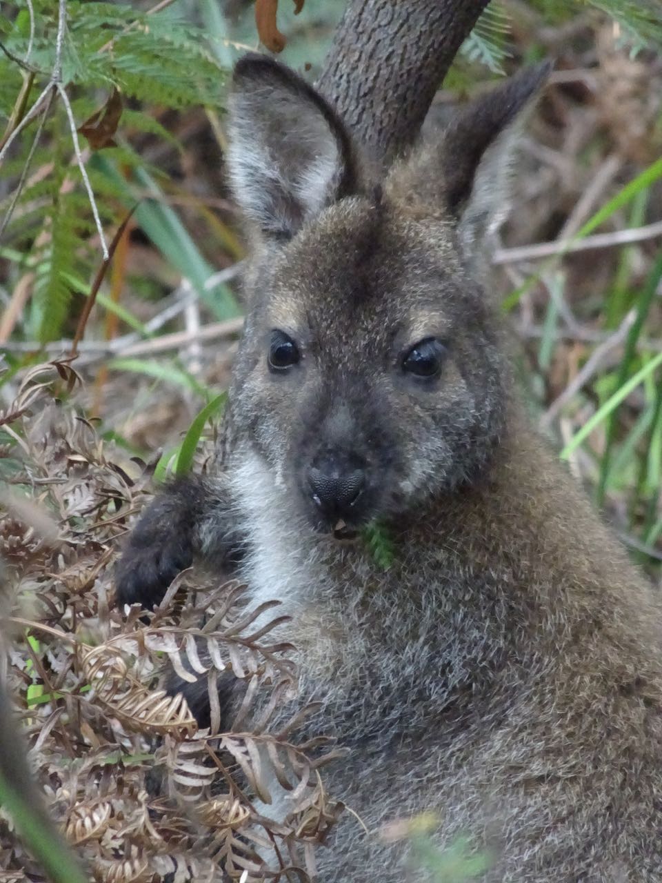
Some of the campers were oblivious to their (Wallaby) visitors

Apart from the trail, the only other excitement we had was when we launched the dinghy into the surf to get back home. We timed it slightly wrong and I got swamped. Maryanne pushed me out into the bay so I could cross the surf line before it got me again. She never made it in the dinghy, so I had to bail out the water and then row to the boat ramp pier to pick her up.

Tuesday, February 18, 2020

Port Arthur (Tasmania)

[Kyle]It took us two legs to get from Hobart to Port Arthur. The wind was variable strength and against us, so we popped into Wedge Bay for a day to wait out the worst of it before carrying on.


Sail via Iron Pot Lighthouse to White Beach


Amazing cliffs and a few dolphins to keep us occupied on route to Port Arthur

The next leg was all tacking, but we still managed to make it into Port Arthur by early afternoon.

We were up early the following morning in anticipation of a full day. We started with a walk across the peninsula to Remarkable Caves. This is a y-shaped tunnel that punches through the sea cliffs to an isolated cove inside. We got there at low enough tide for me to get halfway through for a few pictures without getting too wet. Apparently, at high tide, it’s quite treacherous and during storms the cove is completely flooded with churning water, so I guess we were lucky to get down to water level and see it. {Maryanne: or 'someone' planned it that way... duh!}


First stop ashore was to see the 'remarkable cave'

Our next stop was the historic center at Port Arthur. We stuck out our thumbs in hopes of shortening our walk and were quickly picked up by a lady named Helen, who owned a holiday home in view of Begonia. She dropped us at the door at the museum and then told us to pop in for a beer on the way home.

Port Arthur was one of Australia’s first maximum-security prisons, it was for those considered too bad to be locked up in Hobart (repeat offenders). Hobart was already one step up more miserable than Sydney, mostly due to the climate.


Around the Port Arthur site

Built on a peninsula on the Tasmanian mainland before the construction of a road to Hobart, prisoners were brought by boat to a giant complex that didn’t even have an outer wall. The Tassie bush was too inhospitable, the sea was freezing. There was nowhere to go. The few prisoners that did escape eventually returned starving and thirsty, ready to take the brutal punishment for attempted escape.

When the prison was shut, Port Arthur became home to a mental asylum and then, eventually, a regular old township. Most recently, in its museum status, in 1996, it was the site of Australia’s biggest mass shooting. That one was so bad that Australians all got together afterwards and decided that only very few types of people should only be allowed very few guns each.

Now, on a nice day with big leafy trees everywhere and the bright sun bringing out the warm colors of the stone and brick ruins, it seems like a perfect little Eden. It was hard to imagine it as the site of so much suffering.

We enjoyed the pretty views of the bay on the walk back. At the last road before the beach, we took a right instead of a left and popped in to see Helen. There we met her Husband Steve and their dog, Bertie. Also there was their friend Jason, who was a competitive “over 18” sailor (small catamarans). It didn’t stop there. Another catamaran had come into the anchorage during our day out. Steve had bumped into them and invited them over as well.

Well, it would be hard to wish for more - good company in a lovely, peaceful setting. We talked about Australia, Tasmania, boats, travel...


We were lucky to meet with Helen and Steve during our visit

On the other boat were Graham and Helene. Helene was a long time regional jet pilot for Qantas Link, before quitting to go sailing. Now she is a successful romance/mystery novelist. Romance? Well, at least I had someone with which to trade aviation acronyms.