Leaving Trellis Bay, we were pleased to actually have ideal conditions for our spinnaker as we sailed along the northern coast of Tortola. As we entered the gap Between Tortola and Jost Van Dyke, just about the point where we were outside of Cane Garden Bay, we got a repeat of the same shenanigans we had the last time we left there. This time, by keeping a little north to the Jost Van Dyke side of the direct line, we were able to keep our spinnaker up until we were a mile or so from Soper's Hole.
Here, I was able to land Maryanne ashore and then go loiter in the harbor while she went through the process of clearing us out of the BVI. She had no issue and was back on the wharf waving at me for a pickup within ten minutes or so.
From Soper's Hole, we then headed straight at St. John (Island), U.S. Virgin Islands. Once we crossed the border, we sent a request for inbound clearance to the United States via the CBP ROAM app. This is where it got a little nail-bitey.
To clear U.S. Customs, we might technically have to report to their office at Cruz Bay, which is on the western end of the island, about six miles away. What we really wanted to do was turn the opposite direction to go four miles to the more remote eastern end of the island, most of which is managed by the National Park Service. That way, we wouldn't have to bash upwind from Cruz Bay to get there. Customs and Border Protection have the option of waiving the in-person check-in for those using the app, but they don't have to if they don't like the answers to their questions, they need more information, or just randomly. They can see exactly where we are with the app and may even ask us to come in if our location indicates that we may be trying to avoid coming in.
Sometimes, checking in using the app is a two-minute affair. Today, we had half a bar of phone signal, which would not be enough if they wanted to do a video call, which is common. It took three tries and half an hour to successfully submit our request, during which we shut down the engines and drifted. Then a message came through saying to expect a video call. I wasn't sure if I should have been kicking myself for not having been already halfway to Cruz Bay by now. Seconds later, another message came in saying never mind the video call, you're in. Woo, Hoo! Left turn it is, then.
During our brief transit of the mostly empty hundred meters of water bordering the St. John coast, we couldn't help but notice that the adjoining section of the BVI - Norman Island, The Caves, The Indians - were all chock-a-block today. There were maybe twice as many boats, and bigger ones at that, than when we were there last week. Words like mayhem and pandemonium sprung to mind.
As we rounded Moor Point into Round Bay, I must admit that I was more than a little pleased to see that, in the same area as the sixty moored boats at Norman Island, there was only a single French-flagged monohull. This will do just fine...
Our section of Round Bay, at the smaller indentation of Long Bay, has quite a bit of coral with just a few small patches of clean sand. The French boat was occupying the prime spot we had hoped for near the beach. We poked around a bit nearby, but found nothing that didn't cause us some concern about being able to swing and still protect the coral. We eventually opted for Plan C, which was to head for a big, sandy spot on a seamount further from the shore.
That turned out to be great for us. As a catamaran, the slight extra swell didn't bother us. Also, rumor has it that there is an overly territorial cottager who likes to make the swim to anchored boats to tell them to "get off my lawn!", and then citing a string of non-existent regulations as justification for doing so (we even with the charts and even the Park Authorities in advance to verify this absolutely isn't the case). Begonia's spot was far enough away from the beach that nobody but me or Maryanne was going to bother to make the swim across the gap. It would have been tough to make the argument that, "I was just swimming by and wanted to pass on some helpful information as to why you should be around the corner."
The next morning, sticking close together and towing a safety float to make us visible to tour boats, Maryanne and I swam from Begonia across to Pelican Rocks, where those boats drop off their guests for a snorkel.
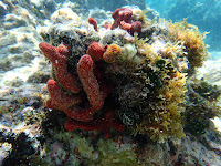
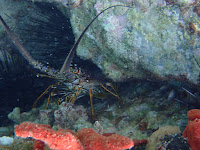
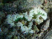
The wildlife was not amazing, but not bad either. The interesting geology of the rocks added to the view, which made the site an interesting place to poke around. Mostly, it was good to have a long swim to get some exercise. After we'd had our fill, which seemed to be about three times the time allotted to the tour boat snorkelers, we joined up again to swim full-steam back to Begonia and our private seamount in time for sunset.
As the light faded, the air filled with the sounds of chirruping insects and birds roosting for the night. Hmm... no generators! Then, in the short interval before moonrise, it got dark - really dark, with no ridiculous floodlights washing out the stars. Oh, yes. So far, we are liking the U.S. Virgin Islands very much.


The things seeen while snorkelling in the East End of St John. That large sliver egg like thing Kyle has in his had is actually a green algae, and the worlds largest single celled organism:Valonia Ventricosa (also known as Sailor's Eyeball)
Anchorage location in East End USVI >> On google maps

No comments:
Post a Comment