Monday, July 06, 2020

Fife Island

[Kyle]The wind forecast for the leg from Stanley to Fife Island turned out to be totally wrong. We left with reefs in the sails, expecting to be pummeled as soon as we left the lee of the island. We had this for ten minutes or so before it died and switched to the other side of the boat, rather than the increase we were expecting.

We didn't trust it, so we waited a long time before we finally decided the spinnaker was warranted.

Once it was up and flying ahead of the mainsail, we had to chase each wind shift in order to maintain the narrow angle between having the wind too far forward to fill the spinnaker and so far aft that it collapsed in the lee of the mainsail. After a mile or so, we finally admitted defeat and pulled the main down and out of the way, which improved things quite a bit.

We had a pretty good five miles after that before we had to gybe the spinnaker over to the other side. Pretty much as soon as it was set, the wind arrived in earnest and we had to go about switching back to our normal white sails. Then we had to reef. Then we had to reef again. At least it was bright and sunny and we had great views of the coastal mountains for perhaps thirty miles in either direction as a backdrop for all of the work.

During our sail, we saw no other boats of any kind. Even coastal shipping, which we can usually pick up with our AIS receiver thirty miles out, was showing nothing other than the base station repeaters dotted along the coast. Usually, there was a ship going in either direction every four hours or so, but today, there was nothing.

We rounded the sand spit at the northwest corner of Fife Island and headed toward the recommended anchoring spot on the long, northern side. The wind was by then howling out of the east, which left us totally exposed there to the building swell. We elected to go back around the sand spit and anchor in the lee of the island on the skinny west side, where the water appeared to be smoother.

The bottom drops off more steeply on that side. As we approached, our depth sounder went: 23..22..21..20..4..3..2½. Aahhh! We dropped the anchor in the millimeter before we hit two meters and backed down to where Begonia was again floating seventeen meters above the seabed. Then we pulled like hell on the anchor to make sure it was set. Whew!

Once everything stabilized, we couldn't help but notice that there was just a wee swell wrapping around our side of the island. It hit us from the south while we were pointed into the wind, facing east. This made for a bit of uncomfortable roll that increased in intensity as the tide rose. Once our protective sand spit covered, our northbound swell crashed into the westbound swell we had come here to escape, making a jumble of pyramid-shaped waves that threw us around worse than being underway at sea. Stuff that never falls over fell over and then off the tables and countertops and onto the floor. By then, it was too late in the day to move. We knew we weren't dragging, so we would just have to hunker down for the night. We went to bed right after dinner because that was the only place that didn't require us to brace constantly to stay upright.

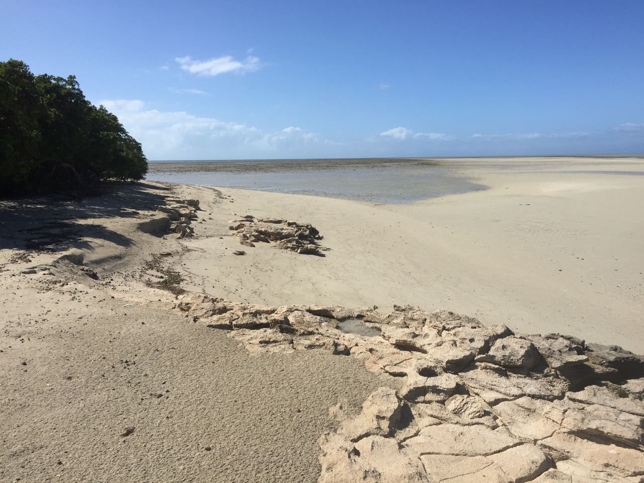
The next morning before we had even boiled the water for coffee, we moved back over to the north side of the island, hoping we could salvage our visit. There was some swell there, but only from one direction and we pointed into it, which was immensely more comfortable. Even better, as the tide fell, a mile and a half long wall of sand reared up in front of us and flattened the sea completely. Oh, that is so much better!

As low tide approached, we lowered the dinghy to head ashore. As soon as it hit the water, a twenty-five knot wind kicked up and churned the sea into froth. The wavelets were too small to effect Begonia, but getting from there to shore ended up being a wet, grueling row, making about a Begonia length of progress every five minutes or so. Oh, if only we had left twenty minutes earlier...

When we finally made it to the sand, my arms were so rubbery from the row that it took me a couple of minutes before I had the strength to help Maryanne drag the dinghy up onto the beach. Time to switch to using our legs.

The sand flats that expose at low tide run for 1.5 nautical miles from the tip of 0.3-mile long Fife Island to the far end. That's most of the way to the horizon. We had better get moving. We chased crabs and spotted birds and studied various shells we found along the way. All the while, we had to shout our musings to one another to be heard over the whining wind. We were hoping it had been a short-term squall, but it seemed to be here to stay.


Exploring the beautiful patterns and critters at low tide (did you spot the "shaggy crab"?)

Back at the island, we did a counter-clockwise circuit, puzzling over various bird and crab tracks along the way. We never found any human tracks. Fife has a single palm tree towering over the scrub. Maryanne had a look at it through the binoculars when we anchored and reported that it was sprouting coconuts! We were looking forward to collecting a few for snacks, but the tree proved to be too far inland to get to through underbrush that was a little too thick. Damn!


And then there is the bird life...
A sandpiper, sacred kingfisher, white-breasted sea-eagle and a satin flycatcher

When we reached the sand spit on the opposite, northwest side of the island, I elected to walk to the end while Maryanne stayed behind trying to scout out another path to the coconut tree (no luck). About halfway to the tip, I came across some interesting tracks and took some photos to show Maryanne. When I got back to her, I handed her my phone and showed her what I had found.

”Ooh! Must be some kind of lizard”

I scrolled to the picture with my hand by one of the footprints for scale. They were both about the same size.

”Maybe a Goana?” (monitor lizard)

”Maryanne, what would a goana be doing crossing from one side of a sand spit to the other?”

That's when it hit her. Crocodile. I had actually found two sets of tracks. One going in each direction. As I was describing them to her, we both came across a third. They went from the water into the high grass behind the beach and then back to the water. The tracks looked to be about the same size as the others. The animal was about as wide as me. I guessed it was probably a meter and a half long. They can grow to seven meters, so our little guy was only cause for slight to medium concern.


Croc tracks - a small one!

Further on, we found a fourth set of tracks. These led into the grass, but did not lead out. Aw! I wonder if the little guy is still in there. Let's check.

Uh, on second thought, let's keep wondering.

The dinghy ride back to the boat was so much easier than going to shore. I only had to row twice to get lined up and then let the wind do the rest. Maryanne kept asking me why I was dawdling. There were crocs out here!

The next morning as I was waiting for the kettle to boil, I scanned the beach with the binoculars. Sitting right on top of the northwest spit was a croc that seemed to be about the size I had guessed before. There he was, trying his best to convince the nearby birds that he was just a piece of driftwood. Nothing to see here, just a piece of driftwood...


From the safety of the boat we did eventually spy a croc ashore

An hour or so later, he was gone. The tracks went down our side. I guess that takes a refreshing afternoon swim off of the table.

Friday, July 03, 2020

Stanley Island

[Kyle]Our next planned stop was a day's sail away at another Ingram-style reef called Clack Reef. It was a picture perfect day for sailing. We did the whole thing in smooth seas using our backup (now primary) spinnaker. Our only real hitch was that the wind forecast was calling for strong winds in a couple of days. Ingram had been a little uncomfortable as the swell wrapped around the island at high tide and we were worried Clack might be worse. We decided to change the plan and divert instead to nearby Stokes Bay at Stanley Island, which looked like it would offer better protection.


Sailing north along some distinctive coast

Our sail took us past Cape Melville and into Bathurst Bay. In the eons since this part of the world was Gondwanaland, Cape Melville has eroded down to what appears to be an improbable jumble of large, rounded boulders that seemed to have tumbled down from nowhere. Since passing north of Cooktown and especially Lizard Island, we have entered a very remote and uninhabited part of Australia. The few roads on the maps are in fact, mostly just seasonal 4WD roads to part-time encampments.

On its face, this seems illogical to me. The northern end of Queensland is by far the closest part of Australia to an enormous contingent of the world's population, most of which is in the Northern Hemisphere. New Guinea is up there as well as the Philippines, Indonesia, China – LOTS of people. It seems like it would be natural to settle there.

But, of course, that's not how it happened. As far as we know, the Aborigines arrived a LONG time ago and since then have not found it necessary to backtrack off of the continent. The second, Western wave began its colonization from Botany Bay, which is in the more temperate, agriculturally fertile corner of the country, way down South. Thus, most of Australia's big population centers, Sydney, Melbourne, Adelaide, Perth, are in the far, southern half of the continent, far away from all of that stuff up north. I guess they figured that they have already come so far, What's an extra thousand miles? Plus, until recently, they have had an official immigration policy that tended to, ahem, discourage people from the nearest populated regions.

The weather can also be a bit of a challenge. Tropical Queensland has but two seasons: Dry and Wet. The Wet is during Tropical Storm season. The area gets so much rain then that through-roads are regularly flooded, cutting off whole regions for months. Thus, Queensland north of Cairns is pretty much the Tropical Outback, where any signs of technological humanity, such as roads and power lines, are very few and far between.

Stanley Island lies in Bathurst Bay. It is fairly large, with a high ridge shielding the anchorage on the northwest side from the wind. A bit further to the south, we saw two commercial fishing boats anchored off of the tip of the island. This sole reminder of humanity would leave at dusk each night and return at dawn after a whole night of fishing. If we ever stirred at night, we could track them by following their lights near the horizon. Since we figured they spent their days sleeping, we had no other contact with them.

From our position at anchor, we couldn't see a whole lot to do ashore. The nearby beaches were small and through the binoculars, I couldn't see any signs of a trail or any other way inland from there. Still, we thought that going ashore would offer a nice diversion.

By the time we finally got around to it, it was almost low tide. That was good because low tide can make for some good photos. It was also bad because it made getting ashore a bit of a challenge.

The tide was low enough that it had gone below all of the sand on the beach and was starting to uncover vast mud flats interspersed with coral. This was a particular problem because Stanley Island was clearly listed as a croc area. These ambush predators are well known for laying in wait in ankle-deep water. Our path ashore required us do leave the dinghy and wade through a hundred meters if mud interspersed with rocks that suddenly all looked like lurking crocs.

We made it safely ashore and, brandishing a long stick each, we headed to the end of the beach. We looked hard, but found no croc slides, so we braved the grasses fronting the sand, using our sticks to beat a clear path through to the following beach.

We repeated this process a few times until we emerged at a long stretch of sand that went on as far as we cared to go. We knew it would be a while before the tide fell and then rose back to the level of the dinghy, so we kept walking further and further in the midday heat until reaching a sensible turnaround time. We saw lots of interesting geology, but there were few animals out cavorting to entertain us.


Ashore we found a cruisers corner, and a host of spiny-lobster carapaces


After a good explore ashore - Kyle went up the mast to fix the wind indicator

When we finally made it back to the dinghy, we were spent, mostly from the heat. Since we hadn't thought there would be much to do ashore, we hadn't taken any food or drink with us and we were both having fantasies about the refreshments we would find when we finally made it back to Begonia.

We got back home just as the fishing boats were leaving for the night. They started work while we were winding down for the day. I awoke the next morning while they were still out there, but getting closer. By the time they had set their anchors, we had pulled up ours and were on our way to the next place.

Wednesday, July 01, 2020

Ingram Island

[Kyle]After a couple of days at Lizard Island, we left at first light for the sail to Ingram Island. There was plenty of wind and it was from almost dead astern, so we merely had to unroll the jib and watch the miles go by. We were hoping we would see more dolphins and whales, but they never came by. Most of the journey was in fifteen to twenty meters of depth, so maybe it was a bit thin for them.

We weren't expecting much from Ingram. The anchorage is basically in the lee of the island, which lies at the corner of a much larger reef that connects with other nearby islands. Ingram is a few hundred meters long, so we planned to go ashore and do a lap of the beach.


The location was pretty. Ingram is much closer to the mainland than Lizard, which covers the western horizon with a range of steep mountains. In between, several other islands filled in the space, which made for a nicely varied view from the boat.

We went ashore at low tide, which at first seemed like a really bad idea because it was difficult to find a route to the beach that didn't require wading a long way through the shallows. We were aware that there weren't necessarily no crocs around, so we were eager to minimize our time in shin-deep water.


After pulling our dinghy up high enough to allow for the rising tide, we started our walking circuit of the island by going counter-clockwise. At the back side of the island we found a bounty! Almost the entire space between the islands fringing Ingram Reef was filled in by sand flats. Sort of in the manner of Pancake Creek, we had almost a square mile of hard sand on which to perambulate. There wasn't a whole lot to see, but we did find lots of interesting shells and spooked a few crabs into their hidey holes. Mostly, it just felt good to open up and walk some real distance at a brisk pace. We did so because we knew we only had an hour or so before this would all be under water again.


When we got back to the island, we resumed our circuit along the beach. We poked around in lots of tide pools and disturbed a few birds unaccustomed to seeing people. Afterward, we dove inland to see the interior. There, we found even more birds, including a few Varied Honeyeaters. There must have been a few gull nests around, because these birds were regularly dive-bombing and squawking at us. We tried to be very aware of where we put our feet, but never found any nests in the interior. We did, however find a fluffy little chick swimming in the shallows by the beach.

In all, we spent three hours ashore, after originally thinking we might be back in under an hour. The wind was really picking up by then, so getting back to Begonia and getting aboard was a real time-it-and-jump affair. From the boat, we enjoyed the twice-daily spectacle of watching vast areas of sand change into vast areas of sea and back again. Apart from a few distant ships making their way up and down the shipping channels, we saw no other signs of humanity for our whole stay. Ingram turned out to be a very peasant place to pass a couple of days.