Thursday, May 29, 2014

Hello Maui

[Kyle]At first light, we left Nishinmura (and Big Island) behind and headed north-northwest to Maui to cross the 'Alenuihaha channel. The skies were clear and once we cleared the cliffs of the anchorage, we could see all the way to the observatories at the top of Mauna Kea. Maui’s dark slopes thrust skyward in the distance much more steeply than the gentle pastures of Hawai’i behind.

The wind picked up slowly and we had a nice, fast sail across the channel that has the reputation of being Hawaii’s worst. At the other side, we could see the uninterrupted Pacific swell crashing into the cliffs ahead at the base of a large lava flow. It wasn’t until we got in close that we could see the indentation at Nu’u, tucked out of the swell behind a tongue of a’a lava and ringed by a beach of black boulders.


Nu'u landing on the mid-south coast of Maui and it's amazing landscape

This is where we will spend a few nights! The steep green slopes rise into even steeper crags that disappear into the clouds above. Waves hit the a’a tongue to the east and explode into spray, leaving only a gentle, rock-you-to-sleep remnant that passes through the bay, steepens sharply and crashes onto the boulders of the beach. It’s marvelous! The pounding surf hits the beach with a boom of white foam, which flows back through the boulders, sounding like distant thunder.

I had a swim to check the anchor. The visibility isn’t great with all of the silt being churned up, but the anchor is well buried in fine black sand that clumps together like paste when you squeeze it. The a’a blocks the swell, but not the trade winds, so our wind generator is putting out plenty of power. Despite there being no phone signal (or internet), Yes, I think this will be a great spot to spend a few days resting up.

Farewell to the Big Island

[Kyle]After Kealakekua, our next planned stop was a short way up the coast at Honokohau harbor, just north of Kona. I hadn’t been really looking forward to it, since our guides said it was neither nice, nor terribly convenient, but we needed to break up the journey to the northern tip of the island and Honokohau was the last decent stop. Maryanne looked at the guide books and decided she would rather do the whole trip north as one long, overnight leg. So, instead of going to bed, we pulled up anchor and sailed out of Captain Cook’s bay in time for a sunset at sea. We actually got a better one than they did back in the bay because we had sailed far enough offshore to be clear of the clouds over land.

Again, as we had from Honomolino, we pinched as close to the wind as we could on a course perpendicular to the shore. After the requisite couple of hours, we tacked and right at the same moment, the wind stopped completely. We bobbed around for another hour before we could even get Begonia pointed the direction we were trying to go, much less moving that way.

Once we were finally moving steadily, I handed the boat over to Maryanne and got a few hours of sleep. When she woke me, I learned that she had suffered a repeat of my frustrations and had only made it eight miles, mostly by drifting. Oh how I longed for the trade winds on the eastern side of the island.

As the sun came up, we were heading straight into Kailua Bay at Kona, only twelve miles up the coast from Kealakekua. We should have been twenty miles further along by then. I was starting to worry we wouldn’t make it to our anchorage by nightfall.

We tacked away from the coast and after a few minutes of bobbing around, a wind finally came in from the west. We were able to parallel the shore as our boat speed hit seven, then eight, then nine, and then ten knots. Whoo, hoo! That’s more like it.

All frustration was soon lost when our speed picked up AND we had a pod of bottlenose dolphins join us for a ride. They never fail to bring a smile to any face.


Bottlenose dolphins join us on our passage north off Big Island

Soon, we were approaching the two-boat anchorage at Nishimura Bay near the NW tip of Hawai'i island. I couldn’t spot any other vessels through the binoculars, but then suddenly another sailboat started peeking around the headland and then disappearing again as it swung around its anchor in the shifting winds. In the distance was a monohull that appeared to be heading across the Alenuihaha channel towards Maui. They tacked and were soon right behind us for Nishinura.

We passed the other anchored boat, which was a grubby derelict, rolling wildly in the swell, and picked a spot on the far end of the sand patch as close as we dared to the rocks on shore, trying to leave room for the other boat headed the same way. They came pretty close under sail and tacked away. I could see at that point that it was Rachel and Adam from Moments.

I got on the radio and told them we thought we left enough room for them on the other side of the sand, but that if they didn’t like that, they were welcome to tie up to us for the night. Our anchor was well dug in. They thought for a moment and then told us thanks, but they were going to go directly to Maui instead.


Nishimura Bay for a quick overnight break on route. The hilltop is home to an ancient Hawaiian heiau (A mini Stonehenge used as a navigation marker). And even a boat full of junk can look good in the sunset!

I can’t say I really blame them. Nishimura was really small and seemed to offer little protection from the swell. I had pictured a little jewel of a cove like Honomolino, but it’s only redeeming qualities seemed to be good holding and a view of Maui in the distance. That would have been pretty cool if it weren’t for the boat full of junk in the foreground. I had originally thought we might stay until a lull in the strong trade winds a few days later, but we decided to make the crossing of the Alenuihaha first thing the next morning before they picked up.

Kealakekua Bay

[Kyle]Leaving Honomolino, we headed as close as we could to the wind on a course that took us directly away from the island. We sailed eight or nine miles out, where Hawai’i was just a thin line in the haze between the horizon and the clouds covering most of it’s top. We tacked, and for the next few hours, we slowly angled in on Kealakekua Bay.

Kealakekua has reputedly the best snorkeling in all of Hawaii. Because of this, it is a marine conservation area with some pretty strict rules. We were reviewing our various guides on approach, when Maryanne noticed a sentence that said something to the effect of, “The rules change frequently, so check with the harbormaster in Hilo for updates.”

She decided to play it safe and embarked on a long telephone treasure hunt as she called one department or another before being directed to the next one. Now able to see into the bay around the intervening headland, I couldn’t help but notice that there were no other boats in the anchorage at this prime destination. I started to worry that anchoring was no longer allowed.

Maryanne finally managed to reach a woman at the State Parks Department, who informed her that we could anchor only with a permit obtained in advance. Undaunted, Maryanne asked if they had an online application. Indeed, she suggested, she would email us the paperwork and if we were quick about returning it, she could process our permit within the hour. Marvellous!

We got a few suspicious looks from the balconies of the houses on the bay front at the village of Napupu as we came in and dropped our anchor in the sand off of the village, being very careful to stay away from any coral. Once we were settled in, they went back to their usual business of being somewhere really cool in Hawai’i.

We were up before daylight the following morning in an attempt to beat the groups of snorkelers brought by tour boats. One of the many conditions in the small print of our permit was that we could not launch a boat from the permitted vessel. This meant our only option was to swim the mile or so across the bay from our authorized anchorage area to the main area of reef on the other side.


Arriving in time for sunset and then to enjoy a full day of snorkelling

We didn’t get far from Begonia before the sand below retreated out of sight. We spent most of the way swimming over a blue void. It was easy to get disoriented, so we would check our heading every ten breaths or so by popping our heads out of the water to see that we were still heading toward the obelisk on the other side marking the location of Captain Cook’s death. Kealakekua was also the first place he landed and thus the site of the first contact between Hawaiians and Europeans.

Of course Captain Cook has a significant history of his own (although a little mixed in Hawaii). We've read numerous books about his voyages and it was cool to think we were somewhere that he had been (indeed, the place he died - at the hands of some pretty upset Hawaiians!).

We were very close to the rocks on the other shore before the seabed thrust upward in an explosion of coral and colorful fish. We followed the ledge to the point and then turned back over the shelf around the entire curvature of the bay until we had finally made it to the rocks between Napupu and Begonia.

There is a lot of healthy-looking coral in this bay. We had read that the Kona coastline (of which Kealakekua is a significant part) has 57% of Hawaii's coral, and Hawaii itself has 75% of all USA living coral. Instead of the odd clump here and there, there were whole fields of the stuff.

It was early afternoon by the time we made it back on board Begonia. We hadn’t had anything since our breakfast of a granola bar each, so we were pretty tired and hungry by then. We had an early dinner and then popped in a DVD that we bought at the ‘Imaloa gift shop about the last of the Polynesian navigators. Polynesians managed to navigate (regularly) 1000's of miles using their own system of stars, currents, etc - we were keen to learn what we could of their ways.

On that very DVD a scene came up showing an etching of Captain Cook’s ship and crew meeting with Polynesian sailing canoes. The location looked really familiar. We looked at it, and then at each other and realized; That’s here! The perspective was the exact same one we had from our cockpit, only zoomed out. It was probably drawn from the beach behind us. Captain Cook’s fleet of big ships was anchored in the deep water in the middle of the bay. Polynesian outrigger canoes were ringing the shore and the larger sailing catamarans were in the shallower water by the village. One of them was right in the spot our catamaran was currently anchored. Well, how about that?

Thursday, May 22, 2014

Honomolino Bay

[Kyle]We left Hilo midday for Honomolino Bay, on the west side of the island. The trip is long and we knew it would be made even longer by having to tack the first twenty miles to get around Cape Kumukahi, on the Big island’s western tip.

It took us from noon until midnight to make it to the Cape. Afterwards, we were expecting to have a nice, fast, downwind ride in the trade winds, but it never materialized. It was the time of night when the cool winds running down the hills slowed the opposing trade winds to a crawl. We spent most of the seventy-mile leg rolling back and forth in the swell. It wasn’t until we passed Ka Lae, Hawaii’s southernmost point, that we finally got to go fast. We also never got to see any lava flowing into the sea. The flows are pretty dormant at the moment.


Rounding the point before sunset in the volcanic fog (also known as VOG)

We made it to Honomolino just as it got dark. Honomolino is a small, unmarked bight along a coast of rugged a’a lava just big enough for three or so boats. We were the second one there, along with a couple from Seattle who had also sailed from Hilo only a few hours ahead of us.

In the morning, we got a real treat. I was making coffee when I spotted dolphins. I tried to focus, but eventually ended up leaving the pot to go cold as we went in for a swim with them. They were Spinner Dolphins. Spinners feed in deep water at night and hang around in shallow bays nearby during the daytime.


Spinner Dolphins hanging out both days at the anchorage - Wow, just wow!

The best part was in the afternoon, when the dolphins started getting energetic. Now we know why they’re called spinners. They love to do crazy, acrobatic leaps out of the water! There was one young one whose favorite move seemed to be a double flip with a triple twist. Maybe it’s fun for them to get dizzy. Maybe they’re showing off for each other. It was sure a lot of fun for us to watch them.

Adam and Rachel, from the other boat, Moments, came over afterwards for dinner. They were going to leave that afternoon, but decided the dolphins were just too good to leave. We had also decided to stay an extra night for the same reason.

Once they left the next morning, a few tourists visited the bay during the middle of the day. By afternoon, we had the whole beautiful remote place to ourselves, where we swam to our heart’s content, sometimes even with the dolphins.


What a treasure of a bay!

Wednesday, May 21, 2014

Hilo Museums

[Maryanne]With our days in Hilo shrinking, it was time to use up the last of our taxi vouchers and spend more time downtown before moving on to other places on the Big Island.

We visited the Tsunami Museum, dedicated to educating about (and hopefully preparing folks for) the way too regular catastrophes that hit Hawaii. There is a tsunami well overdue, and we learned that depending on the source of the quake, we may have just minutes rather than hours to evacuate - gulp!


Kamehameha The Great, and the Tsunami Museum on the Hilo waterfront

With free entry, the Mokupapapa Discovery Center was a hidden gem, a few excellent exhibits shown in a giant space that even included an aquarium.

Along with all this new found insight and education, we ducked out for a $2.50 cinema ticket to see the Lego movie (oh, yeah, we are so, so, trendy!

[Kyle]The last thing we managed to do in Hilo was visit the ‘Imiloa Astronomy Center in town, thanks to the generosity of our friend Warren, who is a telescope and site researching astronomer for the new Thirty Meter Telescope (construction is scheduled to begin on Mauna Kea in August).


This one exhibit in the 'Imiloa Museum (a big tube of sand) states "Each grain of sand represents one atom in your body. Now imagine 10 million times more sand. That is how many atoms are in just ONE of your eyelashes!". Science Rocks!

We spent the whole day there immersing ourselves in really well done displays that blended science and Hawaiian culture. Maryanne and I were particularly interested in the ancient Polynesian systems of navigation that used the night sky as a compass for their far-flung voyages. We had been heading at the constellation of Gemini pretty much the whole way here. When we got to where the star Arcturus was straight up, we were at the latitude of Hawai’i. The Polynesians did a more sophisticated version of that, plus a careful reading of the swell to sail all over the Pacific.

We had intended to eat at the restaurant there in order to make up for our admission savings, but there was a wedding going on and it looked like we were going to be the only ones not in the party. We headed to the gift shop instead.

Fun on the Water

[Kyle]We don’t have much, but we have a boat, so as a thank you to Doug and Catherine we tortured them by taking them out into the open ocean on a sail aboard Begonia.

We beat to weather for a few hours and then turned back for a smooth, downwind ride into Hilo harbor. No one got sick and they even claimed to have a good time. They’re so nice.

We dropped the hook almost in our old spot in Reed’s Bay, and then stayed up late eating and drinking and talking. Doug even brought us some of his award-winning mead to sample. It’s pretty good stuff – so good in fact that I may not have realized how strong it was and had a bit too much. The next morning, I had another first – a mead hangover. It wasn’t terrible, but it’s still not recommended.

{Maryanne: I can't believe we took no pictures, but it is probably for the best since my hangover lasted quite some time!}

Mauna Kea Observatories

[Kyle]We rented a vehicle again. This time it was a four-wheel drive, so we could take the very steep road up to the summit of Mauna Kea.

My thought for most of the trip to Hawai’i was that we couldn’t sail all the way here and not go to the top. Maryanne pointed out that there were lots of other goals, like beaches and volcanoes and petroglyphs to be seen, also competing for our rapidly diminishing time in Hilo and requiring a car. When she found out four-wheel drive prices are triple, she really lost interest. She made a good argument. Mine was just that I didn’t care if it was cost effective, I really wanted to go. I think she eventually gave in because she knew I would have us trying to walk there from the boat otherwise as is our custom.

Per Wikipedia: Mauna Kea stands 13,803 ft (4,207 m) above sea level, its peak is the highest point in the U.S. state of Hawaii. However, much of Mauna Kea is below sea level; when measured from its oceanic base, its height is 33,100 ft (10,100 m)—more than twice Mount Everest's base-to-peak height of 11,980 to 15,260 ft (3,650 to 4,650 m)

As a bonus, our friends from Hilo, Doug and Catherine, had never been to the top either as none of the vehicles they have had during their tenure has been suitable.

After being treated to a nice Thai curry take-out, we all piled in, along with snacks and warm clothes and headed upwards. We stopped for an hour or so at the visitor’s information center at 9,200 feet (2,800 meters) to go for a short hike to a nearby viewpoint in order to help acclimate ourselves to the altitude.


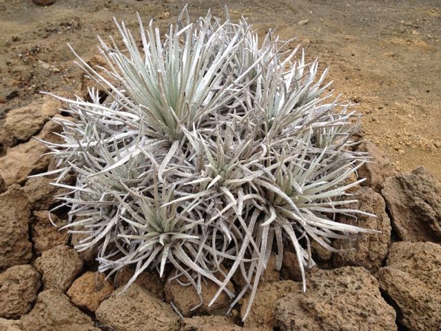
The rare and fragile Mauna Kea silversword, Argyroxiphium sandwicense

Almost as soon as we started hiking, we were enshrouded in thick fog. So much for the view! We instead turned our attention to the fascinating geology at our feet. Although there was a whole ecosystem of plants and animals that have taken root since the land was formed, erosion is a very slow process and the place still feels as if the lave had only just stopped cooling.


Acclimatising to the altitude with a short hike up a cinder cone

We bundled up, engaged the four-wheel drive and headed to the summit. About halfway from the visitor’s center, we climbed out of the fog into a brilliant clear sky. The dry landscape above the tree line made us feel like we were climbing Olympus Mons on Mars.


The road up, and up, the mountain..

We parked the car between a couple of the observatories and got out for a look. Walking along the access road, it’s impossible not to be impressed by the collection of some of the world’s largest observatory for optical, infrared, and submillimeter astronomy. I was surprised by how small most of them were. I guess I had pictured something the size of a planetarium with a few offices to one side. Instead, most seemed only big enough to hold the telescope, plus maybe a small desk underneath.


The views from the top - that is some FANCY equipment!

Me being me, and Maryanne being Maryanne, we had to do the short hike up a steep path to the true summit of Mauna Kea, separated from the observatories by a small crater and standing at 13,808 feet (4,208 meters). Although I have climbed a few mountains over 14,000 feet and as a kid growing up in Colorado, it’s been a very long time since I have exerted myself at anything near that altitude in a very long time. I haven’t even been in an airplane for a while, with its equivalent pressure altitude of 8,000 feet. Although we could definitely feel the strain of each step more than at sea level, I was actually surprised we weren’t more tired. Perhaps it was the cool air, perhaps it was the view, but we almost had a spring in our step as we topped the mountain.


A walk to the actual top - for the views!

Wow! Although most of the Big Island was beneath the clouds, the sea was visible below. Most of the 14,000 foot mountains in Colorado rise above a 9,000 foot plain, so there isn’t so much of a sense of being waay up there as there was here, looking down on a steep landscape of volcanic rubble in the long shadows before dusk. Maryanne then conceded that it was totally worth it to come up here. I must admit, it was even cooler than I thought it would be. I am so glad we didn’t skip it.

We descended an even steeper path down the other side of the crater rim to a spot below where we had parked and then walked up to meet our friends. We got there just as the sun set and then retreated to the warmth of the car, where we ate a dinner of energy bars and snack food as the stars came out.

A very nice ranger came by and told us we should be on our way. He did it in such a diplomatic and non-confrontational way that we were all thanking him profusely for his concern when I started the engine to leave.

We stopped again at the visitor’s center on the way down, where they had lots of telescopes set up in the fog. The staff said this happens nearly every night, but it usually clears. In the meantime, we went inside to watch a video about the observatories and the mountain as a consolation prize.

I did clear up eventually, and we all got to see a couple of planets and a star cluster through breaks in the clouds before leaving. It was a work night for Catherine, so we called it a night and headed back down to the thick, warm air at sea level.

Thursday, May 15, 2014

Hawai’i (Big Island)

[Maryanne]After fully resting with a couple of days on the boat enjoying the views, we ventured into Hilo to visit the market, and waterfalls... It turned out to be a long walk!


Some interesting art in the local park, and a scene from the market


The local post office and library are open to the elements, quite novel, and the library seems to go to great effort to keep the noise down!

[Kyle]Okay, so we rented a car. That means 26-hour days of sightseeing and re-provisioning. There is so much stuff to do here. For example, we did a big one-month grocery stop at 11p.m. after driving all over the island.

With that said, I’m going to keep it short. Enjoy the pictures.

Kiluea

The first place we took the car was Hawai’i Volcanoes National Park. The area covered by fresh lava is immense. The main tourist stops were pretty cool, but the best stuff was off of the beaten path at Pu’u Huluhulu. What an incredible landscape of amazing shapes. I don’t think we stood on ground older than us all day.


The plants are hairy and the rocks weigh little


The lava forms are so varied, and there are even lava tunnels to explore


Plenty of reminders that we are atop a live volcano (gulp)!

Northeast Coast


Spending time in at every scenic drive and overlook on route to the North of the island. We came too close to being hit by falling mangoes at the botanical gardens

Day 2 with the car had us driving all of the way up to the Waipoo overlook at the northern tip of the island, driving through Irish-looking cattle country along the way.


After a brief rest for ice cold coconut juice we arrived at Akaka waterfall. Amazingly there is a fish that actually climbs this thing to spawn.. it has suckers to climb the wall

We stopped at several waterfalls and pretty beach spots as well, including Akaka Falls, with its 412-foot drop.


This does NOT look like Hawaii?


Statue of King Kamehameha I (this one recovered from the seabed, now in Hawi), and a typical Hawaiian town architecture (this one is Honomu where we picked up sandwiches and cakes from the bakery for a picnic)


The steep hike down for a better view of Pololu Valley is clearly fraught with danger

We drove back over the Mauna Kea saddle road. Pretty much the whole southbound drive was in perilous fog with no more than two car lengths visibility. We did make it back in time to sample the excellent pizza from Pizza Hawai’i. Their food was really good, but overhearing the guy answering the phone made me realize that being one of their delivery drivers must be one of the worst jobs in town, what with the sixteen-letter Hawaiian names for both the customers and the roads and the fact that a lot of their customers are high.

We spent the next couple of days with a friend of mine from work and his wife, Doug and Catherine Wingate, who have lived here since 2008.

We started with an evening of catching up at Catherine’s beautiful office over takeout from Pizza Hawai’i. That was totally okay with us. We got to try two of their other flavors.

SouthEast Coast

The next day, they picked us up early for a trip to the Maku’u Craft and Farmers Market. We got to see a good sampling of the local hippie population as well as stock up on some delicious new local produce, all whilst being entertained by a local ukulele group.


Lava Tree State Park (flying lava sticks to trees and cools before having chance to drip down to the ground level; the trees have no chance!)

They then drove us to Lava Tree State Monument and a place called End of the Road, where the Village of Kalapana was overrun by lava in 1990, destroying whole subdivisions and the access road. Now the landscape would look lunar if it weren’t for all of the green of palm tree saplings. At the end of a short trail is a beautiful black sand beach being made by the waves pummelling the new lava.


End of the Road, where the town of Kalapana is now buried under more than 50' of lava

Back in Hilo

We tried to go to the ‘Imiloa Astronomy Center, but it turned out they were closed on Mondays, so we walked down to the excellent Lyman House museum instead. There was so much there that was well done, but one of the best things was a group of students (all adults from a senior center) making feather leis. We had no idea how painstaking and time-consuming that work was. It was really impressive to watch them and great to be able to talk to them and ask questions.

We decided that, since we were walking, we would stop into a kava bar and see what it’s all about. Kava is a mild sedative/anaesthetic that is common in the South Pacific. In many places, a kava ceremony with the chief is practically unavoidable if you want to be allowed to anchor in the bay or go ashore on his island. We’ve heard that it’s pretty revolting, so we thought it would be a good opportunity to try the stuff here, where it’s milder and we don’t have all of the chief’s warriors staring at us.


Kava, and meeting Mani on his 80th birthday

It’s not as bad as we had feared. It’s not yummy, but you don’t have to choke it down either. It’s probably on the nastiness scale with cold, weak, burnt, black coffee. Two gulps and it’s over. We ordered two shells. Maryanne got halfway through hers and decided she didn’t like it, so I finished it. I waited long enough to be sure there wasn’t a delayed effect and then had another to see if it would do anything more.

We got talking to the guy next to us, who turned out to be the owner of the only tortilla supplier in Hawai’i. He was really interesting and had lots of stories from his eighty years (including time in England). He bought us another round. Uh, oh.

I had mine and half of Maryanne’s again. We paid our bill and left. Half an hour later, I think I started feeling something. It was as if I had had half a beer on an empty stomach when I was tired anyway. It could very well have been nothing.