
A few minutes after they left, I realized I wasn't going back to sleep after all, so I started the slow process of going from my nice, warm, comfortable bag out into the freezing cold to start packing up.
Maryanne is usually pretty resistant when she realizes the way things are going. It was our coldest, darkest morning yet, so it wasn't until I was dressed and was making too much noise packing up my sleeping pad and bag that she poked her head out and made a face that told me she didn't feel she was quite ready for what was about to come.
Once she's awake, though, Maryanne gets up to full speed faster than I do, so she started making breakfast by the light of her head lamp while I continued packing.


An early start made for some special views
She's generally a slower hiker than I am and we had a long day ahead, so I let her set off while I cleaned up and packed up the rest of the gear that goes in my pack. When I was breaking down the tent, I noted that both the outside and the inside of the rain fly was covered in frost.
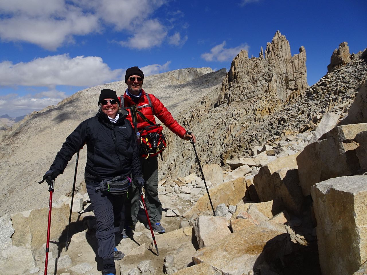
I got underway about an hour after she did. I tried my best to pace myself and not burn all of my energy trying to catch up with her. I was starting to worry I had allowed her too much time and she would have to wait for me at our agreed rendezvous point at the junction where the summit trail intersects with the trail going over and down the east side. If she stopped exercising, she would stop producing heat and would get cold fast. I finally spotted her above me at the second to last switchback. We got to the junction together.


It was a great relief to make it to the junction
Somehow we thought the hard work was done; it wasn't!
At the trail junction, we removed our heavy packs and pared down to a light day pack, which I carried. Even though we were at 13,500 feet, losing the weight of the big packs made us positively buoyant. We took big steps and zipped up the start of the trail.
It didn't last very long. Soon we came upon Mt. Muir. The trail there turned into a narrow jumble of boulders and the jagged remains of when the trail was dynamited out of the granite cliff face. There was ice on many of them as well as some snow and we had to be careful in order to keep from slipping. At one point, I was standing in front of Maryanne taking a picture of the view. She took a step back toward the cliff wall trying to give me more room. When she did, she slipped and slid toward me. Realizing she was about to kick me off of the cliff, she crumpled into a ball during her fall and landed at my feet without even touching me. I was completely oblivious to all of this until I heard her fall, so I was surprised to turn around to find her worried about me. She was the one that had just fallen. I had been fine the whole time.


The altitude and path made for slow progress - but at least spectacular views during the regular rests
The trail got so bad that Maryanne was starting to make noises about turning back. We were so close. We had already made it above 14,000 feet!
Since the junction, the trail had become a lot more crowded with day hikers who had ascended from Whitney Portal on the east side. We always had three or four other hikers in view each direction. One of the next people to pass us was John, the Ranger I met in Crabtree Meadows. We asked him about it and he said the condition of the trail would improve soon. We pressed on.
By the time we got to about 14,300 feet, the altitude was making us feel like we had the big packs on again. We came around a bend and could finally see the hut at the summit. That helped a lot.
There were about a dozen or so hikers scrambling around on the boulders at the summit taking pictures and generally congratulating each other. A few others were sat in the lee of the hut trying to escape the biting wind. It was 18F/-8C.


We made it!
We signed the book at the hut and then found a protected spot on a ledge out of the wind just on the other side of the boulder marking the summit. It had a USGS marker upon which the elevation was marked as 14,508 feet. We were at the top of the highest mountain in the 48 contiguous states.
We sat for a while enjoying the view and eating a lunch of trail mix and frozen granola bars. We knew we shouldn't be up there too long, so when we finished up, we climbed back up over the summit and headed down. Ah, that is so much easier than up.
We retraced our steps back to our packs, trying our best not to look too fresh for the poor people trudging their way to the top. Several people were milling around either dropping or picking up packs. Some were just resting. One spot, where I had almost left my pack, there was another where a very fearless marmot was brazenly chewing his way toward some sweet-smelling morsel inside. Several of us tried shooing him away, but you had to practically make contact to get him to back off. He knew he could wait us out. Eventually another hiker just dug into the guy's pack to retrieve the marmot's prize for him so he'd stop trying to chew his way to it.


And down again to our packs
I stuffed the day bag into my pack and we shouldered them once again. Oof! Not again! As one last kick in the teeth, we had to climb with them another 200 feet before we could start the long descent down the other side. That last 200 feet of elevation was a real killer. Not only was it way up there to begin with, that part of the trail was made of big, steep steps that were like taking stairs four at a time.
We were SO relieved when we finally passed through the pass at Trail Crest and started descending the switchbacks on the other side. The rocky trail was still pretty tough on the legs. It was made up of a jumble of small boulders with faces canted every which way EXCEPT horizontal. It was like traversing miles of earthquake rubble.
We lowered ourselves thousands of times onto rocks that were each just a broken ankle waiting to happen before we finally spotted a bit of flat dirt trail heading away from the slope below. Oh, I've never ached to walk on a normal surface so much in my life.


The descent seemed endless, and not so much easier either!
It wasn't long after we got there that it ended again and returned to ankle-breakers. We did that for a few more miles. It was awful. Each steep step was just big enough that we could lower ourselves almost all of the way on the uphill leg before we would have to drop and try to absorb the impact using our calf muscles. We saw several people going the other way and couldn't imagine the misery they must be suffering. Many were going too slow to be able to make it to the next campground by dark.


Camping at lone pine lake - a touch too windy to fully appreciate
By the time we made it to our campground at Lone Pine Lake, we both felt pretty much like we had sprained everything. There were a few guys there who seemed to be wrapping up a day of fishing. When they left, we had the whole little lake to ourselves. It was a really beautiful spot, but we could hardly move and the cold wind we had at the summit had continued down to us. We made a hasty dinner and retreated to the warmth of our bags and tent.
No comments:
Post a Comment