


Great day to view the glaciers! Thankfully there is a bus that will take us there
[Kyle]Saturday morning, we walked to the Ferry stop amidst a handful of backpackers that seemed to appear out of nowhere and caught the Glacier Bus. For about $25 each, we got a 5 minute ride, a 10 minute ride, and two 20 minute rides, no guide, no commentary, no nuttin’.
Well, it did take us to some beautiful places. The first stop was the Norsk Bremuseum, not one of them. From Footprint, we could see this at the head of the fjord and marveled at its astonishingly singular concrete ugliness in a land where everything else was pretty wooden structures with fresh paint. Once we got there, I think I kind of saw what the architects were going for. From the parking lot, and only from a very carefully selected spot in the parking lot, the building roughly approximates the lines of the mountains behind. I tried, but I still couldn’t bring myself to like it.


Glacier and Climate Museum
Once inside, we found that our enormous bus fare didn’t include the museum and forked over some more cash. The museum was really cool, though and did a good job of explaining practically everything you would want to know about glaciers, particularly Jostedalsbreen, the local glacier and the largest one in continental Europe at 487 km² with 22 outlet tongues. There were lots of cool, hands on displays where you could play with chunks of glacier ice that are brought down once a week and see how ice moves and bends around things.
From the museum, we reboarded the bus and headed up an increasingly narrow and beautiful valley to our first outlet tongue, Supphellebreen, where giant chunks of sky blue ice at the mountain top melted into roaring waterfalls plunging into a lazy river. Here, we could see the same cloudy blue water as further down in the Sognefjord. At the Bremuseum, we learned that this was caused by fine glacial silt that can take as much as two months (in still water) to settle out. That solves the mystery of the blue water. In the Caribbean, this blue is caused by water over a shallow white sand bottom. The Sognefjord is so deep that light cannot get to the bottom (light cannot penetrate below about 200 feet due to scattering, Sognefjord is 3000 feet deep in most places) The shallow sand bottom effect is caused by shallow entrained silt.


Supphellebreen Glacier
Next stop was Bøyabreen, a much bigger glacier set at the end of a u-shaped valley (I noticed the sign on the road said the tunnel out was 6370m long, Norway has the world’s longest road tunnel at 24.51km). Bøyabreen, in addition to the main glacier, has a secondary glacier further down the mountain. Secondary glaciers consist of permanent ice caused by refreezing of the original glacial melt water and have multi-year life cycles before melting again to form the river below. There was a café there that the bus conveniently left us with enough time for and some beautiful places to sit and watch the waterfalls. I knew their game and wasn’t having any of it. Maryanne and I tramped all over the place in the allotted time, camera in one hand and a packed sandwich in the other. We got to see many places on little used trails well away from edge of the parking lot, where few of the other passengers ventured. This place is just too beautiful.


Bøyabreen Glacier Visit
[Maryanne]We wern't misinformed about the bus, we just assumed too much. We thought it would take us to the top of the mountains to view the main glaciers, however it took us to some of the lower tongues, and let us view them up from the base - in fact glaciers that we could have walked to if we'd have understood their location. The bus drive probably didn't climb more than 150m either, it would have been a mostly flat walk. Given what we received, we were very disappointed with the cost. Kyle was keen to climb to the main glacier and we agreed there was plenty of time for the hike up the Toblerone - what was I letting myself in for? We were not properly prepared for a mountain hike - I still had my handbag for instance!!
[Kyle]We eventually reboarded the bus at the Bøyabreen glacier and elected, rather than return to Fjærland, we got off at the Norsk Bremuseum and walked back most of the way to Supphellebreen to the trailhead for the Flatbrehytta. Flatbehytta is an overnight hut used by hikers and cross country skiers (who set out across Jostadalsbreen), perched at a viewpoint high above the Fjærlandsfjord at an altitude of 1000 meters.


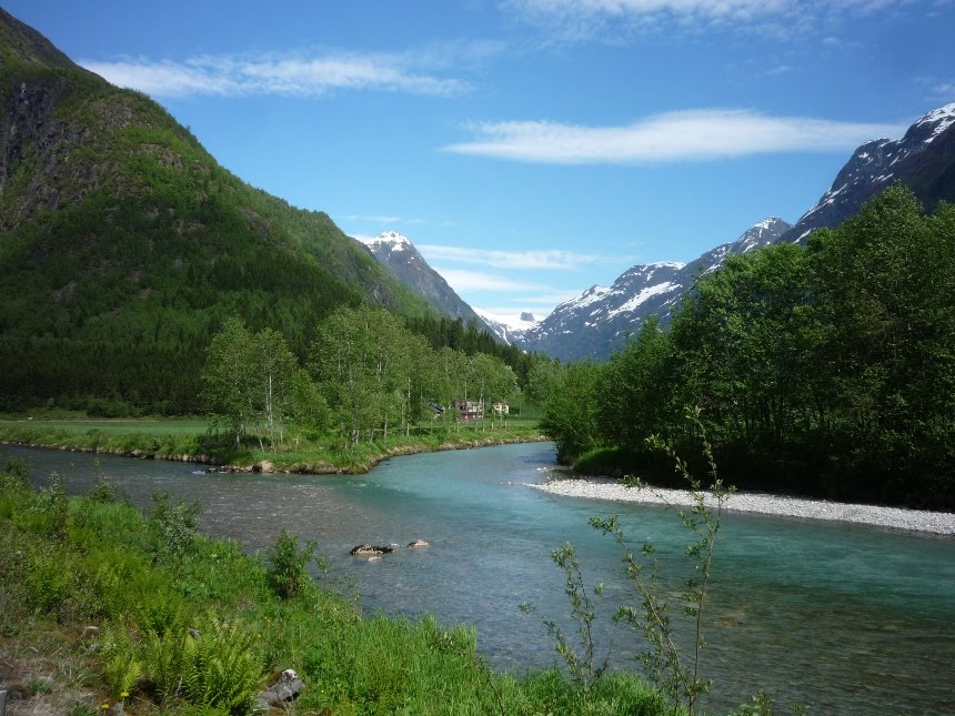
Views from a lovely stroll back to the start of the trail
I was a little tired and sore (with blisters from our hike to clear in) when we started the hike, but I had seen pictures of Flatbrehytta and really, really wanted to see it. Most of the trail up was done at a completely unrelenting 30° angle, the rest was steeper, often much steeper running alongside one of the roaring glacial rivers plunging down the mountain. Once the trail was high enough, the trail crossed the river over the ice of the secondary glacier as the water rushed underneath.


What a hike
On the other side, the trail got steeper. We spent over an hour climbing switchbacks with knee-high steps before we finally emerged at the tree line to stunning views of the valley below and our first real sight of our vertical progress. As we sailed up the Fjærlandsfjord the day before, Maryanne remarked that all of the mountains looked like Toblerones. The one immediately to our right was the mini-Toblerone, about ¾ the height of the rest. We were just under halfway up. Oof!
The trail climbed onto a ridge about 10 feet wide and steepened further as it zigzagged back and forth over the available width. Maybe half the time, we found ourselves using our hands to help pull us up to the next step. In spite of the steepness of the trail and all we had already done, we found ourselves buoyed by the amazing views that now surrounded us and the knowledge that every step taken made them better. We passed a group on their way down. The guide gave us some advice for the trail ahead and assured us we should be there in just over an hour. Auchh!, an hour!


The mountains around here are really steep, and high... what were we thinking!
We got to the spot where the guide said the trail got confusing because of all of the snow cover and followed her advice. That worked out pretty well until the trail just mysteriously stopped – no footprints in the snow or anything. Several places in the wet moss looked like they could have been squished out trails, but, then again, maybe not.


Almost there
By that point we could see the hut and a couple of people walking around at the top as well as the final, well worn part of the trail through the snow. We just couldn’t figure out how to get there. Our alternatives were a long backtrack to where the trail split, where we would have the opportunity to subsequently avoid the guide’s advice, or somehow scramble our way up the moss and bushes to the snow trail. We were both much too tired to think about turning back, so we forged ahead.
It was pretty scary. We had an unclimbable wall to our right and a drop off to our left, with about 100ft wide section between of moss, bushes and occasional snow on about a 40° slope. We climbed by grabbing handfuls of plant to supplement the meager traction of our feet. We couldn’t stop for fear of roots pulling out or traction giving way and there were almost no flat spots to rest and wait for each other. We each climbed in our own personal Hell, knowing that any slip, no matter how small, would be unrecoverable.
We finally made to a narrow shelf and the beginning of the snow track, panting and exhausted, but happy to be through that mess. The afternoon sun had softened the snow and made it slippery. About every fifth step, we would break through, sometimes only a few inches, sometimes much further, leaving the other leg folded under us as we comically struggled to get back on the surface. After much struggle that we didn’t have the energy for, we finally stepped onto the hard ground surrounding the hut at Flatbrehytta and flopped with a thud onto the seats of a stone picnic table.


The Top, and the remotest loo I know
We explored the hut and found it very well provisioned. There were bunks, a table and chairs, a wood stove with a large selection of cookware, even a stack of firewood. We were also overjoyed to find a small store of sodas and biscuits for sale that had been brought up by helicopter. We gladly dropped our money in the honesty box. A Fanta has never tasted so good.


The top... It was worth it, but of course then you just have to climb back down again!
Then there was the view. It was ok. No, just kidding, it was unbelievable. We could see all the way down to the Fjord and, with the binoculars I had lugged all the way up there, I could just make out the speck of Footprint. We were surrounded by ice, snow and rock with green valley far below. We found ourselves towering high above the mini-Toblerone (which has a real Norwegian name, but it’s pretty much unpronounceable, like Eyjafjallajokull). We were accompanied at the hut by a couple of Norwegians who were planning on staying the night. They suggested we follow the short trail across the snow to the edge of Supphellebreen that we had seen from below that morning. The snow was really soft. Maryanne gave up first, about ten steps later, I fell through (again) and this time, could not feel bottom. There was no telling what was under the snow or how far it was. We decided we were content with making it to the hut.


Down still seemed like a long way away, but we still had time to enjoy the waterfalls on our alternate route down!
There was no way we were going back down the way we came. With advice from the Norwegians, we headed down a well-worn trail that was different than the one we came up. After a while, it too became lost in the boggy moss. We were still above the trees and could see where we were trying to go so we kept edging in the direction of the trail, sure we would pick it up again soon. Or path started getting blocked by cliffs and then, lower down, by trees. As we descended down further and further into the thickening growth our confidence that we were going to safely rejoin the trail decreased with each dead end. Eventually, we could see trees for only the next 30 feet or so and then nothing until the valley floor. We were nearing the edge of a big drop. We were cornered. Exhausted and scared, we had no alternative but to claw our way back up the hill, all the way to the hut if necessary. We were both completely knackered but did not want to spend the night on the mountain. The only thing going for us was that it was not going to get dark, so we could spend all night getting out if we had to.
After a long while, I climbed a small ridge to get our bearings and fund myself standing on the path down, right above the confusing part where it splits four ways in the snow and we were saved. That guide had given us bad advice (or we'd misunderstood). We had originally needed the second trail from the left, not the far one.
We managed to get back through the snow without breaking through and then descended the same steep trail we had used coming up. It took us two hours to get to the road. By then, my quads were aching from lowering myself down the steep hill. I didn’t even want to imagine what my poor feet looked like. I had blisters when we started up the trail. I have never been so happy to see a level dirt road in my life.
But, of course, we weren’t done. We still had several miles along the road at the base of the Toblerones before Footprint. We finally made it in the bright twilight just before midnight, doing that strange walk where you limp on both feet at the same time. Too tired for a real dinner, we ate a quick bowl of cereal each and went to bed. It was sooo good to lie down!
2 comments:
I'm kind of speechless, actually. I want to write a comment, but don't know what to say. I was telling myself as I read along that if the blog was written, you must have made it back safely in order to write it. So, okay, those are the basics. Beyond that--you're both nuts!
I can see what pulled you into this adventure and can only imagine what kept you moving toward Footprint on the way down. I heard about your blisters, Kyle. What damage did Maryanne do?
Oh, and the scenery is pretty much okay. Wow. Give it a rest, you two!
good grief, is there nothing you two won't do to burn calories? very impressive that you made it to the top and back down again - and the views are nothing short of amazing - but have a care, would you? :)
Post a Comment